
Visual satellite orbit position management method based on data mapping and b/s architecture

A data mapping and management method technology, applied in the field of aircraft control, can solve the problems of inability to realize detailed parameter query of a single satellite network, frequency analysis of a single satellite network, inconvenient use by satellite operators, etc., to achieve convenient system upgrades and maintenance , low cost, good compatibility

Active Publication Date: 2016-12-21
NANJING UNIV
View PDF2 Cites 0 Cited by
  • Summary
  • Abstract
  • Description
  • Claims
  • Application Information

AI Technical Summary

Problems solved by technology

The problem with this technology is that it cannot query the detailed parameters of a single satellite network, and cannot analyze the frequency of a single satellite network. It only supports the analysis and calculation of interference between the interfering network and the interfered network in the worst case defined, which is inconvenient. used by satellite operators
[0005] The above two methods are based on the C / S (Client / Server) mode, and the deployment and use are not flexible enough. Satellite operators need to install corresponding terminals, and the database system still uses the SRS database in MS-Access format, which is not conducive to transplantation and integration

Method used


Image

  • Visual satellite orbit position management method based on data mapping and b/s architecture
  • Visual satellite orbit position management method based on data mapping and b/s architecture
  • Visual satellite orbit position management method based on data mapping and b/s architecture

Examples


specific Embodiment approach

[0035] The specific implementation steps are as follows:

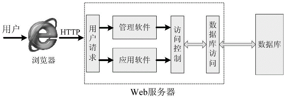
[0036] Step 1: Combine figure 1 , install Web server software in the host, such as MS-IIS, Apache, etc., create and run the Web site, connect the 100 / 1000Mb / s Ethernet card of the host to the LAN switch that accesses the network backbone, so that it can be accessed other devices on the network.

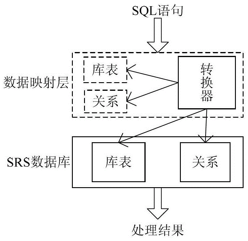
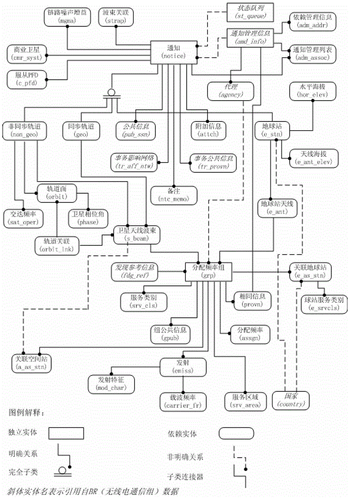
[0037] Step Two: Combine image 3 , in order to develop the SRS database, it is necessary to master all the table information in the SRS database and the relationship between the tables. However, the table names and field names in the SRS database are abbreviated, and the data types and forms are diverse, and the relationship between tables is very complicated, such as image 3 As shown, the ITU does not provide a description of the relationship between the tables, which brings great difficulties to the design of a visual satellite orbit interference coordination technology. In order to solve this problem, a data mapping l...


PUM


Abstract

The invention relates to a visual satellite orbital management method based on data mapping and a B / S structure. The visual satellite orbital management method includes the following steps that a data mapping layer is built; intelligent searching and graphical display of an SRS database are carried out based on the data mapping layer, the B / S structure and a rich client platform technology. The visual satellite orbital management method is easy to employ, free of installation, low in cost, strong in universality and good in capacity and maintenance is easy.

Description

technical field [0001] The invention belongs to the technical field of aerospace vehicle control, in particular to a visual satellite orbit position management method based on data mapping and B / S architecture. Background technique [0002] Satellite orbit interference coordination is a long-term, continuous and important work. ITU's "Radio Regulations" and related recommendations clarify the coordination principles and implementation procedures between satellite networks, give suggestions on the trigger coordination threshold for two satellite networks, and provide interference calculation methods, and provide MS-Access format The Space Radio Station (SRS) database, but there is no specific way to directly use it for interference coordination calculations, which causes inconvenience to satellite orbit interference coordination. Usually each satellite operator conducts according to their own understanding according to the relevant recommendations of the ITU. In bilateral co...

Claims


Application Information

Patent Timeline
Patent Type & Authority Patents(China)
IPC IPC(8): G06F17/30H04L29/08
CPCG06F16/248G06F16/252H04L67/02
Inventor 金凤林葛新许博何元智倪桂强
Owner NANJING UNIV
Learn More