Geographic and geomorphic characteristic construction method based on laser radar and image data fusion

A technology of lidar and image data, which is applied in the re-radiation of electromagnetic waves, the use of re-radiation, measurement devices, etc., can solve the problems of complex algorithms, huge calculation amount, and the inability to guarantee the accuracy of unmanned mobile platforms on the ground. the effect of reducing complexity

Active Publication Date: 2014-03-19
BEIJING INSTITUTE OF TECHNOLOGYGY
View PDF3 Cites 87 Cited by
  • Summary
  • Abstract
  • Description
  • Claims
  • Application Information

AI Technical Summary

Problems solved by technology

However, due to the lack of features for matching and fusion, the advantages of geometric information features of 3D lidar and multiple features of images cannot be used, and the accuracy of matching cannot be guaranteed.
[0008] To sum up, when constructing maps based on the existing methods, it is impossible to guarantee the accuracy of the ground unmanned mobile platform's understanding of the environment, and at the same time, complex algorithms and huge calculations cannot meet the requirements of modernization

Method used


Image

  • Geographic and geomorphic characteristic construction method based on laser radar and image data fusion
  • Geographic and geomorphic characteristic construction method based on laser radar and image data fusion
  • Geographic and geomorphic characteristic construction method based on laser radar and image data fusion

Examples


Embodiment Construction

[0051] The present invention will be described in detail below with reference to the accompanying drawings and examples.

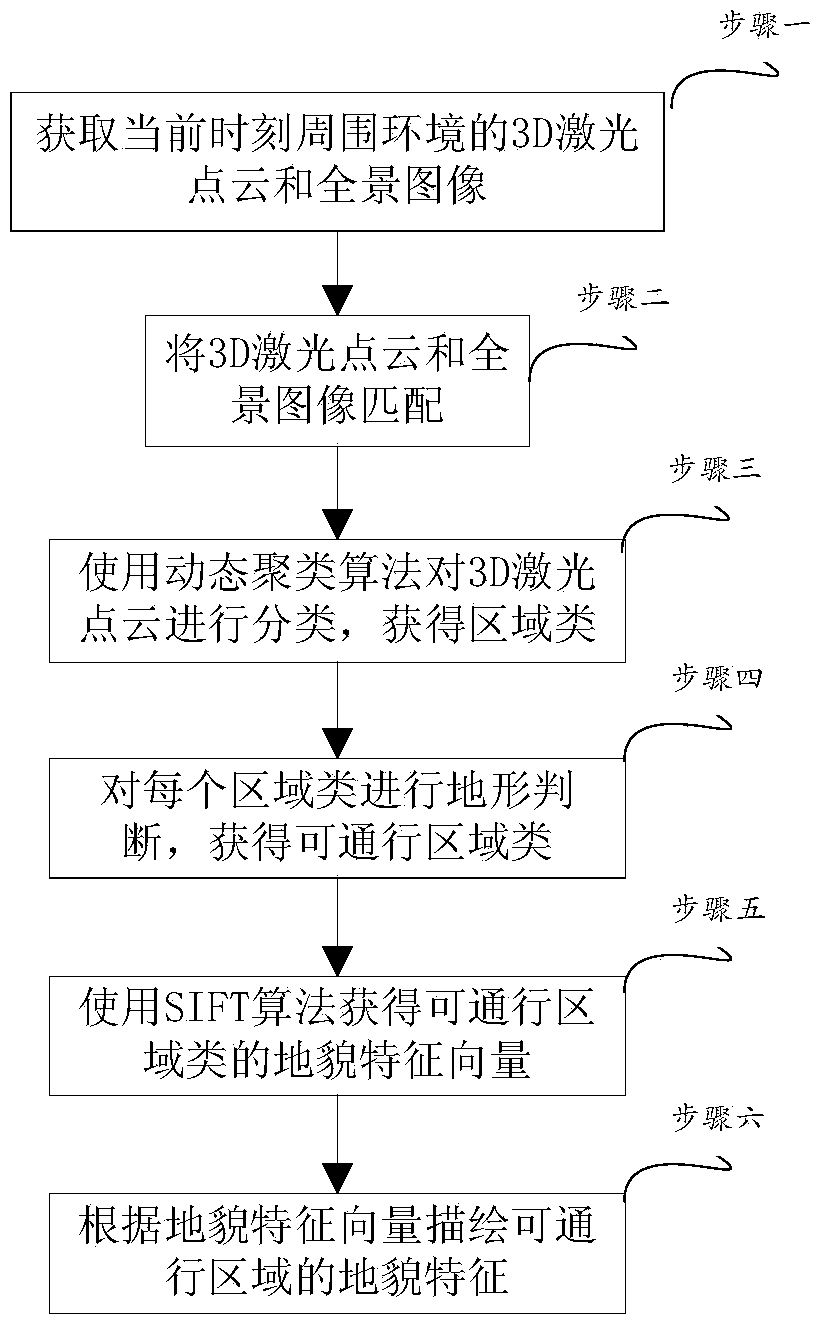
[0052] The invention provides a method for constructing a geographical environment map of a ground unmanned mobile platform. The method is as follows: figure 1 Shown:

[0053] Step 1. Obtain the 3D laser point cloud and panoramic image of the surrounding environment of the ground unmanned mobile platform at the current moment. The vehicle-mounted 3D laser radar can be used to obtain the 3D laser point cloud, and the panoramic camera can be used to obtain the panoramic image.

[0054] The above-mentioned 3D laser point cloud is a feature point set of the surrounding environment of the platform, including the three-dimensional coordinate values ​​and reflectivity of each feature point.

[0055] The panoramic camera in this embodiment includes cameras in 5 directions, collects 5 images, and matches and merges the 5 images to obtain a 360 panoramic image.

...


PUM


Abstract

The invention discloses a geographic and geomorphic characteristic construction method based on laser radar and image data fusion and belongs to the automatic control field. The method specifically comprises 1) obtaining 3D laser point clouds and panoramic pictures of the surrounding environment of a ground unmanned mobile platform at present; 2) matching the 3D laser point clouds and the panoramic pictures and obtaining matched images; 3) dividing the 3D laser point clouds based on different distribution characteristics corresponding to each laser point and carrying out clustering based on a dynamic clustering algorithm of each distribution characteristic to obtain a plurality of region classes; 4) finding passable region classes in the plurality of region classes based on travel ability of the ground unmanned mobile platform; 5)obtaining landform identification vectors of the passable region classes by utilizing a denseness SIFT algorithm; and 6) carrying out landform classification on the passable region classes based on the landform identification vectors and by utilizing a classifier. The method is suitable for passable geographic and geomorphic characteristic construction of the ground unmanned mobile platform.

Description

technical field [0001] The invention belongs to the field of automatic control, and in particular relates to a method for establishing a geographical environment map by using 3D laser radar and camera image information carried on a ground unmanned mobile platform. Background technique [0002] The unmanned ground mobile platform UGP is a comprehensive system integrating multiple functions such as environmental perception, dynamic decision-making and planning, behavior control and execution. It has broad application prospects in the fields of future military, intelligent transportation, and disaster relief. The mobility and intelligence of UGP depend on its autonomous navigation capability, and the accurate and fast autonomous navigation function is based on the map information of the precise geographical environment. [0003] Studying advanced geographic environment map construction methods will help to enhance the intelligence of ground unmanned mobile platforms and broaden...

Claims


Application Information

Patent Timeline
Patent Type & Authority Applications(China)
IPC IPC(8): G01S17/89
CPCG01S17/87G01S17/89
Inventor 王美玲彭佳
Owner BEIJING INSTITUTE OF TECHNOLOGYGY
Why Eureka
Try Eureka