Integrated navigation system and method based on SINS (Strapdown Inertial Navigation System) and star sensor

An integrated navigation system and strapdown inertial navigation technology, which is applied in the field of satellite attitude measurement, can solve the problems such as the inability of the star sensor to work, maintaining high precision, and limiting the application scope of the integrated navigation system.

Active Publication Date: 2014-03-26
HARBIN INST OF TECH
View PDF5 Cites 31 Cited by
  • Summary
  • Abstract
  • Description
  • Claims
  • Application Information

AI Technical Summary

Problems solved by technology

[0017] Further, the research shows that, under the condition that the lowest magnitude detectable by the star sensor is 6.5 and the field of view is 12°×12°, the probability that there are more than 3 stars in the field of view of the star sensor in the entire celestial sphere is 90.4% %, that is to say, 9.6% of the star sensor cannot work, especially near the north celestial pole (70°~90°, 220°~240°), because the stars a

Method used


Image

  • Integrated navigation system and method based on SINS (Strapdown Inertial Navigation System) and star sensor
  • Integrated navigation system and method based on SINS (Strapdown Inertial Navigation System) and star sensor
  • Integrated navigation system and method based on SINS (Strapdown Inertial Navigation System) and star sensor

Examples


Embodiment Construction

[0102] The technical solutions of the various embodiments of the present invention will be clearly and completely described below in conjunction with the accompanying drawings. Apparently, the described embodiments are only some of the embodiments of the present invention, not all of them. Based on the embodiments of the present invention, all other embodiments obtained by persons of ordinary skill in the art without making creative efforts belong to the protection scope of the present invention.

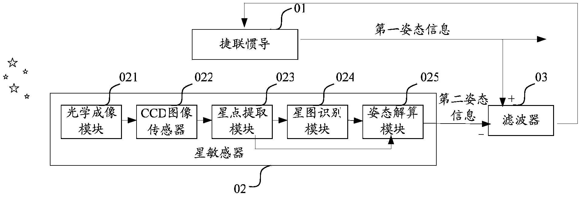
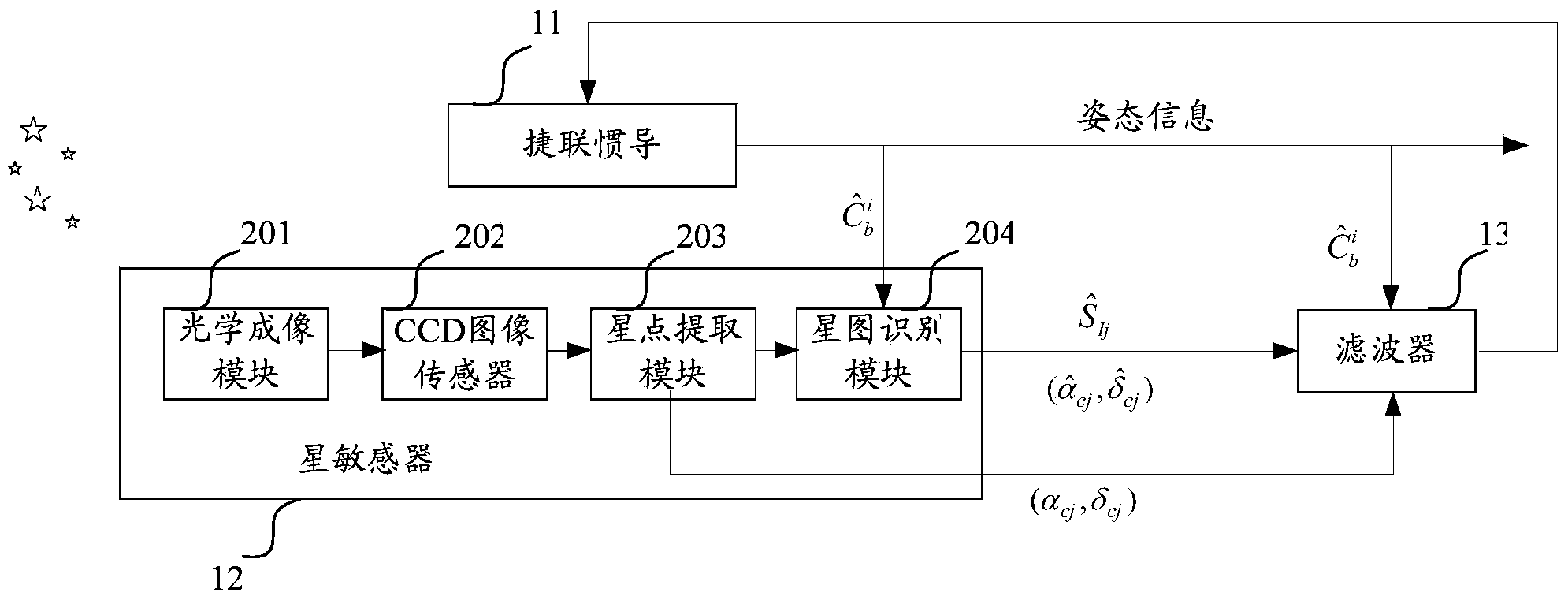
[0103] The existing loosely integrated navigation system based on inertial navigation and star sensor performs data fusion of the second position information and second attitude information provided by the star sensor with the first position information and first attitude information provided by strapdown inertial navigation , get the optimal estimate of the state error term of the SINS, correct the mathematical platform of the SINS, and then correct the position information and atti...


PUM


Abstract

The invention discloses an integrated navigation system and method based on an SINS and a star sensor. The integrated navigation system comprises the SINS, the star sensor and a filter, wherein the SINS is used for detecting the attitude information of a carrier, and amending the attitude information according to the optimum estimate of a state error term; the star sensor is used for acquiring the longitude and latitude, in a star sensor coordinate system, of an imaged fixed star, the direction unit vector, in a geocentric inertial coordinate system, of a reference fixed star matched with the imaged fixed star, and the longitude and latitude, in the star sensor coordinate system, of the reference fixed star; when the number of fixed stars observed by the star sensor is one or two, the filter is used for acquiring the optimum estimate of the state error term of the SINS according to an observation equation, wherein the observation equation is established by taking a longitude and latitude difference as a state quantity and by taking the pre-established error equation of the SINS as a state equation, and the longitude and latitude difference is composed of the longitude difference and latitude difference, in the star sensor coordinate system, between the reference fixed star and the imaged fixed star. According to the invention, the application range of the integrated navigation system can be widened.

Description

technical field [0001] The invention relates to the technical field of satellite attitude measurement, in particular to a combined navigation system and method based on strapdown inertial navigation and star sensors. Background technique [0002] With the in-depth development of space technology, the demand for long-life, high-precision satellite attitude measurement system is increasingly strong. At present, in the field of aerospace, the navigation system with high precision, high reliability and strong autonomy is mainly used as the satellite attitude measurement system to provide the motion parameter information of the aircraft carrier. [0003] Currently commonly used navigation methods include inertial navigation, satellite navigation, and astronomical navigation. Among them, inertial navigation is fully autonomous, can continuously provide all motion parameter information, and has high accuracy in a short period of time. However, it is limited by the inertial devices ...

Claims


Application Information

Patent Timeline
IPC IPC(8): G01C21/02G01C21/16
CPCG01C21/165
Inventor 伊国兴李清华奚伯齐谢阳光祁子洋
Owner HARBIN INST OF TECH
Why Eureka
Try Eureka