An underground pipe network wireless monitoring positioning system

A technology for positioning systems and underground pipe networks, applied in transmission systems, wireless communications, network topology, etc.

Inactive Publication Date: 2014-03-26
CHINA ACADEMY OF MACHINERY SCIENCE & TECHNOLOGY +1
View PDF3 Cites 5 Cited by
  • Summary
  • Abstract
  • Description
  • Claims
  • Application Information

AI Technical Summary

Problems solved by technology

[0012] To sum up, there is currently no systematic method in the field of underground pipeline network monitoring that can realize the location of monitoring nodes and the source of sudden disaster accidents, and at the same time take into account the communication capabilities, data processing capabilities, storage capabilities, reliability, cost, and cost of a large number of monitoring nodes. Power consumption, speed, efficiency and other issues

Method used


Image

  • An underground pipe network wireless monitoring positioning system

Examples


Embodiment 2

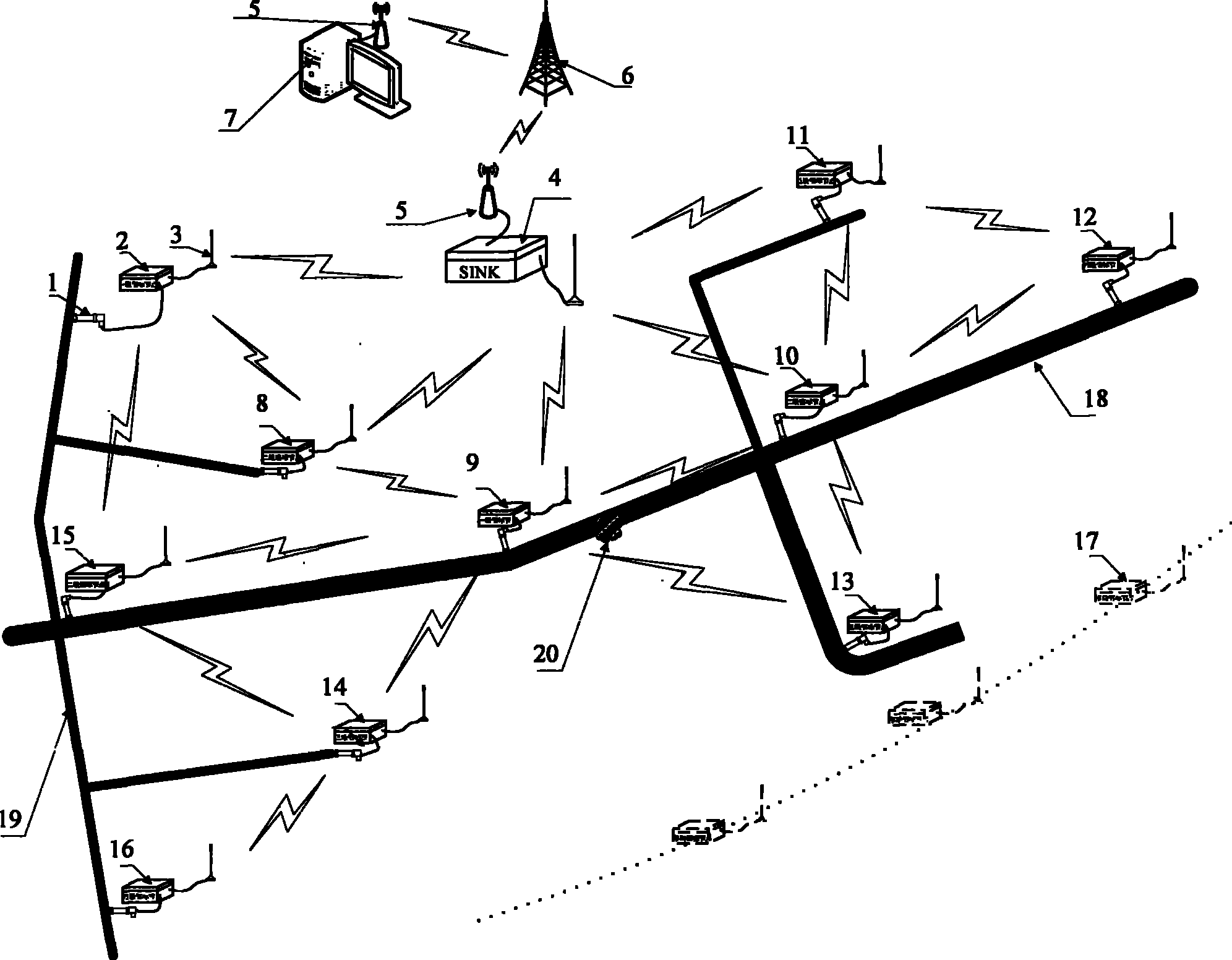
[0045] The monitoring node (unknown node) 8 of the present invention obtains the position information of the monitoring node 8 by receiving the positioning information of the beacon nodes 2, 9 and the sink node 4, and the monitoring node 8 is converted into two Level beacon nodes, monitoring node 8 feeds back location information, and beacon nodes 2 and 9 revise relational functions.

Embodiment 3

[0047]The monitoring node (unknown node) 15 of the present invention obtains the position information of the monitoring node 15 by receiving the positioning information of the beacon nodes 2 and 9 by using the incremental trilateral calculation method, and receives the positioning information of the secondary beacon node 8. The information corrects the position information of the monitoring node 15, the monitoring node 15 is transformed into a secondary beacon node, the monitoring node 15 feeds back the position information, and the beacon nodes 2 and 9 modify the relationship function.

[0048] Monitoring node positioning embodiment four:

[0049] The monitoring node (unknown node) 14 of the present invention adopts the incremental trilateral calculation method by receiving the positioning information of the first-level beacon node 9 and the second-level beacon node 15. The position information of the monitoring node 14 is obtained, the monitoring node 14 is transformed into ...

Embodiment 8

[0057] The sudden disaster accident 20 described in the present invention, the time that monitoring node 9,10 detects the sudden change signal of pipe network operation state is different, according to the time difference algorithm, obtain the distance of sudden disaster accident position 20 and monitoring node 9,10, Determine the location of the emergency disaster accident 20, calculate the distance between the emergency accident 20 and the monitoring nodes 11, 12, 13, and 15 through the time when the mutation signal arrives at the monitoring nodes 11, 12, 13, and 15, and correct the location of the emergency accident 20.


PUM


Abstract

The invention discloses a wireless monitoring positioning system applicable to the field of underground pipe network application. The wireless monitoring positioning system is composes of unknown nodes, beacon nodes, Sink nodes, a host computer, etc. The invention discloses a monitoring node positioning method targeting at a wireless self-organizing network, i.e., a progressive incremental type distance measuring positioning algorithm based on an on-line optimization training relation function, and a process of continuous correction of positioning results through the adoption of a plurality of methods. The invention also discloses an sudden-onset disaster accident source positioning method targeting at underground pipe network application, and the sudden-onset disaster accident source positioning method the comprises a time difference method, a state curve method, a multiparameter combination method, etc., and a plurality of methods are adopted to carry out positioning correction, so that positioning with relatively high precision can be realized. The invention also discloses an energy saving optimization method for a realization process of the above positioning method. Through the adoption of the positioning method of the present invention, functions such as underground pipe network automation intelligentized monitoring early warning and sudden-onset disaster highly efficient reliable positioning can be realized, and the positioning method is also advantaged by being accurate in data, being timely and highly efficiently, being low in energy consumption and low in cost, etc.

Description

technical field [0001] The present invention belongs to the technical field of wireless remote monitoring of underground pipe networks. Specifically, firstly, the present invention relates to wireless remote monitoring and positioning system equipment for underground pipe networks; secondly, the present invention relates to a self-organizing network positioning method for wireless monitoring systems; thirdly, , the present invention relates to the practical application of the wireless monitoring system in the field of underground pipe network emergency location, specifically event-driven technology to realize the rapid location of the source of the emergency; fourth, the present invention relates to an energy-saving optimization method for the implementation process of the location algorithm. Background technique [0002] GPS (Global Positioning System) is the most famous positioning service currently in use. However, because wireless sensor nodes are limited by cost, energy...

Claims


Application Information

Patent Timeline
Patent Type & Authority Applications(China)
IPC IPC(8): H04W84/18H04L29/08
CPCY02B60/50Y02D30/70
Inventor 张利强杨前进韩新民田宝庆张彦伯
Owner CHINA ACADEMY OF MACHINERY SCIENCE & TECHNOLOGY
Why Eureka
Try Eureka