
Satellite-borne multi-channel synthetic aperture radar imaging device

A technology of synthetic aperture radar and imaging device, which can be used in measurement devices, reflection/re-radiation of radio waves, utilization of re-radiation, etc., and can solve problems such as system performance degradation and signal energy reduction.

Active Publication Date: 2014-04-23
AEROSPACE INFORMATION RES INST CAS
View PDF3 Cites 32 Cited by
  • Summary
  • Abstract
  • Description
  • Claims
  • Application Information

AI Technical Summary

Problems solved by technology

[0006] In view of this, in order to solve the technical problem that the transmitting beam must be wide enough in the elevation direction in order to achieve a wide surveying band in the prior art, but this will reduce the signal energy and reduce the system performance, the main purpose of the present invention is to provide a A spaceborne multi-channel synthetic aperture radar imaging device that realizes high resolution in azimuth and wide range mapping at the same time

Method used


Image

  • Satellite-borne multi-channel synthetic aperture radar imaging device
  • Satellite-borne multi-channel synthetic aperture radar imaging device
  • Satellite-borne multi-channel synthetic aperture radar imaging device

Examples


Embodiment 1

[0060] Table 1

[0061] Figure 7 It is the wave position selection diagram of the SAR system in this embodiment, and the downward viewing angle is from 15 degrees to 52 degrees. The swath width is 90 kilometers, and the azimuth and range resolutions are up to 1 meter.

[0062] Figure 8 It is the equivalent backscatter coefficient (NESZ) curve diagram, wherein the solid line is the result of the design system, and the dotted line is the NESZ curve of the traditional single-channel SAR system. As can be seen from the figure, the spaceborne SAR system based on the present embodiment with higher sensitivity. Therefore, the performance of the system has been greatly improved.

[0063] Figure 9 is the range ambiguity (RASR) curve diagram, in which the solid line is the range ambiguity result of the designed system, and the dotted line is the RASR curve of the traditional single-channel SAR system. It can be seen from the figure that the range ambiguity value of the sy...


PUM


Abstract

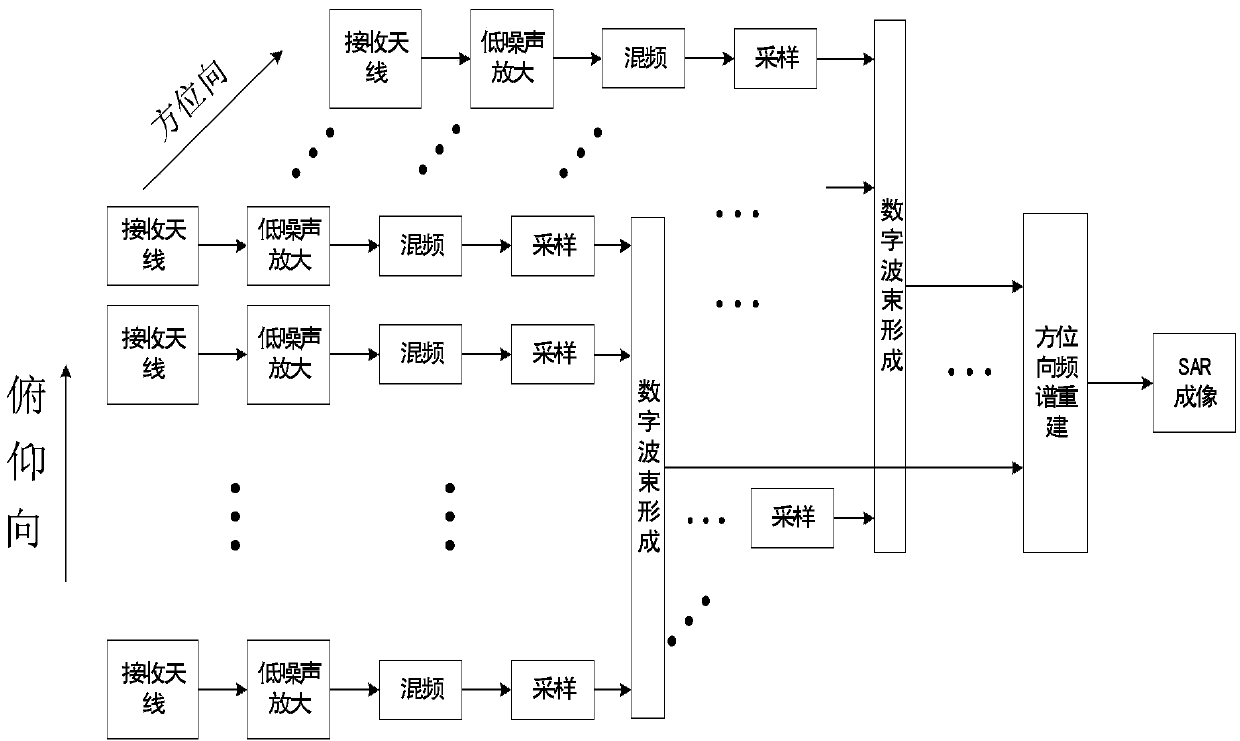
The invention relates to a satellite-borne multi-channel synthetic aperture radar imaging device, which is characterized in that multiple channels of pitching direction receiving antenna assemblies are arranged in the pitching direction of the radar at equal distance, echoes received by the multiple channels of pitching direction receiving antenna assemblies are formed into a channel of echo signal after passing through pitching direction digital beam forming units, multiple channels of pitching direction receiving antennas corresponding to the channel of echo signal are used as a row of receiving antennas, multiple rows of azimuth receiving antenna assemblies are arranged in the azimuth of the radar, multiple echo signals are formed after the multiple rows of azimuth receiving antenna assemblies pass through respective digital beam forming units, and enter azimuth frequency spectrum reestablishing units to be subjected to azimuth frequency spectrum reestablishing, the azimuth frequency spectrum reestablishing units are respectively connected with the multiple channels of pitching direction digital beam forming units for carrying out azimuth frequency spectrum reestablishing on the multiple channels of echo signals to generate and output a synthetic aperture radar echo signal, and an imaging device is connected with the azimuth frequency spectrum reestablishing units, and is used for receiving and generating the synthetic aperture radar echo signal into a synthetic aperture radar image.

Description

technical field [0001] The invention relates to the design and realization of a high-performance space-borne multi-channel SAR system, especially the design of multi-channel technology in pitch direction DBF and azimuth direction. Background technique [0002] The most important problem facing the design of a high-performance spaceborne SAR system is: how to achieve high resolution in azimuth and at the same time realize a wide swath in range. [0003] At present, for traditional SAR systems, in order to achieve high resolution in azimuth, a large Doppler bandwidth is required in azimuth. pulse repetition frequency) must be high enough. A high pulse repetition frequency will shorten the echo receiving window of the radar system, thereby reducing the mapping bandwidth, so high resolution in azimuth and wide mapping band in range are a pair of contradictions. [0004] To sum up, how to achieve high resolution in azimuth and wide swath in range is an urgent problem to be solv...

Claims


Application Information

Patent Timeline
Patent Type & Authority Applications(China)
IPC IPC(8): G01S13/90
CPCG01S13/9035G01S7/03G01S7/42G01S13/90G01S13/904
Inventor 王伟邓云凯王宇张志敏禹卫东赵凤军徐伟郭磊侯丽丽
Owner AEROSPACE INFORMATION RES INST CAS
Learn More