Thematic map building method and mobile terminal applying same

A thematic map and mobile terminal technology, applied in the field of building thematic maps, can solve the problems of not supporting custom map data sources, inability to overlay layers, and inability to build thematic maps that meet specific needs, etc.

Inactive Publication Date: 2014-04-23
CHINARS GEOINFORMATICS GUANG DONG
View PDF3 Cites 18 Cited by
  • Summary
  • Abstract
  • Description
  • Claims
  • Application Information

AI Technical Summary

Problems solved by technology

[0005] At present, the map SDK (SDK (Software Development Kit, software development kit)) of most mobile platforms only supports one of the services, and does not support custom map data sources, and cannot perform layer overlay, so it cannot be built Produce thematic maps that meet specific needs

Method used


Image

  • Thematic map building method and mobile terminal applying same
  • Thematic map building method and mobile terminal applying same

Examples


Embodiment Construction

[0021] In this embodiment, the present invention is applied to a smart phone using an Android system. In order to facilitate the understanding of those skilled in the art, the present invention will be further described below in conjunction with the accompanying drawings.

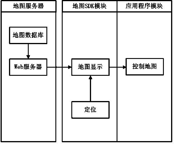
[0022] as attached figure 1 As shown, it is a schematic diagram of structural modules of an OGC map data system, and the OGC map data system includes a map server, a map SDK module, and an application program module.

[0023] The map server can be an OGC map server created by a user-defined data source, or a map server (such as ArcGis Server and GeoServer) that provides OGC map tile data on the Internet. Whether it is an OGC map server created by a custom data source or a map server that provides OGC map tile data on the Internet, you need to know its service type (WMS, TMS or WTMS) and access address, tile range and origin, zoom range, display In order to access the map server, the level and other relevan...


PUM


Abstract

The invention discloses a thematic map building method. The thematic map building method includes: judging the type of a map service according to a map data source selected by a user; adopting a corresponding algorithm to operate a map location, requested by the user, relatively according to the type of the map service so as to obtain corresponding tile coordinates; generating a URL (uniform resource locator) address of a special map service by utilizing the tile coordinates, and requesting to a map server successively to obtain corresponding map tiles; performing map layer overlapping on the obtained map tiles, displaying the map tiles successively at the same position on a screen, and thereby obtaining a required thematic map. The thematic map building method is applied to mobile platforms like smartphones, so that users can access to different tile map services conveniently while checking maps, can operate the multiple map layers of the map in operation, like switching and overlaying, and can operate the map, like translating and zooming.

Description

technical field [0001] The invention relates to a method for constructing a thematic map and a mobile terminal using the method to construct the thematic map. Background technique [0002] With the rapid development and wide application of mobile Internet and GIS, enterprises and individual users have a growing demand for thematic maps. [0003] Geographic Information System (Geographic Information System or Geo-Information system, GIS) is sometimes called "geographic information system". It is a specific and very important spatial information system. It is a technical system that collects, stores, manages, calculates, analyzes, displays and describes the relevant geographical distribution data in the space of the entire or part of the earth's surface (including the atmosphere) with the support of computer hardware and software systems. [0004] Thematic maps are often relatively small in scope, but thematic maps are targeted, and their data is more professional and specif...

Claims


Application Information

Patent Timeline
Patent Type & Authority Applications(China)
IPC IPC(8): G06F17/30
CPCG06F16/29
Inventor 刘丹枫王永强范海生任伏虎王晋年杨龙萧畅成
Owner CHINARS GEOINFORMATICS GUANG DONG
Why Eureka
Try Eureka