DEM (Digital Elevation Model)-assisted satellite image block adjustment method

A technology of digital elevation model and area network adjustment, which is used in electrical digital data processing, photo interpretation, special data processing applications, etc. Reasonable results

Active Publication Date: 2014-05-28
WUHAN UNIV
View PDF3 Cites 43 Cited by
  • Summary
  • Abstract
  • Description
  • Claims
  • Application Information

AI Technical Summary

Problems solved by technology

Overcome the problem of unreliable results or uneven accuracy of results when using

Method used


Image

  • DEM (Digital Elevation Model)-assisted satellite image block adjustment method
  • DEM (Digital Elevation Model)-assisted satellite image block adjustment method
  • DEM (Digital Elevation Model)-assisted satellite image block adjustment method

Examples


Embodiment Construction

[0040] Below in conjunction with accompanying drawing, the present invention is described in further detail.

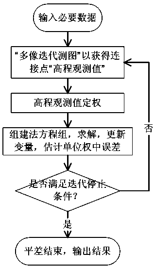
[0041] The technical solution provided by the present invention is a digital elevation model-assisted satellite image area network adjustment method, such as figure 1 shown, including the following steps,

[0042] Step 1. Data preparation;

[0043] Prepare the connection point matching results of the image in the regional network, the object space coordinates of the control points, the image space coordinates of the control points, the DEM data of the corresponding area, and the parameters for converting the DEM from its own coordinate system to the longitude and latitude coordinate system under WGS-84;

[0044] Step 2, obtain the virtual elevation observation value;

[0045] Connect the connection points with the same name, and use the "multi-image iterative back projection method" combined with DEM data to obtain the object plane coordinates of the connection poin...


PUM


Abstract

The invention provides a DEM (Digital Elevation Model)-assisted satellite image block adjustment method. The DEM-assisted satellite image block adjustment method is characterized in that existing DEM data are combined, elevation control is provided when block adjustment is carried out by using an RFM (Rational Function Model) by a satellite image, and thus the dependence of the satellite image on ground control points which are densely distributed when the block adjustment is carried out can be greatly reduced. According to the DEM-assisted satellite image block adjustment method disclosed by the invention, compared with a non-elevation-control traditional block adjustment, when the block adjustment is carried out on a weak-intersection high-resolution downward-looking (panchromatic and multi-spectral) satellite image, and the increasing of the result accuracy is particularly obvious; extremely-high edge matching accuracy and relatively-uniform absolute accuracy can be obtained by the satellite image in a larger regional network just by using a few object space plane elevation control points. The DEM-assisted satellite image block adjustment method disclosed by the invention is very suitable for a satellite image user by whom high-accuracy object space control points are difficult to obtain to a large extent.

Description

technical field [0001] The invention belongs to the field of surveying and mapping science and technology, and relates to a digital elevation model-assisted satellite image area network adjustment method, which is mainly used in the fields of automatic aerial triangulation of high-resolution satellite remote sensing images, high-precision orthophoto production, and the like. Background technique [0002] Block adjustment is a method for global optimization of image orientation parameters in photogrammetry. The most commonly used method at present is the bundle method block adjustment. For example: in the production of photogrammetry using a frame camera, the strict collinear equation model is used to carry out the block adjustment of the beam method. In this process, the image points will simulate the beam in photography through the collinear equation. During the process, when the light rays corresponding to the image points of the same name point reach the optimal intersec...

Claims


Application Information

Patent Timeline
IPC IPC(8): G06F19/00G01C11/34
Inventor 张永军万一黄心蕙凌霄
Owner WUHAN UNIV
Why Eureka
Try Eureka