Automatic extracting method of urban built-up area border

A technology of automatic extraction and built-up area, applied in image analysis, instrumentation, calculation, etc., can solve the problems of inability to process high-resolution full-color images and large amount of calculation.

Active Publication Date: 2014-05-28
WUHAN UNIV
View PDF3 Cites 24 Cited by
  • Summary
  • Abstract
  • Description
  • Claims
  • Application Information

AI Technical Summary

Problems solved by technology

[0004] Traditional urban built-up area boundary extraction methods are either only suitable for panchromatic images with a single center and less open space and water area, or only proved to be effective for low- and medium-resolution remote sensing images, or are too computationally intensive to handle images with multiple centers or High-resolution panchromatic images with large areas of open land and water have certain limitations

Method used


Image

  • Automatic extracting method of urban built-up area border
  • Automatic extracting method of urban built-up area border
  • Automatic extracting method of urban built-up area border

Examples


example

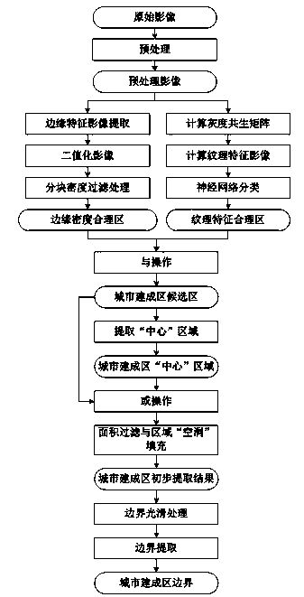
[0125] Taking the resource No. 3 panchromatic remote sensing image of Wuhan in 2007 as an example, the method of the present invention is used to study the boundary extraction of urban built-up areas. Wuhan is a typical city with multiple centers. The Yangtze River and numerous lakes that run through divide Wuhan into three towns: Wuchang, Hankou and Hanyang. The specific implementation process of the example is as follows:

[0126] 1) The image is stretched for the mean value of histogram.

[0127] 2) First, the Roberts operator is used to extract the edge feature image of the urban built-up area, and the Otsu automatic threshold segmentation method is used to binarize it, and the optimal threshold K is calculated as 11. Then divide the binarized image into a number of sub-region images of 128*128 size, calculate the density ρ of each sub-region image, set the density threshold T to 0.1, and perform block density according to equations (1) and (2) Filter to obtain a reasonable e...


PUM


Abstract

The invention relates to an automatic extracting method of an urban built-up area border, and in particular relates to a method applied to a high-resolution panchromatic remote-sensing image and used for automatically extracting the urban built-up area border, and belongs to the field of urban planning. The method comprises the following steps: firstly performing histogram mean value stretching treatment on the image, and extracting a reasonable edge density area of the urban built-up area based on an edge detection operator, and extracting a textural feature reasonable area based on a gray level co-occurrence matrix and neutral network algorithm, operating the reasonable area with the edge density and the reasonable area of the textural feature to obtain a candidate area of the urban built-up area, finely extracting by using a partitioning density filter method and a mathematical morphology method, and performing smooth treatment on the border by using the mathematical morphology method and extracting the urban built-up area border. The region with a plurality of centers and relatively large space water areas can be effectively treated to make up the insufficiency of an existing method, and the extracted urban built-up border has the high precision.

Description

Technical field [0001] The invention relates to a method for automatically extracting the boundaries of urban built-up areas, in particular, it is applied to high-resolution panchromatic remote sensing images to automatically extract the boundaries of urban built-up areas. The method makes full use of the edges of urban built-up areas in high-resolution panchromatic remote sensing images. The density feature and texture feature effectively realize the extraction of the boundary of the urban built-up area, which belongs to the field of urban planning. Background technique [0002] The scope of urban built-up areas reflects the scale of a city's development, and is a very important indicator in urban planning. The area of ​​urban built-up areas is also the basis for calculating a series of indicators such as population density, public facility level, urban output value per unit area, and urban expansion coefficient. Accurately extracting the boundaries of urban built-up areas is t...

Claims


Application Information

Patent Timeline
Patent Type & Authority Applications(China)
IPC IPC(8): G06T7/60
Inventor 刘耀林李海江焦利民刘艳芳谭荣辉邱丽娟
Owner WUHAN UNIV
Why Eureka
Try Eureka