Two-dimensional Nonlinear Frequency Modulation Method for SAR Imaging in Geosynchronous Orbit

A geosynchronous orbit, non-linear technology, applied in the use of re-radiation, radio wave measurement system, radio wave reflection/re-radiation, etc., can solve the problems of imaging scenes and imaging resolution constraints, ignoring azimuth and space variability, etc.

Active Publication Date: 2016-01-20
BEIJING INSTITUTE OF TECHNOLOGYGY
View PDF3 Cites 0 Cited by
  • Summary
  • Abstract
  • Description
  • Claims
  • Application Information

AI Technical Summary

Problems solved by technology

In the traditional GEOSAR imaging algorithm, the nonlinear frequency modulation (NCS) algorithm is a relatively accurate imaging algorithm, but because the azimuth and space variability of GEOSAR imaging parameters are ignored, the imaging scene and imaging resolution are restricted.

Method used


Image

  • Two-dimensional Nonlinear Frequency Modulation Method for SAR Imaging in Geosynchronous Orbit
  • Two-dimensional Nonlinear Frequency Modulation Method for SAR Imaging in Geosynchronous Orbit
  • Two-dimensional Nonlinear Frequency Modulation Method for SAR Imaging in Geosynchronous Orbit

Examples


Embodiment Construction

[0058] The present invention will be described in detail below with reference to the accompanying drawings and embodiments.

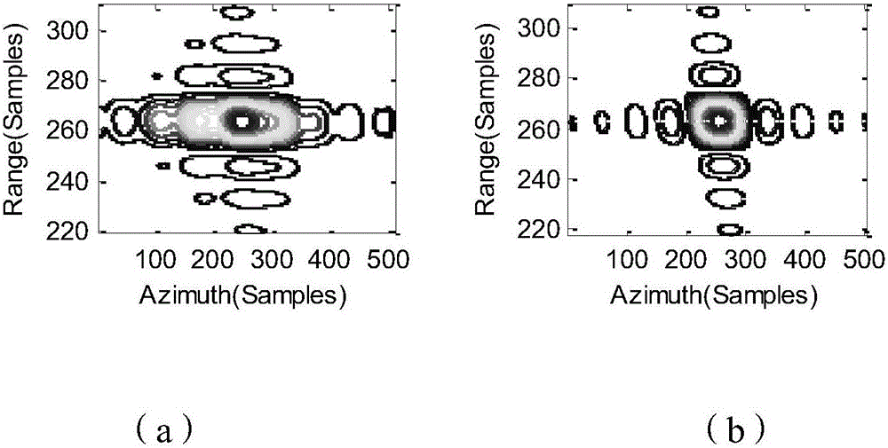
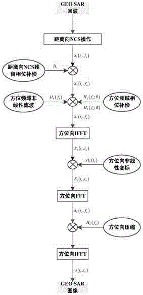
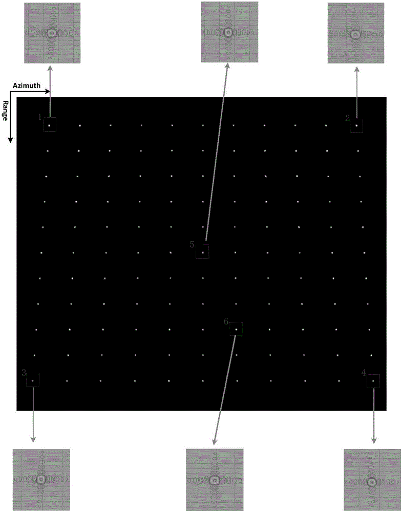
[0059] The present invention provides a two-dimensional nonlinear frequency modulation method for geosynchronous orbit SAR imaging. The present invention first establishes a GEOSAR space-variable model, in which the focusing parameter in SAR imaging processing, that is, the history of the slant range of the radar, is considered. The quadratic changes of the second-order coefficients in the range and azimuth directions in the fourth-order Taylor series expansion, and the linear changes of the third-order coefficients in the azimuth direction, and then the range and azimuth NCS imaging processing and azimuth NCS imaging are carried out according to the spatial variation model. processing, such as figure 1 shown, including the following steps:

[0060] Step 1. Establish the GEOSAR air variation model

[0061] The working mode of SAR is a "Stop-and-go" mo...


PUM


Abstract

The invention discloses a two-dimensional non-linear frequency conversion and modulation method for SAR imaging of a geosynchronous orbit. By means of the two-dimensional non-linear frequency conversion and modulation method, imaging processing of GEO SAR large-scale scene echoes can be effectively completed. According to the two-dimensional non-linear frequency conversion and modulation method, firstly, a GEO SAR space variation model is established, wherein focusing parameters, namely secondary changes of the second-order coefficient in the distance direction and the azimuth direction during slope distance history 4-order Taylor series expansion of a radar and linear changes of the third-order coefficient in the azimuth direction, in the SAR imaging processing process are considered in the model; secondly, NCS imaging processing in the distance direction and NCS imaging processing in the azimuth direction are conducted according to the space variation model. Compared with the prior art, by means of the two-dimensional non-linear frequency conversion and modulation method, imaging processing of the GEO SAR large-scale scene echoes can be effectively completed, phase errors, caused by two-dimensional space variation of the parameters, in the azimuth direction are eliminated, accurate focusing in the azimuth direction can be completed, and imaging of the GEO SAR large-scale scene (400 km * 400 km) can be realized.

Description

technical field [0001] The invention relates to the technical field of synthetic aperture radar imaging, in particular to a two-dimensional nonlinear frequency modulation method for geosynchronous orbit SAR imaging. Background technique [0002] Geosynchronous Orbit Synthetic Aperture Radar (GEOSAR) is a Synthetic Aperture Radar (SAR) system operating on satellites in geosynchronous orbit at an altitude of 36,000km above the ground. Since GEOSAR can cover an area of ​​more than 1000km, and the revisit period for key areas can be less than 1 day, GEOSAR has great practical value in land detection, soil moisture detection, atmospheric water vapor mapping, and surface deformation detection. [0003] Due to the high orbital height of GEOSAR, non-zero eccentricity, small satellite velocity, long synthetic aperture time, and large observation range, the imaging focusing parameters have not only distance-to-space variability, but also azimuth-to-space variability, so effective Ima...

Claims


Application Information

Patent Timeline
Patent Type & Authority Patents(China)
IPC IPC(8): G01S13/90
CPCG01S13/904G01S13/9004G01S13/9058
Inventor 丁泽刚曾涛李延倪崇刘大成佟川
Owner BEIJING INSTITUTE OF TECHNOLOGYGY
Why Eureka
Try Eureka