
Geographic information model and building information model integrated associated index component method

A technology of building information model and geographic information, which is applied in the field of integrated associative index components of geographic information model and building information model, can solve the problem of missing building data information, building data information cannot be used correctly and accurately, application scope and particle accuracy restrictions, etc.

Inactive Publication Date: 2014-06-25
SHANGHAI BLUE EARTH TECH CO LTD
View PDF4 Cites 19 Cited by
  • Summary
  • Abstract
  • Description
  • Claims
  • Application Information

AI Technical Summary

Problems solved by technology

In the process of simplifying the building information model, a large amount of building data information is lost, so that the building data information cannot be used correctly and accurately, and its application range and granular precision are also greatly limited

Method used


Image

  • Geographic information model and building information model integrated associated index component method

Examples


Embodiment Construction

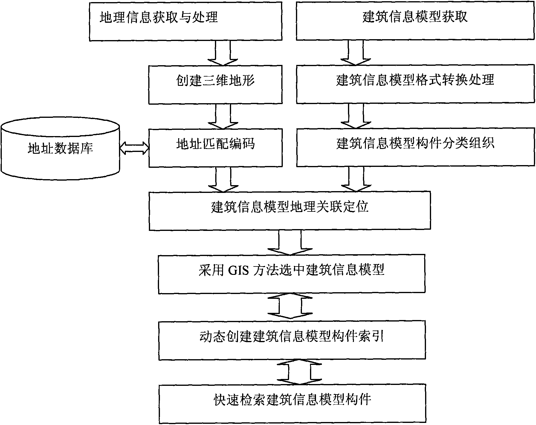
[0026] Such as figure 1 As shown, an integrated correlation index component method of geographic information model and building information model is characterized in that it includes geographic information acquisition and processing module, three-dimensional terrain creation module, address matching coding module, building information model acquisition and processing module, building The information model component classification and organization module, the building information model geographic association positioning module, the dynamic creation building information model component index module and the fast retrieval building information model component module include the following steps:

[0027] (1) Acquisition and processing of geographic information: acquire geographic information through remote sensing images, digital elevation models, and topographic maps;

[0028] (2) Create 3D terrain: use remote sensing images, digital elevation models, and topographic map data to c...


PUM


Abstract

The invention discloses a geographic information model and building information model integrated associated index component method, and belongs to the technical field of information.

Description

technical field [0001] The invention relates to the field of information technology, in particular to a method for an integrated associated index component of a geographic information model and a building information model. Background technique [0002] Human beings have two basic states: one is in the house; the other is on the way to another house; on the way, information services are provided by the geographic information system (GIS), and the best solution for carrying out information services indoors is based on building information Modeling (BIM) provides interior information services. With the development of human society, people have gone through primitive maps, paper maps, electronic maps, geographic information systems, and spatial information systems in the way of using geographic information, and are now entering the era of space-time information systems. Humans have never stopped exploring geographic space. The steps of information application. At the same tim...

Claims


Application Information

Patent Timeline
Patent Type & Authority Applications(China)
IPC IPC(8): G06F17/30G06T17/05
CPCG06F16/29G06T17/05
Inventor 陈根宝张恒张迅杰
Owner SHANGHAI BLUE EARTH TECH CO LTD
Learn More