GNSS data signal quality monitor method

A data signal and quality technology, applied in the field of satellite navigation, can solve the problems of monitoring data accuracy and completeness, data quality, difficult GNSS data signal monitoring, etc.

Inactive Publication Date: 2014-07-02
CHINESE ACAD OF SURVEYING & MAPPING
View PDF5 Cites 27 Cited by
  • Summary
  • Abstract
  • Description
  • Claims
  • Application Information

AI Technical Summary

Problems solved by technology

[0006] However, for the above-mentioned GNSS data signal quality monitoring, the accuracy and completeness of the monitoring data still have deficiencies in data quality, and it is difficult to effectively, accurately and real-time monitor the GNSS data signal quality

Method used


Image

  • GNSS data signal quality monitor method
  • GNSS data signal quality monitor method
  • GNSS data signal quality monitor method

Examples


Embodiment Construction

[0047] In order to make the object, technical solution and advantages of the present invention clearer, the present invention will be further described in detail below in conjunction with the accompanying drawings.

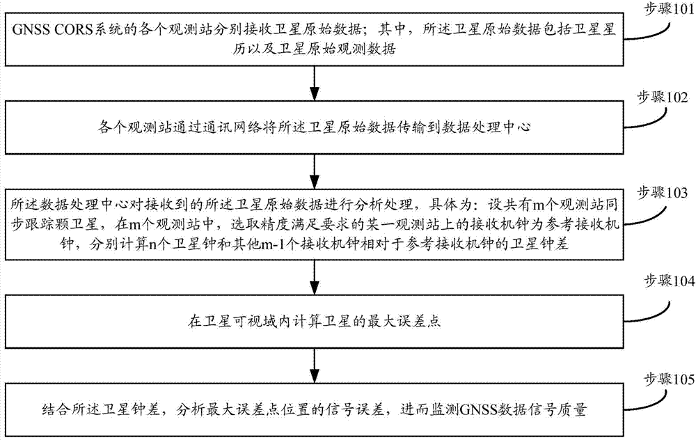
[0048] Such as figure 1 Shown, the monitoring method of the GNSS data signal quality provided by the present invention may further comprise the steps:

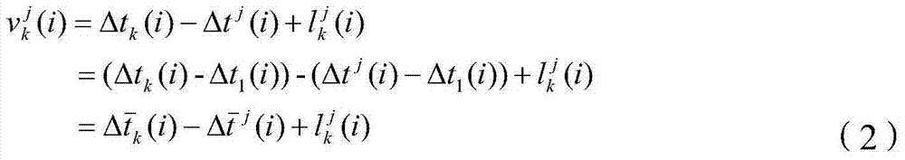
[0049] Step 101, each observation station of the GNSS CORS system receives satellite raw data respectively; wherein, the satellite raw data includes satellite ephemeris and satellite raw observation data; the observation station is a CORS station, on which a receiver is set;

[0050] GNSS CORS (Continuous Operational Reference System, abbreviated as CORS) system is a continuous operation satellite positioning service comprehensive system established by using multi-base station network technology. CORS stations are distributed within the working range covered by the network, and each CORS station acts as an indepe...


PUM


Abstract

The invention provides a GNSS data signal quality monitor method. The GNSS data signal quality monitor method includes the steps that every observation station receives original satellite data and transmits the original satellite data to a data processing center via a communication network; the data processing center calculates the satellite clock error of n satellite clocks and other (m-1) receiver clocks relative to a reference receiver clock; the maximum error point of a satellite is calculated within the visible range of the satellite; the signal error of the maximum error point position is analyzed according to the satellite clock error, and then the GNSS data signal quality is monitored. According to the GNSS data signal quality monitor method, when the GNSS data signal quality is monitored, the satellite clock error accuracy, space signal forecast accuracy and space data signal quality monitor accuracy are monitored in real time, and as the accuracy is compared with a threshold value and is monitored and issued in real time, the GNSS data signal quality can be monitored in real time.

Description

technical field [0001] The invention belongs to the technical field of satellite navigation, and in particular relates to a monitoring method for GNSS data signal quality. Background technique [0002] GNSS (Global Navigation Satellite System, Global Navigation Satellite System) has been widely used in military and civilian fields. Due to its characteristics of precision, real-time, and no geographical restrictions, it has become a general navigation tool in land transportation, navigation and aviation. [0003] Accurate evaluation of GNSS data and signal quality is not only a prerequisite for accurate judgment of the overall system accuracy, but also plays a very important role in system fault location and system optimization. GNSS signal quality monitoring can be divided into physical signal quality monitoring and data signal quality monitoring. The physical signal quality monitoring refers to the signal quality analysis of the original GNSS signal; the data signal qualit...

Claims


Application Information

Patent Timeline
Patent Type & Authority Applications(China)
IPC IPC(8): G01S19/08
CPCG01S19/08
Inventor 谷守周秘金钟方书山王世进李鹤峰
Owner CHINESE ACAD OF SURVEYING & MAPPING
Why Eureka
Try Eureka