A Method for Determining Positioning Accuracy of Optical Remote Sensing Satellite Images

A technology of satellite imagery and optical remote sensing, which is applied in the direction of measuring devices and instruments, and can solve the problem that the positioning accuracy cannot be quantified and designed

Active Publication Date: 2016-07-27
BEIJING INST OF SPACECRAFT SYST ENG
View PDF4 Cites 1 Cited by
  • Summary
  • Abstract
  • Description
  • Claims
  • Application Information

AI Technical Summary

Problems solved by technology

[0005] Problems solved by the present invention: Overcoming the deficiencies in the prior art, a method for determining the positioning accuracy of optical remote sensing satellite images is proposed, which decomposes and quantifies the positioning accuracy indicators into the design indicators of each satellite system, and solves the problem that the positioning accuracy is affected by various factors. However, in the satellite design, it is impossible to quantify the design problem. After the satellite design is determined, the error difference decomposition of the positioning accuracy index can be carried out, so as to estimate the image positioning accuracy according to each error item, and guide the satellite to target the weak links that affect the positioning accuracy. Perfect the design

Method used


Image

  • A Method for Determining Positioning Accuracy of Optical Remote Sensing Satellite Images
  • A Method for Determining Positioning Accuracy of Optical Remote Sensing Satellite Images
  • A Method for Determining Positioning Accuracy of Optical Remote Sensing Satellite Images

Examples


Embodiment Construction

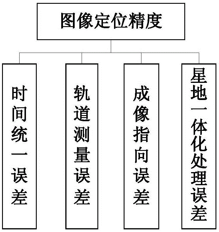
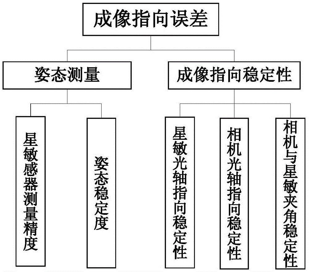
[0022] Such as figure 1 As shown, the image positioning accuracy of the present invention is decomposed into time unified error A, orbit measurement error B, imaging pointing error, and satellite-ground integration processing error.

[0023] The time unified error A is decomposed into the time transmission part error, the time transmission error and the time reception part error. At present, the time transmission part error of the remote sensing satellites in China is determined according to the time accuracy of the GPS hardware and obtained during the stand-alone test; the time transmission error is the signal transmission chain The transmission delay generated by the channel is obtained during the whole satellite test; the partial error of the time reception is determined by the processing time required by the single machine to process the second pulse signal, and obtained through single machine test and theoretical analysis. According to the current development status of typical...


PUM


Abstract

A determination method of optical remote sensing satellite image positioning accuracy. Influence factors of image positioning accuracy are classified into four classes, time unification error, track determination error, attitude determination error, and imaging pointing error. Based on current situation of remote sensing satellite design and development in our country, error terms are factorized grade by grade from systems to subsystems. The factorized error terms respectively correspond to links of satellite design, and thus influence factors of satellite image positioning accuracy are quantified into satellite design indexes. Through analysis of the influence factors of image positioning accuracy, index factorization and quantification, suggestions on error distribution and error influence degree, as well as positioning accuracy index calculation methods are provided in the satellite design protocol stage based on current situation of remote sensing satellite development in our country, and pre-estimate of satellite positioning accuracy is completed, thereby guiding the design of satellite image positioning accuracy.

Description

Technical field [0001] The invention relates to an index determination method in the design of an optical remote sensing satellite, in particular to a method for determining the positioning accuracy of an optical remote sensing satellite image. Background technique [0002] Image positioning accuracy is an important indicator that determines the practical value of optical remote sensing satellite images. The positioning accuracy of some foreign commercial remote sensing satellites has reached the meter level. For example, the positioning accuracy of GeoEye is about 6 meters. The kilometer positioning accuracy has been greatly improved to the current tens of meters of the Ziyuan-3 satellite, but there is still a certain gap between the meter-level positioning accuracy of foreign optical remote sensing satellites. [0003] The accuracy of image positioning is an index of world-earth integration, which is related to both the satellite system and the ground system. For the satellite s...

Claims


Application Information

Patent Timeline
Patent Type & Authority Patents(China)
IPC IPC(8): G01C25/00
CPCG01C25/00
Inventor 关晖郭倩蕊贾宏杜辉赵晨光张强刘红雨
Owner BEIJING INST OF SPACECRAFT SYST ENG
Why Eureka
Try Eureka