Method and device for modifying boundary of geologic model

A geological model and boundary technology, applied in 3D modeling, image data processing, instruments, etc., can solve the problem that the boundary model loses its original shape

Active Publication Date: 2014-08-06
CHINA PETROLEUM & CHEM CORP +1
View PDF3 Cites 3 Cited by
  • Summary
  • Abstract
  • Description
  • Claims
  • Application Information

AI Technical Summary

Problems solved by technology

Since the naked eye cannot accurately identify the positioning point P to completely match the line segment BC, the modified new boundary curve ABPCDE is not compl...

Method used


Image

  • Method and device for modifying boundary of geologic model
  • Method and device for modifying boundary of geologic model
  • Method and device for modifying boundary of geologic model

Examples


Embodiment 1

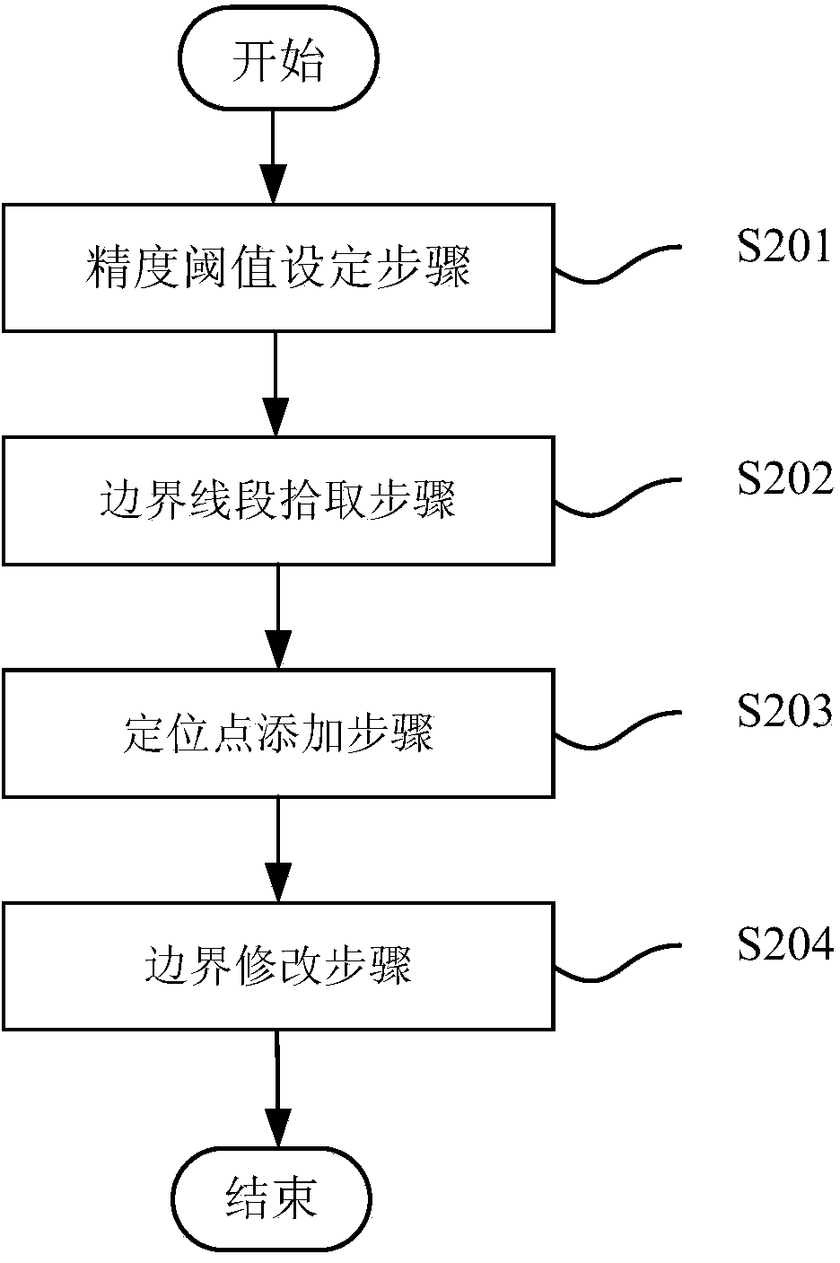
[0037] figure 2 It is a flow chart of the geological model boundary modification method in Embodiment 1 of the present invention. Include the following steps:

[0038] Step S201, the accuracy threshold setting step, setting the distance threshold from the positioning point to be added to the boundary line segment;

[0039] Step S202, the boundary line segment picking step, captures the position information of the positioning point to be added specified by the human-computer interaction device, and picks the boundary line segment according to the distance threshold and the position information of the positioning point to be added;

[0040] Step S203, the step of adding an anchor point, determining a fidelity anchor point on the picked boundary line segment, and using the position of the fidelity anchor point as the adding position of the anchor point to be added.

[0041] Preferably, the method provided in this embodiment also includes:

[0042] Step S204, boundary modifyin...

Embodiment 2

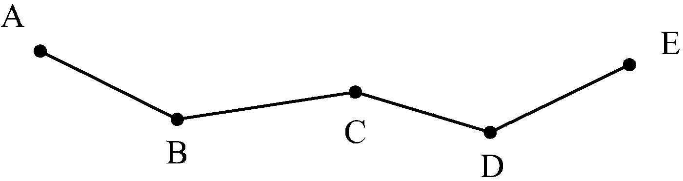
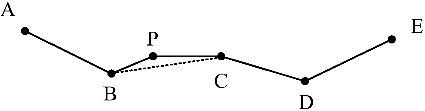
[0044] image 3 It is a flow chart of the geological model boundary modification method in the second embodiment of the present invention. The method provided in this embodiment is used to modify the two-dimensional polygon boundary in the existing three-dimensional geological model, such as Figure 4 As shown, the curve ABCDE is a part of the polygon boundary representing a certain two-dimensional geological region, including several boundary line segments AB, BC, CD, DE.

[0045] The method includes the following steps.

[0046] Step S301, the accuracy threshold setting step, setting the distance threshold L between the positioning point to be added and the boundary line segment.

[0047] Step S302, the boundary line segment picking step, captures the position information of the positioning point to be added designated by the human-computer interaction device, and picks the boundary line segment according to the distance threshold and the position information of the positi...

Embodiment 3

[0067] Figure 5 It is a schematic diagram of the geological model boundary modifying device according to the second embodiment of the present invention. The geological model boundary modifying device 500 provided in this embodiment includes the following modules.

[0068] The accuracy threshold setting module 501 is configured to set a distance threshold between the positioning point to be added and the boundary line segment.

[0069] The boundary line segment picking module 502 is used to capture the position information of the positioning point to be added specified by the human-computer interaction device, and pick up the boundary line segment according to the distance threshold and the position information of the positioning point to be added; specifically, the boundary line segment picking module 502 The picking module calculates the distance from the positioning point to be added to the boundary line segment according to the location information of the positioning poin...


PUM


Abstract

The invention discloses a method and device for modifying the boundary of a geologic model. The method comprises the steps that a precision threshold value is set, and the distance threshold value of a locating point to be added and a boundary segment is set; the boundary segment is picked up, the location information of the locating point, to be added, specified by a man-machine interaction device is captured, and the boundary segment is picked up according to the distance threshold value and the location information of the locating point to be added; the locating point is added, the fidelity locating point is determined on the picked boundary segment, and the position of the fidelity locating point is used as the adding position of the locating point to the added. According to the method and device, locating errors caused when the loading point is added to a boundary curve manually can be corrected, and therefore too great form distortion cannot happen to the geologic model.

Description

technical field [0001] The invention relates to the field of three-dimensional geological modeling, in particular to a method and device for modifying the boundary of a geological model. Background technique [0002] Three-dimensional geological modeling technology is an emerging technology that has emerged with the continuous development of computer technology in recent years. It combines geological theory and three-dimensional graphic visualization technology to conduct detailed research on underground oil and gas sedimentary reservoirs. [0003] In the process of 3D geological modeling, it is often necessary to edit and modify the existing model. At present, it is difficult to directly edit the complex 3D model interactively. Since the boundary marks the lateral extension of the 3D model, usually in the 2D interface Model the boundary, use the 2D model to create a new boundary and edit and modify it. Points and line segments are the basic geometric elements in the two-di...

Claims


Application Information

Patent Timeline
IPC IPC(8): G06T17/05
Inventor 宋志翔毕进娜宋祈真岳承琪魏嘉
Owner CHINA PETROLEUM & CHEM CORP
Why Eureka
Try Eureka