Interferential circular SAR elevation estimation processing method

A circular track and elevation technology, applied in the field of elevation estimation, to achieve the effect of realizing integrated, high-precision and high-resolution circular track SAR imaging and real-time circular track SAR imaging

Active Publication Date: 2014-08-27
INST OF ELECTRONICS CHINESE ACAD OF SCI
View PDF3 Cites 15 Cited by
  • Summary
  • Abstract
  • Description
  • Claims
  • Application Information

AI Technical Summary

Problems solved by technology

Existing research on circular interferometric SAR mainly includes three-dimensional imaging of small targets and estimation of the earth's surface ter...

Method used


Image

  • Interferential circular SAR elevation estimation processing method
  • Interferential circular SAR elevation estimation processing method
  • Interferential circular SAR elevation estimation processing method

Examples


Embodiment Construction

[0011] In order to make the object, technical solution and advantages of the present invention clearer, the present invention will be described in further detail below in conjunction with specific embodiments and with reference to the accompanying drawings.

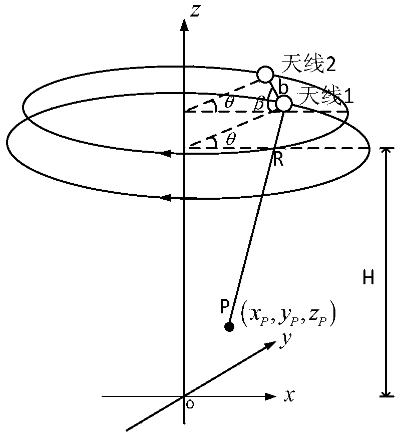
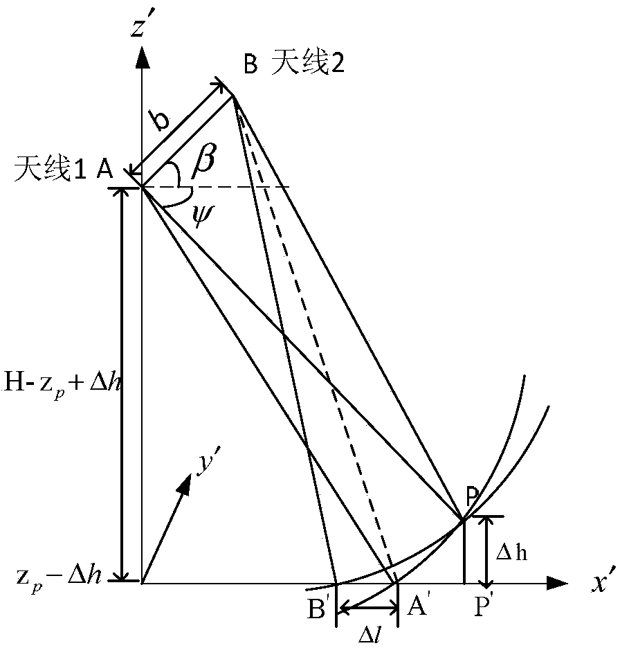
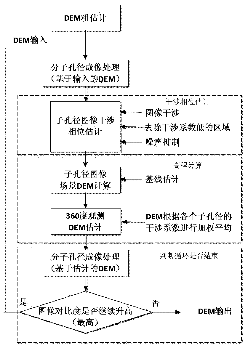
[0012] The invention proposes an interferometric SAR elevation estimation method. The concrete steps that this method comprises are as follows:

[0013] Step 1. Roughly estimate the scene DEM. In this step, the scene DEM can be roughly estimated by using the stereo image pair measurement method.

[0014] Circular SAR has three-dimensional imaging capabilities. When performing two-dimensional imaging, objects located outside the imaging reference plane will be projected to different positions on the imaging plane when observed at different azimuth angles. Perform measurements (see in detail Stephan Palm, Hélène M. Oriot, and Hubert M. Cantalloube. Radargrammetric DEM Extraction Over Urban Area Using Circular SAR Imagery....


PUM


Abstract

The invention discloses an interferential circular SAR elevation estimation processing method. The method comprises the steps that (1) a scene DEM is estimated roughly; (2) on the basis of the roughly estimated scene DEM, BP imaging is carried out on an InSAR platform main antenna and an InSAR platform auxiliary antenna respectively and independently, wherein BP imaging is carried out on circular SAR data obtained by the main antenna and the auxiliary antenna by adopting a molecule aperture mode, one sub aperture is set every n degrees, 360/n sub aperture image pairs are obtained, and n is a natural number larger than or equal to 1; (3) interference processing is carried out on each sub aperture image pair; (4) weighted average is carried out on the scene elevation, estimated through the interference processing, of all the sub aperture image pairs obtained in the step (3) according to the value of a corresponding interference coefficient, and an elevation map observed under 360 degrees is obtained; (5) the elevation map estimated in the step (4) is used as a reference DEM of the step (2) to be input, and the step (2) to the step (4 )are repeated for several times until the interference coefficient of interference images does not decline any more.

Description

technical field [0001] The invention relates to the technical field of elevation estimation, in particular to an interferometric circular SAR elevation estimation method. Background technique [0002] Synthetic Aperture Radar (SAR) has all-weather, all-weather, high-resolution large-area imaging capabilities, and has become an important tool for military and civilian purposes. Considering that under the imaging geometry of the traditional linear SAR mode, there are inherent deformation phenomena of SAR images due to overlapping, foreshortening and shadows, and the problem that only the backscattering of the observed object in a small range of directions can be obtained, in order to further improve the observation ability of SAR In the early 1990s, American scholars such as Knaell first proposed the concept of Circular Synthetic Aperture Radar (Circular SAR, CSAR). Since then, CSAR has been extensively studied because of its unique advantages. Under the observation geometry ...

Claims


Application Information

Patent Timeline
IPC IPC(8): G01S13/90
CPCG01S13/9023G01S13/9088
Inventor 刘燕林赟谭维贤洪文王彦平
Owner INST OF ELECTRONICS CHINESE ACAD OF SCI
Why Eureka
Try Eureka