Multi-scale superposition segmentation method

A multi-scale segmentation and multi-scale technology, applied in the field of satellite remote sensing monitoring, can solve the problems of neglected feature utilization, lack of correlation between land cover classification, unclear laws and mechanisms of changes in different land cover scales, etc. Effect

Inactive Publication Date: 2014-09-10
INST OF REMOTE SENSING & DIGITAL EARTH CHINESE ACADEMY OF SCI
View PDF3 Cites 8 Cited by
  • Summary
  • Abstract
  • Description
  • Claims
  • Application Information

AI Technical Summary

Problems solved by technology

[0006] At present, the research on land cover classification using multi-scale object-oriented methods is just in its infancy, and the research on the scale deduction of land cover image object features still faces the following problems: (1) Due to the heterogeneity of spectral and spatial characteristics of land cover types The law and mechanism of scale changes of different land covers are not clear, and a robust and standard scale selection method has not yet been formed; (2) The characteristics of scale changes have not been fully explored, Classification mainly relies on two-dimensional spectral and geometric features, ignoring the use of longitudinal features in the process of scale deduction; (3) There is no correlation between multi-scale land cover classifications, and the final composite classification results are time-consuming due to the overlap of the respective classification results. Error transmission is generated, and the effect of multi-type and multi-scale land cover is not ideal

Method used


Image

  • Multi-scale superposition segmentation method
  • Multi-scale superposition segmentation method
  • Multi-scale superposition segmentation method

Examples


Embodiment Construction

[0026] The following will clearly and completely describe the technical solution of the present invention in conjunction with the accompanying drawings of the present invention. Obviously, the described embodiments are only some of the embodiments of the present invention, not all of them. Based on the embodiments of the present invention, all other embodiments obtained by persons of ordinary skill in the art without making creative efforts belong to the protection scope of the present invention.

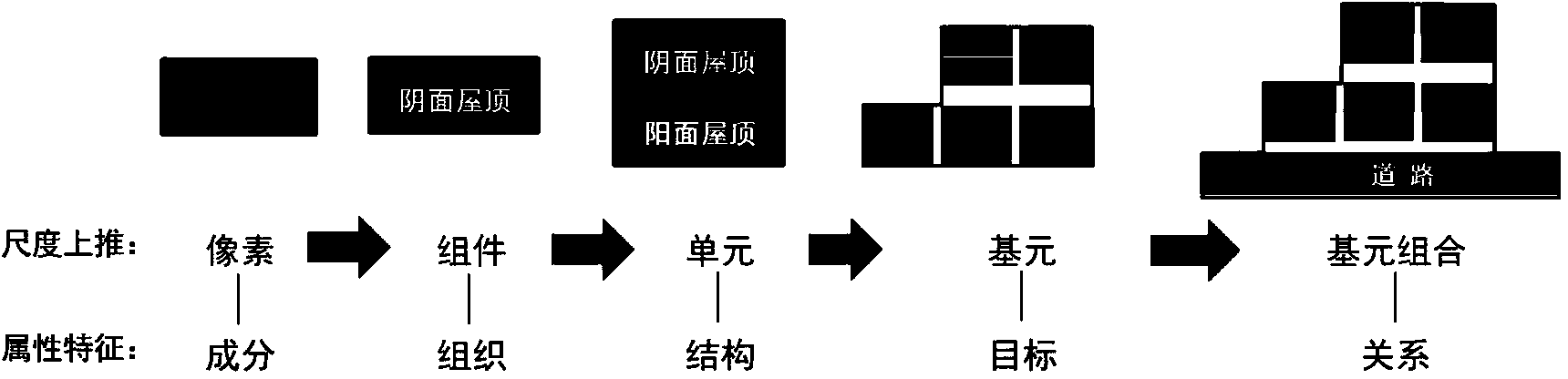
[0027] In the existing multi-scale segmentation, it is the process of turning pixels (raster) into objects (vectors). The purpose is to consider not only the spectral characteristics of the target, but also the shape, features such as spatial relationships, thereby improving classification accuracy. see below figure 1 , is a schematic diagram of the multi-scale segmentation process; the multi-scale segmentation process is a way to obtain multi-level pixel fusion by setting a scale ...


PUM


Abstract

The invention discloses a multi-scale superposition segmentation method, which comprises the following steps that: images are subjected to multi-scale segmentation to obtain each scale object after the segmentation; a stable scale index is utilized for judging each scale object to determine the optimum scale object of each scale; the determined optimum scale object of each scale is projected to a single data layer; and the optimum scale objects projected onto the single data layer are merged. The multi-scale superposition segmentation method has the advantages that the segmentation object extraction is carried out by using real ground object matching based on each object boundary as targets; the multi-scale segmentation on the images is realized; the problems of over-segmentation and under-segmentation of objects in the same scale but different land coverage types and the problem of overlapping during the multi-scale object superposition are avoided; and the precision of the multi-scale segmentation is improved.

Description

technical field [0001] The invention relates to the field of satellite remote sensing monitoring in geography, in particular to a multi-scale superposition and segmentation method. Background technique [0002] The spectral characteristics of remote sensing images greatly affect the accuracy of land cover mapping. Different land cover types themselves have a high degree of internal heterogeneity and inter-class similarity in spectral characteristics. Even high-resolution images often reduce the classification accuracy due to the phenomenon of "same spectrum and different objects". For traditional pixel-based, single The classification method of scale spectrum is difficult to solve the problem of classification accuracy. [0003] Scale effects refer to the translation of information at different spatial and temporal scales or at different organizational levels. Based on the scale space theory and the perspective of geoscience processes, patterns and processes often have diff...

Claims


Application Information

Patent Timeline
Patent Type & Authority Applications(China)
IPC IPC(8): G06T7/00G06T5/00
Inventor 张磊
Owner INST OF REMOTE SENSING & DIGITAL EARTH CHINESE ACADEMY OF SCI
Why Eureka
Try Eureka