Method for positioning between mobile terminals and mobile terminal using the same

A mobile terminal and initial position technology, applied in measuring devices, instruments, surveying and mapping, and navigation, etc., can solve the problems that the positioning method of the satellite navigation system needs to be improved, and achieve the effect of improving efficiency and accuracy

Inactive Publication Date: 2014-10-15
SAMSUNG GUANGZHOU MOBILE R&D CENT +1
View PDF7 Cites 17 Cited by
  • Summary
  • Abstract
  • Description
  • Claims
  • Application Information

AI Technical Summary

Problems solved by technology

[0005] Therefore, the positioning method relying on the sate

Method used


Image

  • Method for positioning between mobile terminals and mobile terminal using the same
  • Method for positioning between mobile terminals and mobile terminal using the same
  • Method for positioning between mobile terminals and mobile terminal using the same

Examples


Embodiment Construction

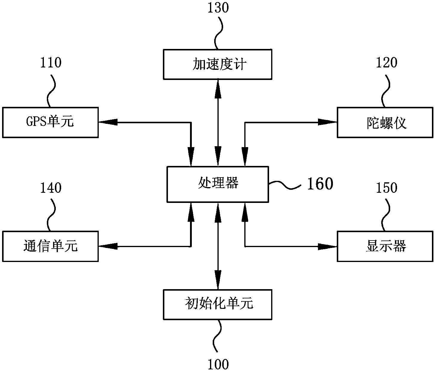
[0030] Hereinafter, embodiments of the present invention are described in more detail by referring to the accompanying drawings. In the following description, the mobile terminal adopts the commonly used GPS navigation technology as an example. However, the present invention is not limited to adopting the GPS navigation technology, and other types of navigation technologies may also be used, for example, Beidou navigation.

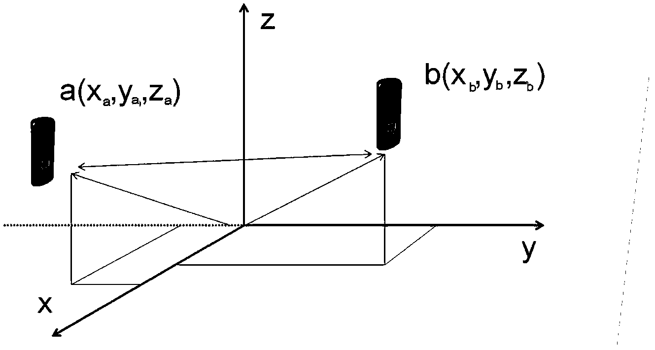
[0031] According to the technical idea of ​​the present invention, the positioning of the mobile terminal and the mutual positioning between the mobile terminals are realized by further including a gyroscope and an accelerometer in the mobile terminal including the GPS navigation unit.

[0032] The gyroscope in the mobile terminal of the present invention may adopt a three-axis gyroscope. The three-axis gyroscope can measure the angular velocity to judge the motion state of the mobile terminal, so as to judge the initial shape and the state after the rotat...


PUM


Abstract

The invention provides a method for positioning between mobile terminals and a mobile terminal using the same. The mobile terminal comprises an initialization unit for initially positioning the mobile terminal to obtain an initial position and an initial rate of the mobile terminal, a gyroscope for respectively measuring rotation angles of the mobile terminal around a X shaft, a Y shaft and a Z shaft, an accelerometer for acquiring a movement accelerated speed of the mobile terminal, a processor for determining the current position of the mobile terminal in real time by the rotation angles detected by the gyroscope and an accelerated speed detected by the accelerometer according to the initial position and the initial rate, and a communication module for communicating with other mobile terminals and acquiring position information of other mobile terminals in real time, wherein the position of the processor and position information of other mobile terminals are displayed by a display under the control of the processor.

Description

technical field [0001] The invention relates to a positioning method between mobile terminals and a mobile terminal adopting the method. Background technique [0002] In daily life, navigation technologies such as satellite navigation systems (for example, GPS (Global Positioning System), Beidou Navigation) are more and more widely used in daily life, ranging from self-driving tours to shopping, and travel for human life. Provides great convenience. With the improvement of living standards, mobile terminals such as mobile phones have become one of the necessary items that people carry with them, and satellite navigation systems have also become one of the necessary functions of the mobile terminals. [0003] Taking the GPS navigation unit as an example, under certain environmental conditions (for example, indoors or in bad weather, on a mountain road or in a tunnel), the GPS signal will become weak or the GPS signal will not be received, causing the GPS function to fail. i...

Claims


Application Information

Patent Timeline
IPC IPC(8): G01C21/00
CPCG01C21/165
Inventor 刘奇峰梁世龙
Owner SAMSUNG GUANGZHOU MOBILE R&D CENT
Why Eureka
Try Eureka