Multi-source distribution type remote sensing distinguishing method and system for geothermal resources

A geothermal resource and distributed technology, applied in the field of remote sensing technology and application, can solve the problems that remote sensing image data cannot mutually verify the recognition accuracy and the application effect is not ideal

Active Publication Date: 2014-10-29
INST OF MINERAL RESOURCES CHINESE ACAD OF GEOLOGICAL SCI +1
View PDF2 Cites 23 Cited by
  • Summary
  • Abstract
  • Description
  • Claims
  • Application Information

AI Technical Summary

Problems solved by technology

[0004] The present invention aims at the prior art by combining geological interpretation and temperature interpretation of multi-spectral remote sensing image data to carry out remote sensing research on geothermal resources, only the fault structure on the surface can be obtained, resulting in unsatisfactory application effect and mutual verification of remote sensing image data. As well as the problem of low identification accuracy, a multi-source distributed remote sensing identification method for geothermal resources is provided, and the accurate identification of geothermal resources is realized through the processing, interpretation and integration of multi-source remote sensing image data

Method used


Image

  • Multi-source distribution type remote sensing distinguishing method and system for geothermal resources
  • Multi-source distribution type remote sensing distinguishing method and system for geothermal resources
  • Multi-source distribution type remote sensing distinguishing method and system for geothermal resources

Examples


Embodiment Construction

[0034] The present invention will be described below in conjunction with the drawings.

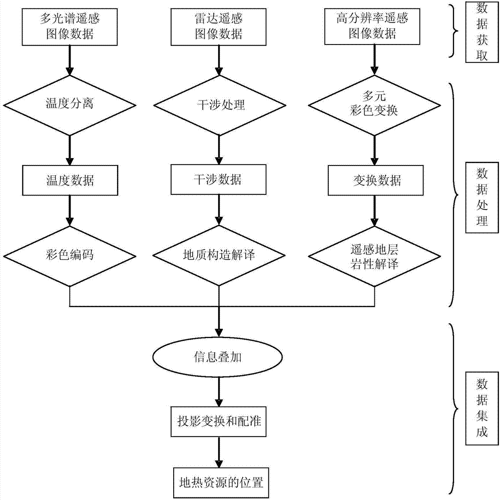
[0035] The invention relates to a multi-source distributed remote sensing discrimination method for geothermal resources. The process of the method is as follows figure 1 Shown, including the following steps:

[0036] The data acquisition step is used for acquiring multi-source remote sensing image data, the multi-source remote sensing image data including multi-spectral remote sensing image data, radar remote sensing image data, and high-resolution remote sensing image data. Among them, multi-spectral remote sensing image data such as ASTER remote sensing image data can choose winter data with no clouds, no snow, less vegetation, and little temperature difference between day and night; radar remote sensing image data such as PALSAR radar remote sensing image data, can choose a pair of radars Data, the data with smaller horizontal and vertical baselines; high-resolution remote sensing image dat...


PUM


Abstract

The invention relates to a multi-source distribution type remote sensing distinguishing method and system for geothermal resources. The multi-source distribution type remote sensing distinguishing method for the geothermal resources comprises a data acquisition step which is used for obtaining multi-source remote sensing images; a data processing step which comprises performing color coding and mapping processing on multispectral remote sensing image data through a temperature and emissivity separation algorithm to obtain temperature color coding image information; establishing a geologic structure interpretation sign of the geothermal resources for radar remote sensing image data and performing geologic structure interpretation on the radar remote sensing image data; a data integration step, namely performing superposition, projection transformation and rectification on three routes of information obtained from the data processing step, integrating to obtain positions of the geothermal resources and achieving multi-source distribution type remote sensing distinguishing of the geothermal resources. The multi-source distribution type remote sensing distinguishing method for the geothermal resources achieves accurate distinction of the geothermal resources due to processing, interpretation and integration of the multi-source remote sensing image data.

Description

Technical field [0001] The invention relates to the field of remote sensing technology and application, in particular to a multi-source distributed remote sensing discrimination method and system suitable for geothermal resources. Background technique [0002] Geothermal resources are a new type of energy and resource that can be regenerated and reused. It is generally believed that geothermal resources originate from the lava and the decay of radioactive elements in the deep earth. Groundwater circulation, capillary action, fractures, magmatic activity, etc. can bring heat energy from the underground to the surface, forming a thermal gradient on the surface and a certain depth of the underground. The parameters of the thermal emissivity and temperature of the surface material detected by thermal infrared remote sensing technology are used to use heat. The temperature and emissivity separation algorithm of infrared remote sensing can quickly detect the surface temperature, and th...

Claims


Application Information

Patent Timeline
Patent Type & Authority Applications(China)
IPC IPC(8): G06K9/62G06T7/00
Inventor 姚佛军邵争平焦鹏程齐志龙刘雷震
Owner INST OF MINERAL RESOURCES CHINESE ACAD OF GEOLOGICAL SCI
Why Eureka
Try Eureka