Supercharge Your Innovation With Domain-Expert AI Agents!

Algorithm for improving vehicle-mounted laser scanning data by introducing control points

A technology of vehicle-mounted laser scanning and scanning data, applied in the field of surveying and mapping, can solve the problems of inability to meet the requirements of surveying and mapping tasks, large errors in point cloud coordinates, etc., and achieve the effect of reliable results and reasonable parameters

Active Publication Date: 2014-12-31
浙江四维远见信息技术有限公司
View PDF5 Cites 9 Cited by
  • Summary
  • Abstract
  • Description
  • Claims
  • Application Information

AI Technical Summary

Problems solved by technology

[0002] Due to the influence of GPS signal, POS system drift, LIDAR system ranging accuracy, driving stability and other factors, the vehicle-mounted laser scanning system makes the calculated point cloud coordinates contain large errors, which cannot meet the requirements of the surveying and mapping task.

Method used


Image

  • Algorithm for improving vehicle-mounted laser scanning data by introducing control points

Examples


Embodiment Construction

[0017] The technical solutions in the embodiments of the present invention will be clearly and completely described below in conjunction with the accompanying drawings in the embodiments of the present invention. Obviously, the described embodiments are only a part of the embodiments of the present invention, rather than all the embodiments. The embodiments of the present invention and all other embodiments obtained by those of ordinary skill in the art fall within the protection scope of the present invention.

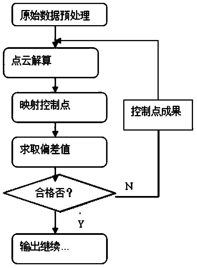
[0018] Such as figure 1 As shown, this embodiment provides an algorithm for introducing control points to improve vehicle-mounted laser scanning data. The algorithm includes the following steps:

[0019] Obtain scan data of the measured object through the vehicle-mounted laser scanning device;

[0020] Collect the data of the set control point;

[0021] Calculate the acquired scan data of the measured object to the point cloud data of the set coordinate system, and map the c...


PUM


Abstract

The invention provides an algorithm for improving vehicle-mounted laser scanning data by introducing control points. The algorithm comprises the following steps: obtaining scanning data of a measured object through a vehicle-mounted laser scanning device; acquiring data of the set control points; resolving the obtained scanning data of the measured object to point cloud data of a set coordinate system, and during resolving, mapping a resolved point to the acquired data of the control points; working out a deviation value of the resolved point and the acquired data of the control points; judging whether the deviation value meets the set requirements or not, if so, outputting the resolved point, and if not, resolving point cloud again. The algorithm has the benefits that the problems of check shortage due to direct resolving by the scanning data, non precision evaluation and low positioning precision caused by POS (point of sale) drift in long-time scanning operation are solved; a conventional measurement adjustment theory is transplanted for point cloud adjustment, results are reliable, parameters are reasonable, and the precision can be manually controlled according to the density, distribution, measurement precision and the like of the control points.

Description

Technical field [0001] The invention relates to the technical field of surveying and mapping, in particular to an algorithm for introducing control points to improve vehicle-mounted laser scanning data. Background technique [0002] The vehicle-mounted laser scanning system is affected by factors such as GPS signal, POS system drift, LIDAR system ranging accuracy, driving stability and other factors, so that the calculated point cloud coordinates contain large errors and cannot meet the requirements of surveying and mapping tasks. [0003] For the problems in related technologies, no effective solutions have yet been proposed. Summary of the invention [0004] Aiming at the problems in the related art, the present invention proposes an algorithm for introducing control points to improve vehicle-mounted laser scanning data to solve the above-mentioned problems. [0005] The technical scheme of the present invention is realized as follows: [0006] The present invention provides an algo...

Claims


Application Information

Patent Timeline
IPC IPC(8): G01B11/00
Inventor 马浩左建章关艳玲杨铁利魏占营王留召
Owner 浙江四维远见信息技术有限公司
Features
  • R&D
  • Intellectual Property
  • Life Sciences
  • Materials
  • Tech Scout
  • Unparalleled Data Quality
  • Higher Quality Content
  • 60% Fewer Hallucinations
Learn More