Supercharge Your Innovation With Domain-Expert AI Agents!

An Algorithm for Improving Vehicular Laser Scanning Data by Introducing Control Points

A technology of vehicle-mounted laser scanning and scanning data, applied in the field of surveying and mapping, can solve the problems of inability to meet the requirements of surveying and mapping tasks, large errors in point cloud coordinates, etc., and achieve the effect of reliable results and reasonable parameters

Active Publication Date: 2017-09-19
浙江四维远见信息技术股份有限公司
View PDF5 Cites 0 Cited by
  • Summary
  • Abstract
  • Description
  • Claims
  • Application Information

AI Technical Summary

Problems solved by technology

[0002] Due to the influence of GPS signal, POS system drift, LIDAR system ranging accuracy, driving stability and other factors, the vehicle-mounted laser scanning system makes the calculated point cloud coordinates contain large errors, which cannot meet the requirements of the surveying and mapping task.

Method used


Image

  • An Algorithm for Improving Vehicular Laser Scanning Data by Introducing Control Points

Examples


Embodiment Construction

[0017] The following will clearly and completely describe the technical solutions in the embodiments of the present invention with reference to the accompanying drawings in the embodiments of the present invention. Obviously, the described embodiments are only some, not all, embodiments of the present invention. The embodiments of the present invention and all other embodiments obtained by those skilled in the art belong to the protection scope of the present invention.

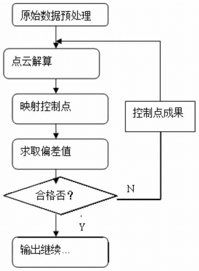
[0018] Such as figure 1 As shown, this embodiment provides an algorithm for introducing control points to improve vehicle-mounted laser scanning data, and the algorithm includes the following steps:

[0019] Obtain the scanning data of the measured object through the vehicle-mounted laser scanning device;

[0020] Collect the data of the set control points;

[0021] Calculate the scanned data of the measured object to the point cloud data of the set coordinate system, and map the calculated points to the da...


PUM


Abstract

The invention provides an algorithm for introducing control points to improve vehicle-mounted laser scanning data. The algorithm includes the following steps: acquiring the scanning data of the measured object through the vehicle-mounted laser scanning device; collecting the data of the set control points; and converting the acquired measured object The scan data is solved to the point cloud data of the set coordinate system, and when solving, the solved points are mapped to the data of the collected control points; the relationship between the solved points and the data of the collected control points is obtained. Deviation value; determine whether the deviation value meets the set requirements. If it meets the requirement, the calculated point will be output. If it does not meet the requirement, the point cloud will be recalculated. The beneficial effects of this invention are: solving the problems of reduced positioning accuracy due to lack of verification, inability to evaluate accuracy, and POS drift in long-term scanning operations due to direct calculation using scanned data; transplanting traditional measurement adjustment theory to perform point cloud adjustment, The results are reliable, the parameters are reasonable, and the accuracy can be manually controlled depending on the density, distribution, and measurement accuracy of the control points.

Description

technical field [0001] The invention relates to the technical field of surveying and mapping, in particular to an algorithm for introducing control points to improve vehicle-mounted laser scanning data. Background technique [0002] Due to the influence of GPS signal, POS system drift, LIDAR system ranging accuracy, driving stability and other factors, the vehicle-mounted laser scanning system makes the calculated point cloud coordinates contain large errors, which cannot meet the results of surveying and mapping tasks. [0003] Aiming at the problems in the related technologies, no effective solution has been proposed yet. Contents of the invention [0004] Aiming at the problems in the related technologies, the present invention proposes an algorithm for introducing control points to improve vehicle-mounted laser scanning data, so as to solve the above problems. [0005] Technical scheme of the present invention is realized like this: [0006] The invention provides an...

Claims


Application Information

Patent Timeline
Patent Type & Authority Patents(China)
IPC IPC(8): G01B11/00
Inventor 杨铁利郏卫萍左建章陈学霞宋红霞
Owner 浙江四维远见信息技术股份有限公司
Features
  • R&D
  • Intellectual Property
  • Life Sciences
  • Materials
  • Tech Scout
  • Unparalleled Data Quality
  • Higher Quality Content
  • 60% Fewer Hallucinations
Learn More