Three-dimensional terrain model rendering method

A 3D terrain and model technology, applied in the field of 3D simulation, can solve problems such as heavy workload and cumbersome process, achieve the effects of reducing difficulty, efficient rendering engine, and improving organization and rendering efficiency

Inactive Publication Date: 2015-01-21
长江岩土工程有限公司
View PDF2 Cites 7 Cited by
  • Summary
  • Abstract
  • Description
  • Claims
  • Application Information

AI Technical Summary

Problems solved by technology

[0003] The purpose of the present invention is to overcome the shortcomings of the above-mentioned background technology, provide a rendering method of a three-dimensional terrain model, and solve the problems of heavy workload and cumbersome process in traditional rendering methods

Method used


Image

  • Three-dimensional terrain model rendering method

Examples


Embodiment Construction

[0016] The present invention will be described in further detail below in conjunction with the accompanying drawings and embodiments, but these embodiments should not be construed as limiting the present invention.

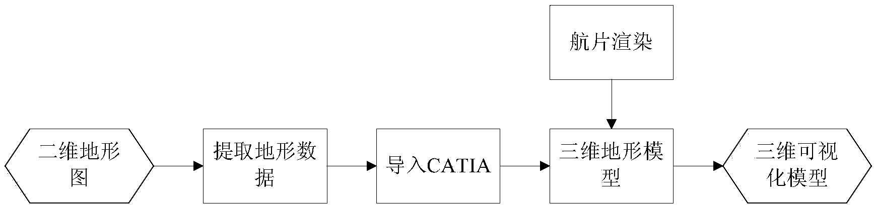
[0017] see figure 1 , the rendering method of the three-dimensional terrain model of the present invention, comprises the following steps:

[0018] Step 1, the CAD topographic map contour and elevation point data are extracted by the engineering geological information database management system, and an ASCii free format file is generated. The engineering geological information database management system has been registered for copyright, and the copyright holders are respectively Changjiang Geotechnical Engineering General Manager The company (Wuhan) and Central South University, the version number is V1.0, the development completion date is February 7, 2014, and the registration number is 2014SR070463. The engineering geological information database management sy...


PUM


Abstract

The invention discloses a three-dimensional terrain model rendering method. The method includes the following steps that first, data of contour lines and elevation points of a two-dimensional topographic map are extracted through a secondary development tool, and a standard code format file of a computer is generated; second, the topographic data are input into three-dimensional modeling software, and topographic point cloud data are generated; third, a topographic curved surface is generated through the topographic point cloud data, and a boss is established within the topographic range; fourth, the topographic curved surface and the boss are subjected to partition or Boolean calculation, and a topographic three-dimensional model is established; fifth, computer development languages are adopted for secondary development, aerial photos are fast compressed according to coordinates and automatically spliced, and then the topographic three-dimensional model is subjected to rendering; sixth, the three-dimensional visualization model of a large scale terrain environment is generated. The method solves the problems that a traditional rending mode is large in workload and tedious in process and can be widely applied to the technical field of three-dimensional simulation.

Description

technical field [0001] The invention relates to the technical field of three-dimensional simulation, in particular to a rendering method of a three-dimensional terrain model. Background technique [0002] For a long time, the analysis and interpretation results of geographic information system data have been limited to two-dimensional static representations. Traditional topographic maps use two-dimensional plane symbols, characters, numbers, etc. to condense objective geographical entities, and use two-dimensional plane maps to represent geospatial information. It reflects the plane geometric information of various geographical entities, and in reality, various geographical entities exist in three-dimensional form. Therefore, it is difficult for traditional two-dimensional topographic maps to express the real world intuitively. It is helpful for people to understand the terrain clearly and completely. The terrain and topographic conditions have caused difficulties and limite...

Claims


Application Information

Patent Timeline
Patent Type & Authority Applications(China)
IPC IPC(8): G06T15/00G06T17/00
CPCG06T15/205G06T17/05G06T2200/04
Inventor 郭麒麟韩旭冯明权向能武杨汉良徐俊冯建元易名龙林仕祥黄振伟邓争荣李爱国尹春明侯钦礼杨友刚张少锋於汝山殷先松郑新冉隆田
Owner 长江岩土工程有限公司
Why Eureka
Try Eureka