Rectangular region based method for quickly positioning roads bus points belong to

A technology for bus vehicles and bus lines, applied in the field of intelligent transportation, can solve problems such as poor accuracy, failure to take into account urban road sections, and inability of waiting staff to know, so as to improve calculation efficiency, accurate and timely bus information, and avoid map vectors. The effect of the operation

Inactive Publication Date: 2015-01-28
HEFEI XINGFU INFORMATION TECH
View PDF9 Cites 11 Cited by
  • Summary
  • Abstract
  • Description
  • Claims
  • Application Information

AI Technical Summary

Problems solved by technology

[0003] 1. Vector calculation based on electronic map: Generally, the search function of the electronic map system is called to find the road within the specified error range. This algorithm does not take into account the characteristics of many urban road sections and high road network density. , carry out the operation including points for each road, this kind of vector operation is slow, if there are many roads, it will take up more time, CPU resources and memory resources
[0004] 2. Based on the real-time data upload of the bus station to the station: this method has poor accuracy, and the location data can only be accurately reported at the station location, and there is no way to determine the driving position between stations
In the event of congestion or breakdown parking, the waiting staff cannot know and cannot transfer in time

Method used


Image

  • Rectangular region based method for quickly positioning roads bus points belong to
  • Rectangular region based method for quickly positioning roads bus points belong to
  • Rectangular region based method for quickly positioning roads bus points belong to

Examples


Embodiment Construction

[0018] The bus vehicle point fast point algorithm based on the rectangular area of ​​the present invention can more quickly calculate the real-time position and distance information of the bus vehicle, and is especially suitable for large and medium-sized cities with many bus routes and complicated urban roads, which greatly facilitates People travel.

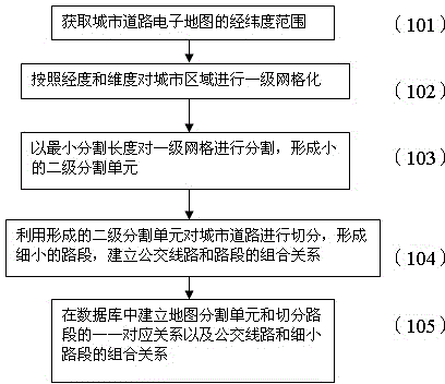
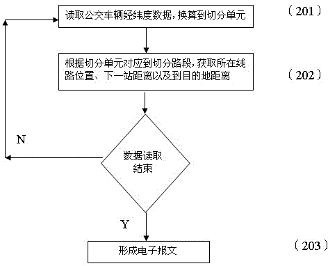
[0019] In order to realize the grid processing optimization method, firstly, the city needs to be gridded to the second level, and then the road is divided according to the grid and the corresponding relationship between the grid and the road section is established, and then each bus line is divided into basic units to establish The corresponding relationship between bus lines and cells is the initial preparation work, which only needs to be prepared once and saved to the database. Finally, according to the real-time bus position data, combined with the gridding starting point value and interval value, the first-level grid unit...


PUM


Abstract

A rectangular region based method for quickly positioning road bus points belong to is a method for quickly positioning urban buses to road sections. The method is characterized by comprising the steps of firstly conducting primary gridding on an urban region, then conducting secondary gridding in each grid unit, dividing urban roads into small road sections, and respectively establishing grid and road section one-to-one correspondence relation in the corresponding primary grid and secondary grid; Due to the fact that the bus routes are formed by combining the road sections, and after we conduct road gridding, all road sections included by each bus route are recorded according to route directions and saved in a database, then bus position data are positioned according to the grids the data belong to, finally each of the bus position data corresponds to the corresponding grid, the road sections the buses belong to are obtained, and the mileages from a previous station to a next station and a destination station are further obtained according to the precedence relation of the road sections included in the routes.

Description

technical field [0001] The invention belongs to the real-time data collection technology of public transport vehicles in the field of intelligent transportation, and proposes a method for quickly locating the roads to which vehicle points belong by adopting rectangular area screening. It is especially suitable for the real-time positioning of urban public transport and the acquisition of mileage data to the next station and the destination station. Background technique [0002] At present, in the bus route calculation, an important step that affects the calculation speed is how to determine the road or road section to which the vehicle point belongs. The existing methods mainly include: [0003] 1. Vector calculation based on electronic map: Generally, the search function of the electronic map system is called to find the road within the specified error range. This algorithm does not take into account the characteristics of many urban road sections and high road network de...

Claims


Application Information

Patent Timeline
Patent Type & Authority Applications(China)
IPC IPC(8): G08G1/123
CPCG08G1/123
Inventor 胡平
Owner HEFEI XINGFU INFORMATION TECH
Why Eureka
Try Eureka