Method and system for simulating reservoir digital outcrop surface

A digital outcrop and surface model technology, applied in the field of reservoir digital outcrop surface simulation, can solve problems such as difficulties and low efficiency of reservoir outcrop research, and achieve the effect of improving accuracy

Active Publication Date: 2015-02-04
PETROCHINA CO LTD
View PDF5 Cites 13 Cited by
  • Summary
  • Abstract
  • Description
  • Claims
  • Application Information

AI Technical Summary

Problems solved by technology

The traditional outcrop research method is on-site investigation. Therefore, in order to dissect reservoir outcrops, a large number of geologists usually carry geological tools such as geological hammers, measuring tapes, and magnifying glasses in the field for a long time. Difficult, and the research efficiency of reservoir outcrops is low

Method used


Image

  • Method and system for simulating reservoir digital outcrop surface
  • Method and system for simulating reservoir digital outcrop surface
  • Method and system for simulating reservoir digital outcrop surface

Examples


Embodiment 1

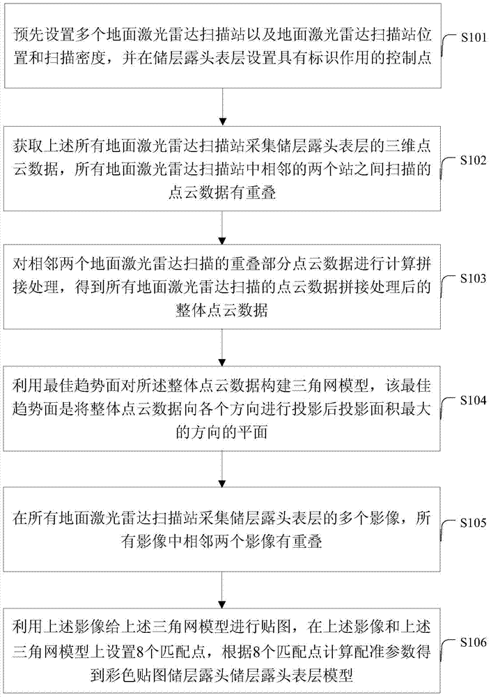
[0050] like figure 1 Shown is a flow chart of a method for reservoir digital outcrop surface simulation provided in Embodiment 1 of the present application. The method includes:

[0051] S101: Pre-setting a plurality of ground laser radar scanning stations 11 and the positions of the ground laser radar scanning stations and the scanning point spacing, and setting control points with marking functions on the surface of the reservoir outcrop;

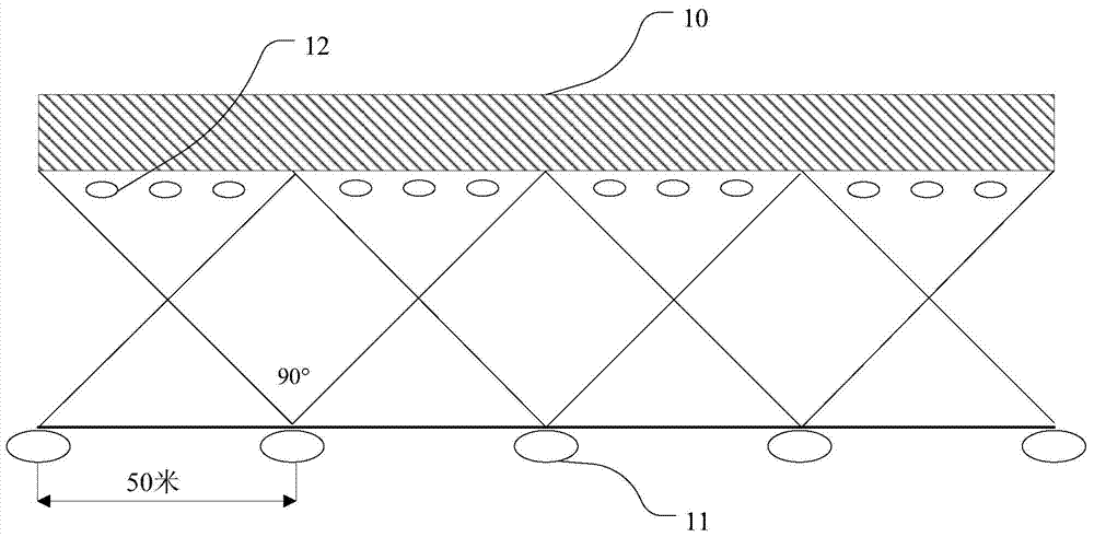
[0052] In practice, the number of ground lidar scanning stations 11 can be determined according to the scale of the reservoir outcrop, such as figure 2 Shown is a schematic diagram of an example of a reservoir outcrop data acquisition scheme, including a reservoir outcrop profile 10, a ground lidar scanning station 11 and a high-reflective sheet 12, and each scanning station 11 can be set at a distance from 10 meters to 100 meters from the target reservoir outcrop m, choose 50 meters in the present embodiment, the distance between two ad...

Embodiment 2

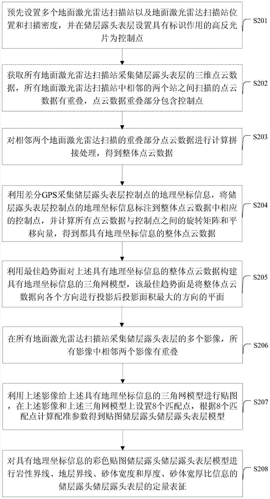
[0066] image 3 A flow chart of a method for reservoir digital outcrop surface simulation provided in Embodiment 2 of the present application, the method includes the following steps:

[0067] S201: Pre-setting multiple ground laser radar scanning stations 11 and the positions and scanning point spacing of ground laser radar scanning stations 11, and setting high reflective sheets 12 with marking function as control points on the surface of the reservoir outcrop.

[0068] In practice, the number of ground lidar scanning stations 11 can be determined according to the scale of the reservoir outcrop, such as figure 2 Shown is a schematic diagram of an example of a reservoir outcrop data acquisition scheme, including a reservoir outcrop profile 10, a ground lidar scanning station 11 and a high-reflective sheet 12, and each scanning station 11 can be set at a distance from 10 meters to 100 meters from the target reservoir outcrop m, choose 50 meters in the present embodiment, the...


PUM


Abstract

The embodiment of the invention provides a method and a system for simulating a reservoir digital outcrop surface. The method comprises the following steps: a plurality of ground laser radar scanning stations are pre-arranged to acquire three-dimensional point cloud data of a reservoir outcrop surface and a plurality of images of the reservoir outcrop surface, and the overlapping proportion of the point cloud data scanned between two adjacent stations among the ground laser radar scanning stations is controlled by a control point arranged on the reservoir outcrop surface and having an identification function; then, the overlapped point cloud data of the two adjacent ground laser radar scanning stations is calculated and spliced to obtain the overall point cloud data; a triangulated network model is constructed for the overall point cloud data by use of an optimal trend surface; and the triangulated network model is mapped with the images to obtain a mapped triangulated network model of the reservoir outcrop surface.

Description

technical field [0001] The invention relates to the technical field of reservoir geological simulation, in particular to a method and system for reservoir digital outcrop surface simulation. Background technique [0002] Reservoir outcrop is the true description of underground reservoir. The investigation and dissection of reservoir outcrop is an effective means to establish geological model of underground reservoir, which can be widely used in oil and gas exploration and oil and gas development technology. The traditional outcrop research method is on-site investigation. Therefore, in order to dissect reservoir outcrops, a large number of geologists usually carry geological tools such as geological hammers, measuring tapes, and magnifying glasses in the field for a long time. Difficult, and the research efficiency of reservoir outcrops is low. Contents of the invention [0003] The purpose of this application is to provide a method and system for reservoir digital outcro...

Claims


Application Information

Patent Timeline
Patent Type & Authority Applications(China)
IPC IPC(8): G06T17/05
CPCG06T15/005G06T17/05
Inventor 曾齐红谢兴叶勇刘松马志国张友焱胡艳张强于世勇申晋利邢学文
Owner PETROCHINA CO LTD
Why Eureka
Try Eureka