Method for performing geologic and topographic measurement by utilizing High One quad-rotor plane

A topographic measurement and four-rotor technology, applied in the direction of measuring devices, surveying and navigation, instruments, etc., can solve the problems of time-consuming and labor-intensive artificial geological topography measurement, difficult to complete geological topography measurement, time-consuming and energy-consuming problems, and achieve cost savings and Time, efficient and quick measurement work, and the effect of liberating labor force

Inactive Publication Date: 2015-02-18
芒市海华开发有限公司
View PDF7 Cites 5 Cited by
  • Summary
  • Abstract
  • Description
  • Claims
  • Application Information

AI Technical Summary

Problems solved by technology

[0002] At present, geological topography survey and finding points mainly rely on manual work, but there are many disadvantages in artificial geological topography survey, firstly, it is troublesome to set up the instrument; secondly, due to the places involved in geological survey, the topography and landform are generally relatively complicated, and the straight-line distance is often very long. In short places, it is necessary to go over mountains and ridges when measuring; therefore, it takes a lot of time and energy to find and measure m

Method used


Image

  • Method for performing geologic and topographic measurement by utilizing High One quad-rotor plane

Examples


Embodiment Construction

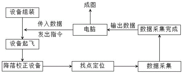
[0012] Assemble the RTK (Real - time kinematic) measuring instrument and GPS positioning and navigation system on the High One quadrotor aircraft. The assembly requirements: have the functions of flight, automatic navigation and positioning according to instructions, measurement and automatic storage) to form a controllable unmanned measurement equipment; Connect the measuring device to the computer; import the required data collection related information and instructions into the measuring device; after the import is completed, start the measuring device, wait for the measuring device to fly to the reference point and correct it according to the computer's instructions. After the calibration is completed, fly to the measuring point Landing for measurement, after measuring one point, continue to fly to the next measurement point, and so on, until all measurement points are measured; after the data collection is completed, land the High One quadrotor aircraft (return to the origi...


PUM


Abstract

The invention relates to a method for performing geologic and the topographic measurement by utilizing a High One quad-rotor plane. The method comprises the following steps: assembling RTK (Real-time kinematic) measurement instrument and a GPS onto the High One quad-rotor plane to form controllable unmanned measuring equipment; then introducing information and related command of data required for measurement into the equipment, sequentially performing the taking-off, landing calibration, data acquisition and the like of the measurement equipment, inputting the data into a computer after the acquisition of the data required is completed, drawing a geologic-topographic map by utilizing AutoCAD software through the data acquired by the measurement equipment, thus completing the measurement. According to the method, the equipment is simple and available, the operation is easy, the economical practicability are strong, and the time and cost can be saved, so that the method is a method which can complete the geologic-topographic measurement work for places where people cannot reach or higher danger exists.

Description

technical field [0001] The invention relates to the field of geological topography survey, in particular to a method for geological topography survey using a High One quadrotor aircraft. Background technique [0002] At present, geological topography survey and finding points mainly rely on manual work, but there are many disadvantages in artificial geological topography survey, firstly, it is troublesome to set up the instrument; secondly, due to the places involved in geological survey, the topography and landform are generally relatively complicated, and the straight-line distance is often very long. In short places, it is necessary to go over mountains and ridges when measuring; therefore, it takes a lot of time and energy to find and measure measuring points, and even needs to open a special road; some places that need to be measured are difficult for people to reach, or there are huge gaps. Therefore, artificial geological topography surveys are often time-consuming an...

Claims


Application Information

Patent Timeline
IPC IPC(8): G01C7/02
CPCG01C7/02
Inventor 陈水奇缪祥龙邵维龙许乌朋许春景
Owner 芒市海华开发有限公司
Why Eureka
Try Eureka