POI (point of interest) street view image displaying method and device

A point of interest and panoramic image technology, applied in the field of electronic maps, can solve problems such as low efficiency, high consumption of system resources, long calculation time for processing and displaying street view images, etc., to reduce system resources, improve processing efficiency, and optimize display effects Effect

Active Publication Date: 2015-02-25
ALIBABA (CHINA) CO LTD
View PDF3 Cites 29 Cited by
  • Summary
  • Abstract
  • Description
  • Claims
  • Application Information

AI Technical Summary

Problems solved by technology

[0006] In view of this, the embodiments of the present invention provide a POI street view image display method and device, which are used to solve the existing POI street view image display method that consumes a lot of system resources, takes a long time to process and display street view images, and The problem of inefficiency

Method used


Image

  • POI (point of interest) street view image displaying method and device
  • POI (point of interest) street view image displaying method and device
  • POI (point of interest) street view image displaying method and device

Examples


Embodiment 1

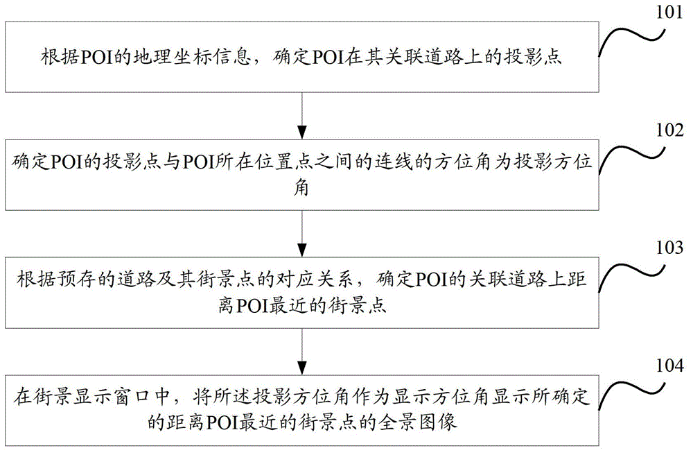
[0040] Figure 1c It shows the working flow chart of the POI street view image display method provided by the embodiment of the present invention, the method includes:

[0041] Step 101, according to the geographical coordinate information of the POI, determine the projection point of the POI on its associated road;

[0042] Specifically, before performing step 101, it is also necessary to determine the associated road of the POI, specifically including: in the case of saving the correspondence between the POI identifier and the associated road, in the pre-stored correspondence between the POI and its associated road, search for the The associated road of the POI;

[0043] In the case that the corresponding relationship between the POI identification and the associated road is not saved, according to the geographical coordinate information of the POI and the geographical coordinate information of the pre-stored road, it is determined that the road closest to the POI is the as...

Embodiment 2

[0069] Figure 6 It shows another work flow chart of the POI street view image display method provided by the embodiment of the present invention, the method includes:

[0070] Step 601, according to the geographical coordinate information of the POI and the geographical coordinate information of the pre-stored street point, determine the street point closest to the POI;

[0071] Specifically, this step can be implemented in one of the following two ways:

[0072] Method 1. According to the geographical coordinate information of POI and the geographical coordinate information of pre-stored street spots, determine the street spot closest to POI; preferably, the street spot closest to POI can be determined among the street spots within a predetermined range from POI. attractions to reduce computation;

[0073] Method 2: Determine the associated road of the POI according to the geographical coordinate information of the POI; determine the street point closest to the POI on the ...

Embodiment 3

[0084] Corresponding to Embodiment 1, based on the same inventive concept, this embodiment of the present invention also provides a POI street view image display device, such as Figure 7 As shown, the device includes:

[0085] The first determination module 71 is used to determine the projection point of the POI on its associated road according to the geographical coordinate information of the POI;

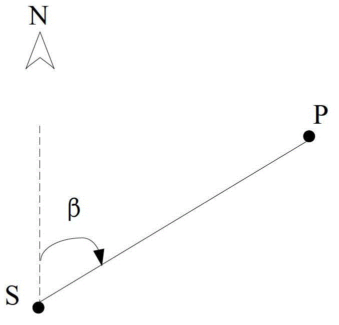
[0086] The second determination module 72 is connected to the first determination module 71, and is used to determine the azimuth angle of the line connecting the POI projection point determined by the first determination module 71 and the PO location point as the projection azimuth;

[0087] The third determination module 73 is used to determine the street point closest to the POI on the associated road of the POI according to the pre-stored correspondence between the road and its street point;

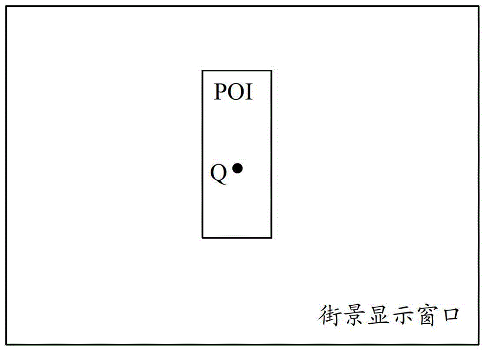
[0088] The display module 74 is connected to the second determination module 72 an...


PUM


Abstract

The invention discloses a POI (point of interest) street view image displaying method and device and aims to solve the problem that the existing POI street view image displaying methods consume excess system resources, take long calculation time to process and display street view images and are low in efficiency. According to the method and device, a projection point of a POI on a road related to the POI is determined, an azimuth of a line of the projection point of the POI and the POI is determined as a displaying azimuth or an azimuth of a line of the POI and a street view closest to the POI is determined as a displaying azimuth, and a panorama of the street view the closest to the POI is displayed at the displaying azimuth in a street view display window. During processing point cloud data of the POI is not required; system resources consumed in processing can be significantly reduced, calculation time for processing and displaying the street view image can be evidently shortened, and processing efficiency is improved.

Description

technical field [0001] The present invention relates to the field of electronic maps, in particular to a method and device for displaying street view images of points of interest. Background technique [0002] At present, when a user queries or browses an electronic map, he sometimes needs to view a street view image of a point of interest (POI, Point of Interest) in the map. A POI can be a building, a store, a mailbox or a bus stop, etc. In a geographic information system, the attribute parameters of a POI usually include: the name, category, geographic coordinate information of the POI, and the road sign of the road associated with the POI (For example, the sign of the road where the POI is located or the sign of the road closest to the POI). Street view images are panoramic images obtained by taking 360-degree live-action shots of special-purpose street view vehicles on a street at a certain distance (for example, 5 meters) at points of interest (also known as street poi...

Claims


Application Information

Patent Timeline
Patent Type & Authority Applications(China)
IPC IPC(8): G06F17/30
CPCG06F16/29G06F16/9537
Inventor 杨自华
Owner ALIBABA (CHINA) CO LTD
Why Eureka
Try Eureka