SINS/LBL (strapdown inertial navigation systems/long base line) tight combination based AUV (autonomous underwater vehicle) underwater navigation positioning method

A technology of navigation positioning and tight combination, which is applied to the tracking and positioning of underwater autonomous vehicles AUV, and the field of AUV underwater navigation and positioning based on SINS/LBL tight combination

Active Publication Date: 2015-03-25
SOUTHEAST UNIV
View PDF2 Cites 40 Cited by
  • Summary
  • Abstract
  • Description
  • Claims
  • Application Information

AI Technical Summary

Problems solved by technology

[0006] Aiming at the problem of the existing AUV underwater navigation accuracy, the present invention

Method used


Image

  • SINS/LBL (strapdown inertial navigation systems/long base line) tight combination based AUV (autonomous underwater vehicle) underwater navigation positioning method
  • SINS/LBL (strapdown inertial navigation systems/long base line) tight combination based AUV (autonomous underwater vehicle) underwater navigation positioning method
  • SINS/LBL (strapdown inertial navigation systems/long base line) tight combination based AUV (autonomous underwater vehicle) underwater navigation positioning method

Examples


Embodiment Construction

[0088] The present invention will be further explained below in conjunction with the drawings.

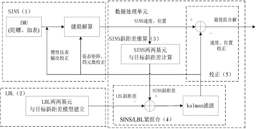
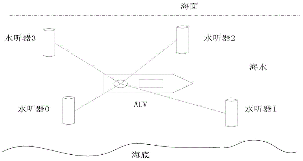
[0089] Such as figure 1 As shown, the present invention is composed of a strapdown inertial navigation system SINS (1) installed on the AUV, a long baseline underwater acoustic positioning system LBL (2) deployed on the seabed, and a data processing unit. The data processing unit includes SINS pairwise primitives and AUV slant distance difference calculation module (3), SINS / LBL tight combination module (4) and correction module (5). The AUV underwater autonomous navigation is completed by using the tight combination of SINS and LBL. The specific implementation steps are as follows:

[0090] (1) For the output data of the inertial measurement unit (IMU), the AUV position information is obtained through strap-down calculation, using the earth coordinate P SINS (L S ,λ S ,h S ) Means, and P SINS (L S ,λ S ,h S ) Is converted to P SINS (x S ,y S ,z S ) Means.

[0091] The SINS(1) system in...


PUM


Abstract

The invention provides an SINS/LBL (strapdown inertial navigation systems/long base line) tight combination based AUV (autonomous underwater vehicle) underwater navigation positioning method. The SINS/LBL tight combination based AUV underwater navigation positioning method is characterized by comprising three major parts, namely an SINS mounted on an AUV, an LBL underwater sound positioning system laid on the seabed, and a data processing unit. The method comprises the following specific steps: firstly performing a strapdown algorithm on IMU (inertial measurement unit) data to obtain AUV position information, and representing the position information by using earth rectangular coordinates; secondly reckoning an SINS slant-range difference according to the AUV position information provided by the SINS and hydrophone array position coordinates; and thirdly establishing an LBL slant-range difference model according to LBL positioning characteristics, and correcting SINS navigation positioning information according to filter estimation compensation by taking the difference value between the SINS slant-distance difference and the LBL slant-distance difference as an observed quantity of a kalman filter. According to the SINS/LBL tight combination based AUV underwater navigation positioning method, the use of GPS and other radio positioning systems is avoided at the same, and the AUV underwater operation efficiency is improved.

Description

Technical field [0001] The invention mainly relates to the technical field of AUV underwater navigation, in particular to an AUV underwater navigation positioning method based on a tight combination of SINS / LBL, and is particularly suitable for the tracking and positioning of an underwater autonomous vehicle AUV. Background technique [0002] AUV (Autonomous Underwater Vehicle, autonomous underwater vehicle) is an underwater tool that can complete underwater detection, attack, transportation, salvage and other functions. Because of its wide range of activities, small size, light weight, and concealment Advanced features have now become an important direction of military marine technology research at home and abroad. [0003] AUV underwater high-precision autonomous navigation and positioning and tracking technology is the prerequisite and key to completing its underwater operations. Among the existing positioning technologies, SINS (Strapdown Inertial Navigation Systems) has stron...

Claims


Application Information

Patent Timeline
IPC IPC(8): G01C21/18G06F19/00
CPCG01C21/165
Inventor 张涛石宏飞徐晓苏陈立平
Owner SOUTHEAST UNIV
Why Eureka
Try Eureka