Channel sandstone reservoir identification method

An identification method and channel sand body technology, applied in the identification field of channel sandstone reservoirs, can solve problems such as difficulties in sand body identification and description, insufficient research on response characteristics, and large burial depths

Active Publication Date: 2015-04-08
CHINA PETROLEUM & CHEM CORP
View PDF4 Cites 41 Cited by
  • Summary
  • Abstract
  • Description
  • Claims
  • Application Information

AI Technical Summary

Problems solved by technology

[0005] 1) Tahe Oilfield has a large burial depth (>4200m) of the A4 member of the Triassic, thin sand body thickness (5-10m), low seismic resolution (λ/4=25m), and the target sandstone thickness is much smaller than the seismic resolution , it is difficult to identify and describe sand bodies;
[0006] 2) The lithological configuration of the A4 member is diverse. The response characteristics of

Method used


Image

  • Channel sandstone reservoir identification method

Examples


Embodiment Construction

[0039] In order to fully understand the purpose, features and effects of the present invention, the present invention will be described in detail through the following specific embodiments, but the present invention is not limited thereto.

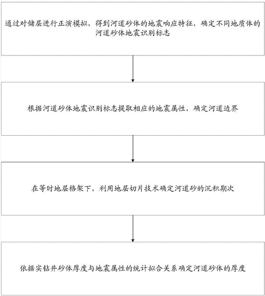
[0040] The invention identifies and describes the channel sandstone oil reservoir by determining the seismic sign of the channel sandstone oil reservoir, the channel boundary, the sedimentary stage and the thickness of the sand body.

[0041] figure 1 A flow chart showing the method for identifying channel sandstone reservoirs provided by the present invention, such as figure 1 As shown, the method includes the following parts:

[0042] 1) Through the forward modeling of the reservoir, the seismic response characteristics of channel sand bodies are obtained, and the seismic identification marks of channel sand bodies of different geological bodies are determined; the seismic response characteristics include seismic reflection characterist...


PUM

PropertyMeasurementUnit
Thicknessaaaaaaaaaa
Thicknessaaaaaaaaaa
Thicknessaaaaaaaaaa

Abstract

The invention discloses a channel sandstone reservoir identification method. The method includes: acquiring seismic response features of channel sand by performing forward modelling on reservoirs, and determining channel-sand seismic identification marks of different geologic bodies; extracting corresponding seismic attributes according to the channel sand seismic identification marks, and determining a channel boundary; under an isochronous stratigraphic frame, determining sedimentary periods of the channel sand by the aid of the stratal slice technique; determining the thickness of the channel sand according to the statistical fitting relation of the real well-drilling sand thickness and the seismic attributes. According to the method, the channel sand identification and description technology is created by going deep into seismic attribute extraction and analysis, utilizing the reservoir of the fixed well, reservoir calibration results and statistical analysis of well drilling and combining forward model analysis results. Channel sandstone reservoirs of ultra-deep layers, thin sand layers and narrow channels can be identified and described accurately, and influence of seismic resolution is less.

Description

technical field [0001] The invention relates to the fields of geology and petroleum development, in particular to a method for identifying channel sandstone reservoirs. Background technique [0002] The structure of Tahe Oilfield is located in the south of the Akekule uplift in the Shaya uplift in the northern Tarim Basin. Oil and Gas Field. [0003] With the increasing difficulty of peripheral exploration and block restrictions, in order to further expand oil and gas exploration results, according to the characteristics of low-amplitude structural anticlines and faulted anticline traps of clastic rocks in Tahe Oilfield, high-resolution seismic data are used to target Based on processing and based on fine reservoir calibration, comprehensive clastic rock structures such as fine coherent fault interpretation, seismic attribute extraction and optimization, joint seismic logging inversion, 3D visual geological body detection, fine velocity research, and pattern recognition oil...

Claims


Application Information

Patent Timeline
IPC IPC(8): G01V1/28G01V1/30
Inventor 鲁新便李宗杰李雪张志强盛海波石玉先伟葛善良李喜莲顾伟欣郭瑞黄鹏
Owner CHINA PETROLEUM & CHEM CORP
Why Eureka
Try Eureka