Evaluation method for efficiency of satellite data receiving system

A satellite data and receiving system technology, applied in the direction of electrical digital data processing, special data processing applications, instruments, etc., can solve the problems of lack of unified evaluation indicators, etc., and achieve the effect of easy decomposition and combination, and clear structure

Active Publication Date: 2015-05-06
INST OF REMOTE SENSING & DIGITAL EARTH CHINESE ACADEMY OF SCI +1
View PDF0 Cites 12 Cited by
  • Summary
  • Abstract
  • Description
  • Claims
  • Application Information

AI Technical Summary

Problems solved by technology

The performance index of the satellite data receiving system covers many aspects. At present, the research on the performance evaluation index of the satellite data receiving system focuses on the analysis and evaluation of the receiving ability index, and lacks a unified evaluation index, especially for the evaluation of the satellite data receiving task planning algorithm. A unified evaluation method has not yet been formed. Various task planning model algorithms are involved in receiving task planning, and each algorithm has a specific scope of application and technical characteristics. The purpose of expanding the algorithm is to be able to conduct a systematic evaluation of the performance and scope of the algorithm, so as to determine how to choose the algorithm in the planning process

Method used


Image

  • Evaluation method for efficiency of satellite data receiving system
  • Evaluation method for efficiency of satellite data receiving system
  • Evaluation method for efficiency of satellite data receiving system

Examples


Embodiment Construction

[0048] In order to make the object, technical solution and advantages of the present invention clearer, the present invention will be further described in detail below in conjunction with specific embodiments and with reference to the accompanying drawings.

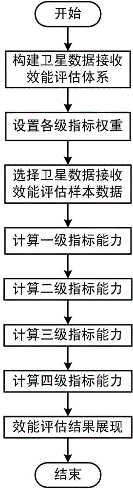
[0049] The invention discloses an efficiency evaluation method of a satellite data receiving system, such as figure 1 shown, including the following steps:

[0050] Step 1: Construct the satellite data receiving system performance evaluation system;

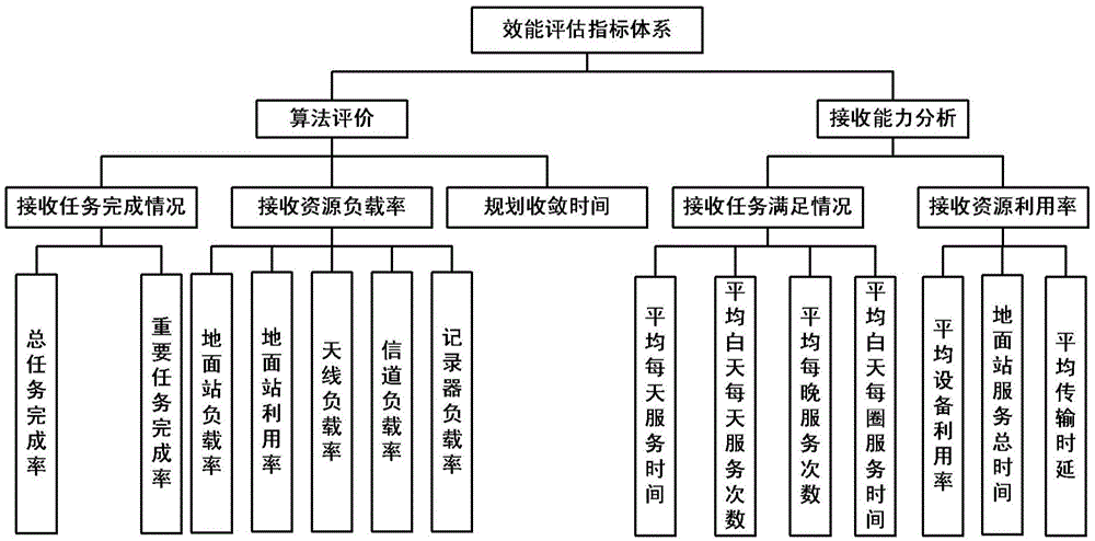
[0051] The constructed performance evaluation index system includes four levels of indexes, such as figure 2As shown, the lowest layer is the first-level indicators of the satellite data receiving system. The first-level indicators are calculated from the corresponding evaluation sample data generated during the satellite data receiving process, including the total task completion rate, important task completion rate, ground station load rate, Ground station utilization, ...


PUM


Abstract

The invention discloses an evaluation method for efficiency of a satellite data receiving system. The evaluation method comprises the following steps: building a satellite data receiving efficiency evaluation index system; calculating primary indexes of the satellite data receiving system; calculating secondary indexes of the satellite data receiving system; calculating tertiary indexes of the satellite data receiving system; calculating integral indexes of the satellite data receiving system; demonstrating efficiency evaluation result. According to the invention, the efficiency evaluation indexes system covering comprehensively and systematically is provided directed towards the problems that conventional efficiency evaluation methods for satellite data receiving systems are difficult to conduct systematic, meticulous and comprehensive evaluation; the indexes system comprises four stages of indexes, and covers multiple aspects of satellite receiving responsibility planning algorithm evaluation, receiving capability analysis, and the like; the method has the characteristics that the method is clear in structure, and easy to disintegrate and combine, and realizes multi-scale efficiency evaluation of the satellite data receiving system.

Description

technical field [0001] The invention relates to the field of aerospace and ground applications, in particular to an efficiency evaluation method for a satellite data receiving system. Background technique [0002] With the continuous development of the satellite data ground receiving system, there are more and more space information system facilities such as various satellites. How to carry out the performance evaluation of the satellite data ground receiving system to guide the layout and development of satellite-ground resources is the key to satellite data receiving. An important topic in system design and development. The performance index of the satellite data receiving system covers many aspects. At present, the research on the performance evaluation index of the satellite data receiving system focuses on the analysis and evaluation of the receiving ability index, and lacks a unified evaluation index, especially for the evaluation of the satellite data receiving task p...

Claims


Application Information

Patent Timeline
Patent Type & Authority Applications(China)
IPC IPC(8): G06F19/00
Inventor 林晓勇黄鹏章文毅冯阳孔庆玲陈金勇尚希杰崔庆丰马广彬过西荣冯柯张超周彤贾士达裴艳峰
Owner INST OF REMOTE SENSING & DIGITAL EARTH CHINESE ACADEMY OF SCI
Why Eureka
Try Eureka