
Aerial photography system and method for specified path of quadrotor aircraft based on smart phone

A technology for quadrotor aircraft and smart phones, which can be used in aircraft parts, transportation and packaging, telephone communication, etc. It can solve the problems of high load requirements for quadrotors, single functions, and restrictions on the popularization and application of quadrotors.

Active Publication Date: 2016-08-24
WUHAN UNIV OF SCI & TECH
View PDF4 Cites 0 Cited by
  • Summary
  • Abstract
  • Description
  • Claims
  • Application Information

AI Technical Summary

Problems solved by technology

[0003] Existing quadrotors are dedicated flight control modules designed separately, mainly based on remote-controlled model quadrotors, with single functions and few sensors, and most of them do not have aerial photography functions; the external aerial photography equipment is not only expensive, but also heavy Large, there are high requirements for the load of the quadrotor; at the same time, the remote control distance of the 2.4GHz wireless remote control technology is limited, and it is not suitable for large-scale flight over 1km
All of these restrict the popularization and application of quadrotors.

Method used


Image

  • Aerial photography system and method for specified path of quadrotor aircraft based on smart phone
  • Aerial photography system and method for specified path of quadrotor aircraft based on smart phone
  • Aerial photography system and method for specified path of quadrotor aircraft based on smart phone

Examples


Embodiment Construction

[0039] In order to further illustrate the technical solution of the present invention, the present invention is described in detail with reference to the accompanying drawings.

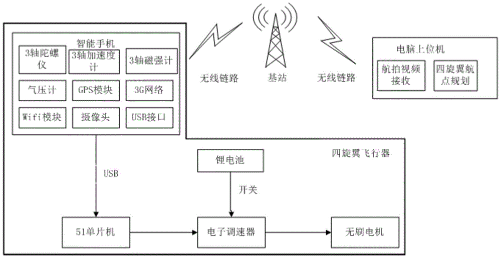
[0040] figure 1 Shown is a structural block diagram of the smart phone-based four-rotor specified path aerial photography system of the present invention. The four-rotor specified path aerial photography system based on smart phone includes smart phone (with high-speed multi-core or single-core CPU processor), four-rotor and computer host computer; the smart phone is equipped with GPS, barometer, gyroscope, accelerometer , magnetometer, camera, wireless network, and wireless communication with the computer host computer; the frame of the quadrotor is provided with a smart phone access module, a drive module, a power module, and an energy module; the power module includes four The motor and propeller of the rotor, each rotor is driven by an independent rotor drive motor ( figure 1 is a brushless moto...


PUM


Abstract

The invention relates to a quadrotor aircraft specified path aerial photography system and method based on an intelligent mobile phone. The intelligent mobile phone is fixedly arranged on a machine frame of a quadrotor aircraft; through a ground computer host, a plurality of airline destinations with representativeness on a path requiring aerial photography are selected, and are sent to the intelligent mobile phone according to the distance sequence of the airline destinations from a starting point; a BackSepping path tracking algorithm is adopted for smoothly tracking the airline destinations output by the computer host; a self-provided high-definition camera of the intelligent mobile phone is utilized for collecting image information on the specified path, and aerial photography videos are downloaded to the computer host in real time through a 3G (3rd generation telecommunication) wireless network, and the quadrotor aerial photography according to the specified path is realized.

Description

technical field [0001] The patent of the present invention relates to the field of control of unmanned aerial vehicles, in particular to a quadrotor unmanned helicopter controlled by a mobile phone. Background technique [0002] With the rapid development of science and technology, people's research on computers is also deepening day by day; whether it is its size, weight or computing power, great progress has been made. With the reduction of the price of smartphones, smartphones equipped with rich and high-precision sensors have become an important part of people's work, life, and entertainment; secondly, with the maturity of quadrotor control technology, quadrotors have been applied in society Many industries, and gradually into the lives of ordinary people. [0003] Existing quadrotors are dedicated flight control modules designed separately, mainly based on remote-controlled model quadrotors, with single functions and few sensors, and most of them do not have aerial pho...

Claims


Application Information

Patent Timeline
Patent Type & Authority Patents(China)
IPC IPC(8): B64D47/00H04M1/725
Inventor 吴怀宇滕雄钟锐陈洋余辉陈鹏震
Owner WUHAN UNIV OF SCI & TECH
Learn More