Feature extraction method for high spatial resolution remote sensing big data

A high spatial resolution, feature extraction technology, applied in instruments, character and pattern recognition, computer parts and other directions, can solve problems such as the inability to accurately express the nature of ground objects, achieve rich texture and shape information, high spatial resolution, The effect of reliable conversions

Inactive Publication Date: 2015-06-10
HARBIN INST OF TECH
View PDF5 Cites 16 Cited by
  • Summary
  • Abstract
  • Description
  • Claims
  • Application Information

AI Technical Summary

Problems solved by technology

[0008] The purpose of the present invention is to solve the problem that the existing feature extraction and acquisition of high spatial resolution remote sensing images are low-level features, which cannot accurately express the nature of ground objects, and provide a feature extraction method for high spatial resolution remote sensing big data

Method used


Image

  • Feature extraction method for high spatial resolution remote sensing big data

Examples


specific Embodiment approach 1

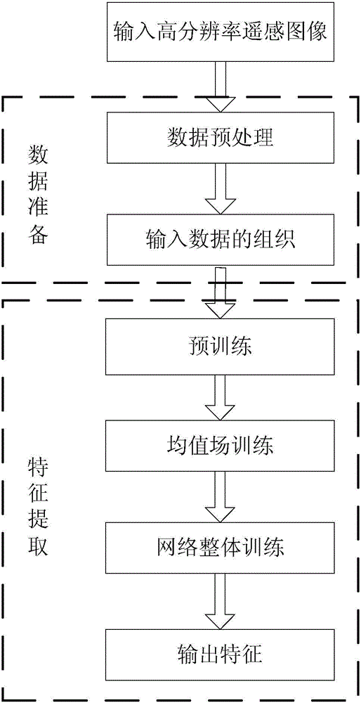
[0020] Specific implementation mode one: the following combination figure 1 Describe this embodiment, the feature extraction method facing high spatial resolution remote sensing big data described in this embodiment, it comprises the following steps:

[0021] Step 1: collect remote sensing images, and preprocess the remote sensing images to obtain input data;

[0022] Step 2: Divide the input data into continuous and non-overlapping sub-image data of 31×31 or 51×51 pixels;

[0023] Step 3: Input the subgraph data to the corresponding nodes in the input layer of the convolutional deep Boltzmann machine in sequence, and the subgraph data are modified and convolved by the hidden sublayer of the low-level semantic layer of the convolutional deep Boltzmann machine After the convolution mapping after the kernel, the extraction operation is performed through the extraction sublayer of the low-level semantic layer to obtain the low-level semantic features of the sub-graph data;

[0...

specific Embodiment approach 2

[0034] Specific implementation mode two: the following combination figure 1 This embodiment is described. This embodiment further describes Embodiment 1. The preprocessing of remote sensing images includes: sequentially performing geometric fine correction, image registration, image mosaic and cropping, and atmospheric correction on remote sensing images.


PUM


Abstract

The invention relates to a feature extraction method for high spatial resolution remote sensing big data and belongs to the technical field of remote sensing image feature extraction. The feature extraction method for the high spatial resolution remote sensing big data aims to solve the problem that the obtained features of an existing feature extraction for high spatial resolution remote sensing images are low-level features so that the essential can not be expressed accurately. The feature extraction method for the high spatial resolution remote sensing big data comprises the steps of first collecting remote sensing images, pre-processing the remote sensing images and obtaining input data; parting the input data to continuous and non-overlapping 31*31 or 51*51 pixel sub-image data; inputting the sub-image data successively to corresponding nodes of an input layer of a convolution depth Boltzman machine and obtaining low-level semantic features of the sub-image data; taking the low-level semantic features of the sub-image data as a high-level semantic layer of the convolution depth Boltzman machine, and obtaining essential features of the sub-image data; furthermore, obtaining standard 51x contextual information; finally outputting feature extraction results of the input data by a Logistic classifier. The feature extraction method for the high spatial resolution remote sensing big data is used for feature extraction of remote sensing big data.

Description

technical field [0001] The invention relates to a feature extraction method for high spatial resolution remote sensing big data, and belongs to the technical field of remote sensing image feature extraction. Background technique [0002] In the past ten years, high spatial resolution remote sensing images have been widely used in agriculture, forestry, ocean and environmental monitoring and other fields, and have huge economic value and social benefits. However, due to the large volume of high-spatial-resolution remote sensing images, various data types, rich information, and complex interpretation and analysis processes, it has been difficult to accurately and efficiently automatically perform high-spatial-resolution remote sensing images. classification of features. How to classify ground objects on high spatial resolution remote sensing big data has become one of the technical difficulties and bottlenecks affecting its large-scale application. [0003] Compared with med...

Claims


Application Information

Patent Timeline
Patent Type & Authority Applications(China)
IPC IPC(8): G06K9/00G06K9/46
Inventor 陈曦陈雨时张晔
Owner HARBIN INST OF TECH
Why Eureka
Try Eureka