Visual positioning method based on vehicle-mounted panorama image and streetscape matching

A map matching and visual positioning technology, applied in the field of visual positioning, can solve the problems of difficult to reach marks, high cost, etc., and achieve the effect of easy popularization, strong realism, and improved sensitivity

Active Publication Date: 2015-06-24
BEIJING RES INST OF SPATIAL MECHANICAL & ELECTRICAL TECH
View PDF3 Cites 28 Cited by
  • Summary
  • Abstract
  • Description
  • Claims
  • Application Information

AI Technical Summary

Problems solved by technology

In order to ensure positioning in a larger area, geo-marking and 3D modeling must be performed on the entire area, which is expensive, and due to traffic and other reasons, many places are difficult to reach and mark

Method used


Image

  • Visual positioning method based on vehicle-mounted panorama image and streetscape matching
  • Visual positioning method based on vehicle-mounted panorama image and streetscape matching

Examples


Embodiment Construction

[0050] Specific embodiments of the present invention will be further described in detail below in conjunction with the accompanying drawings.

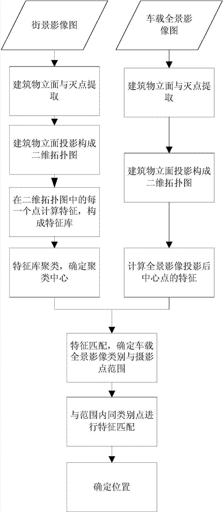
[0051] Such as figure 1 Shown is the flow chart of the present invention, from figure 1 It can be seen that a visual positioning method based on the matching of vehicle-mounted panoramic images and street view maps proposed by the present invention, the specific steps are as follows:

[0052] (1) Obtain a street view image, the street view image includes a panoramic projected street view image and a central projection image forming the street view image; the street view image is obtained through a panoramic network map.

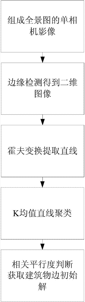
[0053] (2) Utilize the center projection image that constitutes the street view image in step (1), extract the building facade and the facade feature line in the street view image, and the facade feature line is perpendicular or parallel to the ground;

[0054] First, define the characteristics and definition of bui...


PUM


Abstract

The invention discloses a visual positioning method based on vehicle-mounted panorama images and streetscape matching. The visual positioning method comprises the following steps: firstly, acquiring streetscape images, extracting building facades and facade characteristic lines of the streetscape images, and extracting view shading characteristics so as to form view shading characteristic databases; clustering the view shading characteristics so as to obtain clustering result; secondly, acquiring view shading characteristics of the vehicle-mounted panorama images, confirming a vehicle-mounted panorama image taking point range and view shading characteristics within the range, and confirming clustering types corresponding to the view shading characteristics; and finally confirming type affiliation and final matching result of the view shading characteristics of the vehicle-mounted panorama images, and furthermore confirming the position of a vehicle. By adopting the visual positioning method, the difficulties that a GPS is poor in signal stability and applicability in urban areas and a conventional view positioning method is large in calculation amount and is not practical when depending on three-dimensional landform modeling can be avoided, vehicle-mounted panorama cameras which are popularized gradually and conventional streetscape maps with a great amount of data are adopted for positioning, and good landform applicability and positioning precision can be achieved.

Description

technical field [0001] The invention relates to a visual positioning method, in particular to a visual positioning method based on the matching of a vehicle-mounted panoramic image and a street view map. The optical image acquired by a vehicle-mounted panoramic remote sensing platform sensor is used to perform positioning when a GPS signal is missing in an urban area, which belongs to optical remote sensing image processing. technology field. Background technique [0002] Accurately measuring vehicle location information in urban areas is an important and challenging problem. Using GPS system positioning is the most common positioning method. Commercially operated GPS signals provide positioning information with an accuracy of 10 meters, and when ionospheric errors are accurately corrected, the positioning accuracy can be improved to the centimeter level. However, GPS signals often appear in urban areas due to insufficient number of receiving satellites due to high-rise bu...

Claims


Application Information

Patent Timeline
Patent Type & Authority Applications(China)
IPC IPC(8): G01C11/04
CPCG01C11/04G01C21/26
Inventor 尚志鸣林招荣文高进姚娜钟灿张春晓王洪民张倩曹桂丽
Owner BEIJING RES INST OF SPATIAL MECHANICAL & ELECTRICAL TECH
Why Eureka
Try Eureka