
Height positioning method for calibrating barometric leveling result in real time by use of satellite positioning information

A technology for satellite positioning and positioning results, applied in the field of navigation and positioning, it can solve the problems of drift, inconsistent measurement results, and drift of barometric altimetry over time, and achieve the effect of continuous elevation positioning.

Active Publication Date: 2015-07-01
ACAD OF OPTO ELECTRONICS CHINESE ACAD OF SCI
View PDF4 Cites 14 Cited by
  • Summary
  • Abstract
  • Description
  • Claims
  • Application Information

AI Technical Summary

Problems solved by technology

[0004] However, there are still some problems in the positioning of barometric altimetry: barometric altimetry has the characteristics of relatively high accuracy and short-term stability, but when working for a long time, it will be affected by the environment (wind speed, temperature, humidity, etc.) Issues with drift over time, with inconsistent measurements for days in a row
[0005] Based on the above technical background and application background, an elevation positioning method using satellite positioning information to calibrate the barometric altimetry results in real time is proposed, which solves the problem of barometric altimetry drifting with time, and can achieve stable and high-precision indoor and outdoor elevation positioning

Method used


Image

  • Height positioning method for calibrating barometric leveling result in real time by use of satellite positioning information
  • Height positioning method for calibrating barometric leveling result in real time by use of satellite positioning information
  • Height positioning method for calibrating barometric leveling result in real time by use of satellite positioning information

Examples


Embodiment Construction

[0018] The present invention will be described in detail below with reference to the accompanying drawings and examples.

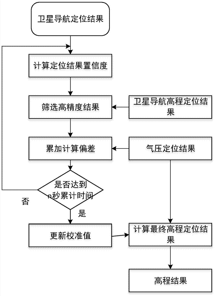
[0019] The altitude positioning method of the present invention utilizes satellite positioning information to calibrate the barometric altimetry results in real time, such as figure 1 As shown, it includes the following steps: Step 1. Using satellite positioning information, obtain the satellite positioning result of the moving target in real time, that is, the coordinate values ​​of the point to be measured on the x, y, and z axes of the geodetic coordinate system, and then obtain the described Confidence D of the three coordinate values x 、D y and D z ,Specifically:

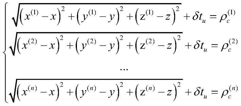
[0020] Confidence calculation involves the principle of GPS positioning and adopts the method of least squares. Assume that the pseudo-range observation is L and its precision is σ. GPS positioning equations:

[0021] ( ...


PUM


Abstract

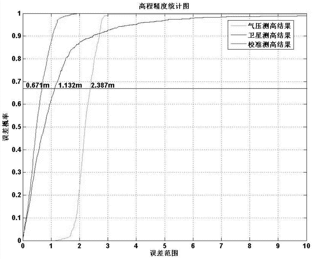
The invention discloses a height positioning method for calibrating the barometric leveling result in real time by use of satellite positioning information. The characteristics that the barometric leveling stability is good within a short period, the relative height accuracy is high and the satellite positioning precision is high in a part of discrete observation points are combined, the barometric leveling result is calibrated in real time by use of the satellite positioning information; and a conditional formula for screening the satellite positioning result is acquired through experimental and theoretical calculation, the positioning result with low precision is removed, high-precision result is kept and is compared with the barometric leveling result, high-precision and continuous height positioning can be realized, the positioning precision is superior to the satellite positioning height precision and the barometric leveling precision and can reach 1m, and the probability of achieving the precision is 66.7% (1sigma).

Description

technical field [0001] The invention relates to the key technology of navigation and positioning, and proposes an elevation positioning method that utilizes satellite positioning information to calibrate barometric altimetry results in real time, and realizes indoor and outdoor stable, high-precision elevation positioning. Background technique [0002] With the development of satellite navigation technology, the application range of navigation receivers has become wider and wider, and the demand for navigation and positioning in complex environments such as high-rise buildings in cities, under trees, and in canyons is increasing. However, the navigation receiver is greatly affected by the environment. When the user is in these complex environments, the satellite navigation signal will be blocked or interfered, which will lead to discontinuous positioning results of the terminal and lower positioning accuracy, especially in the elevation positioning oscillation. In addition, ...

Claims


Application Information

Patent Timeline
IPC IPC(8): G01C5/06G01C25/00
CPCG01C5/06G01C25/00
Inventor 来奇峰魏东岩公续平张晓光陈夏兰李祥红李雯袁洪徐颖
Owner ACAD OF OPTO ELECTRONICS CHINESE ACAD OF SCI
Learn More