Flood submergence duration simulation system and method based on remote sensing

A simulation system and simulation method technology, applied in climate change adaptation, data processing application, prediction, etc., can solve problems such as large amounts of data

Inactive Publication Date: 2015-07-08
CHINA INST OF WATER RESOURCES & HYDROPOWER RES +1
View PDF3 Cites 3 Cited by
  • Summary
  • Abstract
  • Description
  • Claims
  • Application Information

AI Technical Summary

Problems solved by technology

It still uses the traditional calculation method and requires a large amount of data as input

Method used


Image

  • Flood submergence duration simulation system and method based on remote sensing
  • Flood submergence duration simulation system and method based on remote sensing
  • Flood submergence duration simulation system and method based on remote sensing

Examples


Embodiment 1

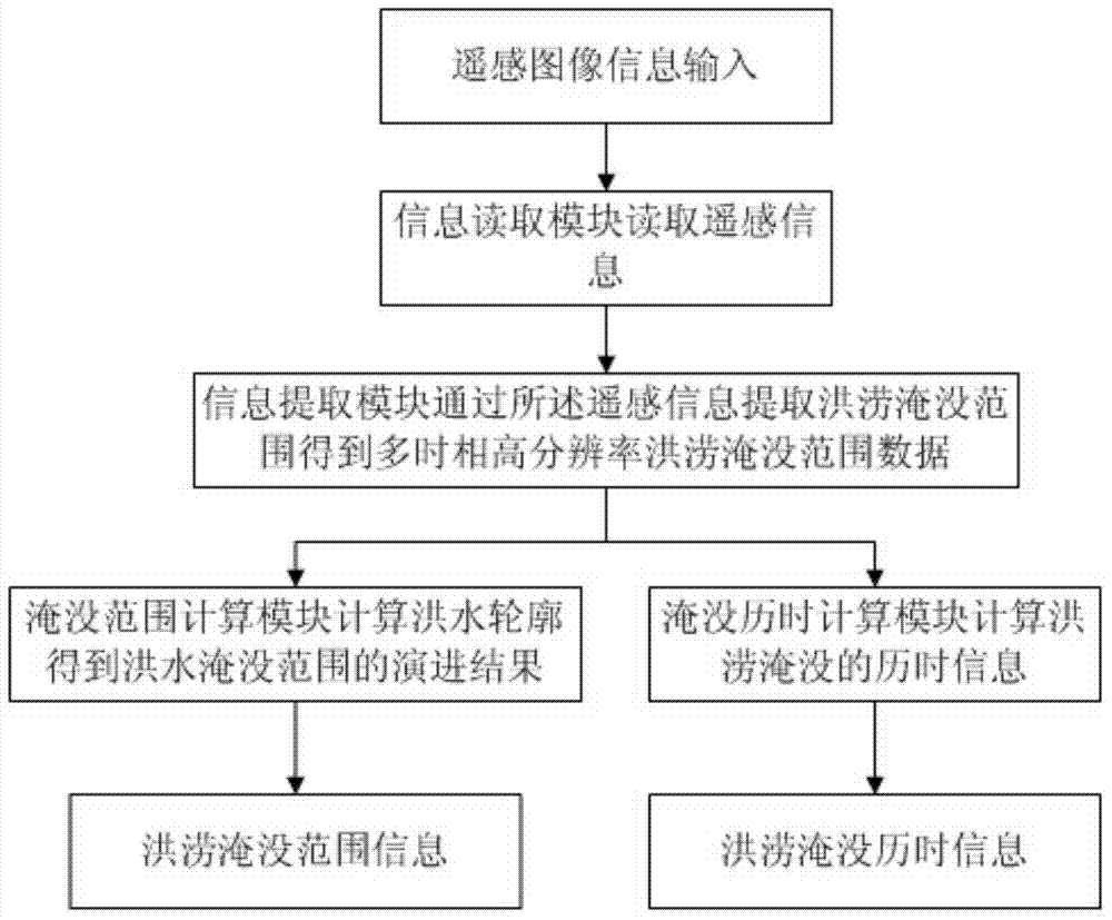
[0045] Such as Figure 1 As shown, it is a flow chart of a flood submersion duration simulation method in a preferred embodiment of the present invention. The diachronic simulation method includes the following steps:

[0046] The information reading module reads the remote sensing information;

[0047] The information extraction module extracts the flood submerged range from the remote sensing information to obtain multi-temporal high-time resolution flood submerged range data;

[0048] The submerged range calculation module calculates the flood profile to obtain the evolution result of the flood submerged range;

[0049] The submerged duration calculation module calculates the duration information of flood submersion;

[0050] The output module outputs thematic maps.

[0051] Wherein, the parameter information of the multi-temporal high-time resolution flood submersion range data includes: a time parameter and a water level parameter. The calculation modes of the submer...

Embodiment 2

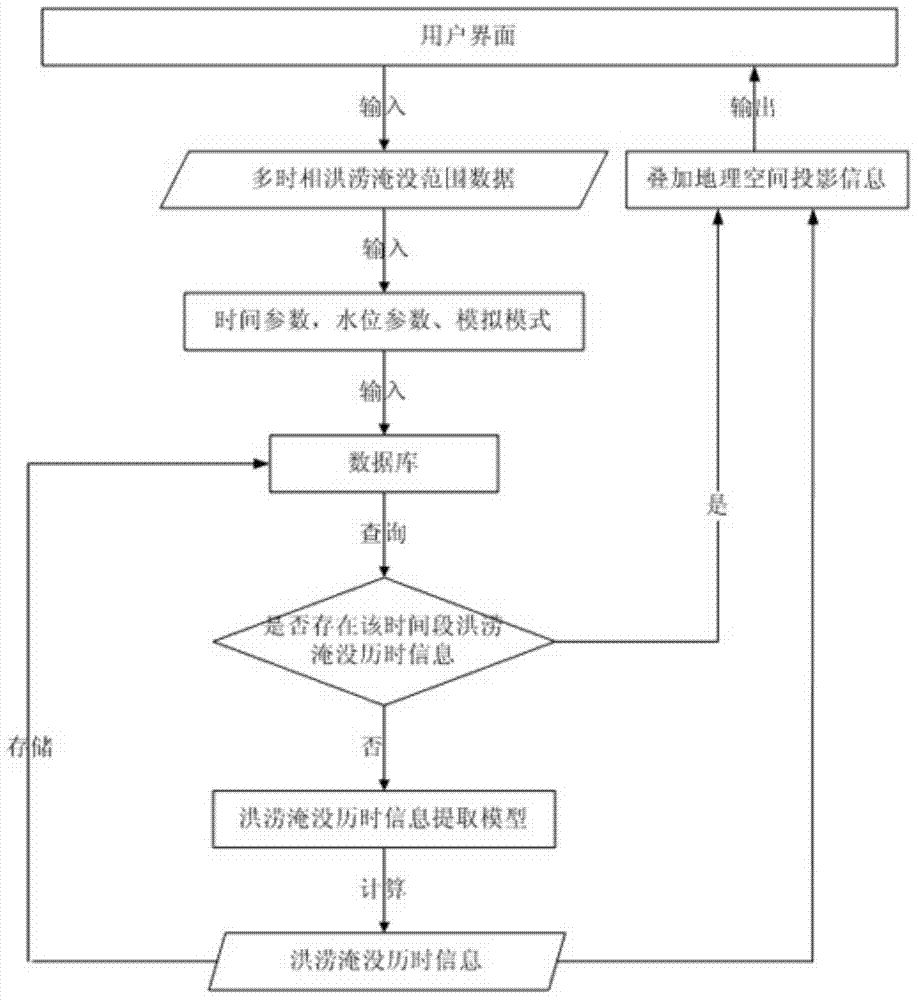
[0054] Such as figure 2 As shown, it is a diagram of the execution steps of the flood submersion duration simulation system according to a preferred embodiment of the present invention. First, the user needs to determine the number of time phases for inputting the high time resolution flood submersion range data, and input the data time phase by time parameters, water level parameters, and simulation modes; secondly, query the flood inundation range database to confirm whether the calculated flood inundation duration information in the required time period exists in the database. If it exists, it will be directly called out to display and output after superimposing the geospatial projection information; if not, the model will calculate the flood submersion duration information in this time period according to the specified simulation mode, and store it in the database, and superimpose the geospatial projection information output( Figure 7 ); at the same time, the user can c...

Embodiment 3

[0080] In this embodiment, discussion is made in conjunction with the actual use process of the system.

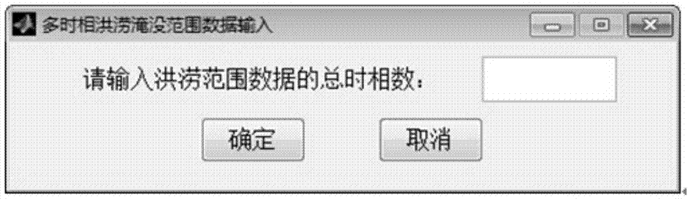
[0081] The input module mainly realizes the input and display of multi-temporal flood submersion range data and its time parameters, water level parameters and other attribute information. First, it is necessary to determine the total time phase of the flood submersion range data (such as image 3 shown); secondly, input the time parameters (year, month, day, hour) and water level parameters (required to keep two decimal places) information of the flood submersion range data in each time phase, the former determines the start and end time of flood submersion duration information extraction, and the latter The former determines the flood rise and fall mode in the flood inundation duration information extraction model (such as Figure 4-7 Shown are four groups of flood submersion range data in different time periods). After the initial information is input, the correspondi...


PUM


Abstract

The invention relates to a flood submergence duration simulation system and method based on remote sensing. The method comprises the steps that an information reading module reads remote sensing information; an information extraction module extracts a flood submerged area through the remote sensing information to obtain multidate high time resolution flood submerged area data; a submerged area calculation module calculates a flood outline to obtain an evolution result of the flood submerged area; a submerged duration calculation module calculates flood submerged duration information; an output module outputs a thematic map. The system and method take time interval information collected by a remote sensing satellite as an input and obtain information of any flood submerged area of any time interval and the flood submerged duration information by using a level set calculation method, predictive information of the flood submerged area can be simulated by manually inputting water level threshold information, after a flood disaster happens, the rising and receding process of the flood submerged area can be effectively simulated through a submerged area map and a duration map, and damage caused by the disaster can be evaluated in time.

Description

technical field [0001] The invention relates to the technical field of water conservancy information, in particular to a flood submersion duration simulation system and method based on remote sensing. Background technique [0002] Floods have always had a significant impact on human survival and development, and the occurrence of a large flood often brings serious casualties and property losses to people. Whether it is the forecast of flood danger, the loss assessment after the disaster, or even the comprehensive management of the watershed, it is all based on the understanding of the characteristics of the flood, the most important of which is the evolution law of the flood. [0003] Flood evolution is based on the conditions of the underlying surface of the river, and according to the flood-related hydrological parameters measured by the hydrological station at the upstream section, the movement law of the flood along the river is analyzed, and after a series of calculatio...

Claims


Application Information

Patent Timeline
Patent Type & Authority Applications(China)
IPC IPC(8): G06Q10/04
CPCY02A10/40
Inventor 黄诗峰李国庆李小涛于文洋李蓉张连翀陈德清王伶俐侯鹏马建威孙亚勇
Owner CHINA INST OF WATER RESOURCES & HYDROPOWER RES
Why Eureka
Try Eureka