
A method for establishing a three-dimensional virtual reality demonstration

A technology of 3D virtual and establishment method, which is applied in the field of establishment of 3D virtual reality demonstration to achieve the effect of fast geometric query and processing speed and improved fidelity

Inactive Publication Date: 2019-02-19
NORTHEAST FORESTRY UNIVERSITY
View PDF6 Cites 0 Cited by
  • Summary
  • Abstract
  • Description
  • Claims
  • Application Information

AI Technical Summary

Problems solved by technology

[0027] The purpose of the embodiment of the present invention is to provide a method for establishing a 3D virtual reality demonstration, aiming at solving the key problems in the process of 3D visualization construction of roads

Method used


Image

  • A method for establishing a three-dimensional virtual reality demonstration
  • A method for establishing a three-dimensional virtual reality demonstration
  • A method for establishing a three-dimensional virtual reality demonstration

Examples


specific Embodiment

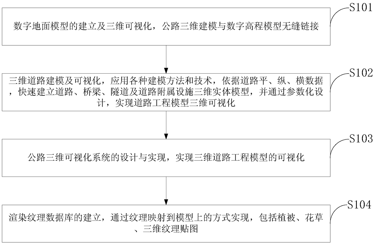
[0079] 1. Establishment of digital ground model and 3D visualization

[0080] 1.1 Digital Terrain Model (DTM) concept:

[0081] Digital Terrain Model (DTM), referred to as DTM, is a digital representation of various information such as terrain surface shape with a large number of three-dimensional coordinates x, y, z. Due to the different distribution forms of the original data points of the digital model, the different methods of data acquisition, the different methods of data processing and interpolation, and the different final output formats, there are many types of digital ground models. The organization form, data structure and data processing method of the digital model depend on the distribution form of the original terrain data. Therefore, according to the distribution form of the known data points in the digital model, the digital model type can be divided into regular digital model and irregular numbers. Planning digital modeling means that there is a fixed connec...


PUM


Abstract

The invention discloses a method for establishing a three-dimensional virtual reality demonstration. The method solves the seamless connection problem of three-dimensional road modeling and a digital elevation model, and road terrain three-dimensional visualization relates to the problem of terrain modeling, the problem of road modeling and the problem about how to achieve seamless splicing of the terrain modeling and the road modeling. Various modeling methods and technologies are applied to the three-dimensional road modeling and visualization, a three-dimensional entity model of a road, a bridge, a tunnel, road ancillary facilities and the like is quickly established according to the flat, longitudinal and transverse data of the road, and three-dimensional road engineering model visualization is realized through parametric design. The three-dimensional road engineering model visualization is realized through the design and implementation of a three-dimensional road visualization system. A rendering texture database is established by the way of mapping texture onto the model. Hence, in order to enable the model visualization to truly reflect a real object scene, it is necessary to establish the texture database rich enough, the texture database includes vegetation, flowers and plants, three-dimensional texture maps and the like, and the system visual fidelity is improved continuously.

Description

technical field [0001] The invention belongs to the technical field of highway ecological monitoring, in particular to a method for establishing a three-dimensional virtual reality demonstration. Background technique [0002] Transportation is the lifeblood of the national economy and the "leader" to promote the development of the national economy. At present, my country's highway construction is in an unprecedented high-speed development period, and the relationship between the benefit and quality of highway construction is very important. Route design is a very important link. The optimal design of modern highway routes has broken through the concept in the traditional sense. It not only requires short travel time and low engineering costs, but also coordinates with the surrounding social, cultural and natural environments. economic, cultural and natural landscape, ecological environment and other factors. Highway ecological monitoring is to grasp the actual situation of...

Claims


Application Information

Patent Timeline
Patent Type & Authority Patents(China)
IPC IPC(8): G06T17/00G06T15/04
Inventor 吴学伟何东坡姜利
Owner NORTHEAST FORESTRY UNIVERSITY
Learn More