Geocoding-free rapid image splicing method of low-altitude unmanned plane

A fast splicing and geocoding technology, applied in image data processing, graphics and image conversion, instruments, etc., can solve the problem of increased calculation

Inactive Publication Date: 2015-08-05
WUHAN UNIV
View PDF5 Cites 19 Cited by
  • Summary
  • Abstract
  • Description
  • Claims
  • Application Information

AI Technical Summary

Problems solved by technology

This method reduces the restrictions on camera movement when capturin...

Method used


Image

  • Geocoding-free rapid image splicing method of low-altitude unmanned plane
  • Geocoding-free rapid image splicing method of low-altitude unmanned plane
  • Geocoding-free rapid image splicing method of low-altitude unmanned plane

Examples


Embodiment Construction

[0031] In order to facilitate those of ordinary skill in the art to understand and implement the present invention, the present invention will be described in further detail below in conjunction with the accompanying drawings and embodiments. It should be understood that the implementation examples described here are only used to illustrate and explain the present invention, and are not intended to limit this invention.

[0032] During specific implementation, the technical solution of the present invention can use computer software technology to realize the automatic operation process. The present embodiment uses the video stream of the MPEG-1 format that data source is 704 * 576, and specific implementation steps are as follows:

[0033] Step 1: Extract key frame images from the video stream to obtain all images to be stitched.

[0034] During specific implementation, existing technologies may be used for extracting key frame images. The embodiment uses the software Micros...


PUM


Abstract

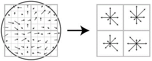
The invention relates to a geocoding-free rapid image splicing method of a low-altitude unmanned plane. A key frame image is extracted from a video to carry out geocoding-free rapid image splicing to generate a panoramic image. The method comprises the following steps: extracting a key frame image from a video stream to obtain all to-be-spliced images; carrying out feature point extraction including establishing a multi-dimensional space unit, constructing a pyramid image, determining a key point position, and removing an unstable point on all to-be-spliced images and carrying out screening on the key point by using a SUSAN algorithm to obtain a final feature point; carrying out feature matching according to respective feature points of a corresponding reference image and a to-be-matched image; and carrying out smoothening on the to-be-spliced images by using a gain compensation method, carrying out weighted average fusion on spliced overlapped areas to eliminate seams and sawteeth, and carrying out splicing to generate a panoramic image. According to the technical scheme, the method can be applied to fields of emergency surveying and mapping, disaster prevention and mitigation, land monitoring, emergency monitoring, pipeline layout and inspection of the oil sector, and circuit layout and power line inspection of the power sector and the like.

Description

technical field [0001] The invention belongs to the field of video image processing and image processing, and relates to a video frame image extraction technology and image automatic splicing technology, in particular to a low-altitude unmanned aerial photography remote sensing system video monitoring and image fast splicing correction technology without geographic coding. Background technique [0002] With the advancement of science and technology and the sustainable development of society, the demand for land and resources in national economic construction is increasing day by day. Accurate, fast and economical acquisition of geographic information is the prerequisite for realizing the scientific development and management of land and resources. The first part of the strategy. There are many geological disasters and other emergencies in our country. How to quickly and accurately obtain on-site information and provide decision-making basis for decision-makers has been a pro...

Claims


Application Information

Patent Timeline
IPC IPC(8): G06T3/40
Inventor 潘励谈家英张羽飞
Owner WUHAN UNIV
Why Eureka
Try Eureka