Satellite side-sway angle obtaining method based on image characteristics

An acquisition method and image feature technology, applied in the field of remote sensing image processing, can solve the problems of not calculating the satellite roll angle, difficult to obtain the satellite roll angle, and undisclosed satellite ephemeris data. The effect of the simple method

Active Publication Date: 2015-08-12
CHINA CENT FOR RESOURCES SATELLITE DATA & APPL
View PDF5 Cites 13 Cited by
  • Summary
  • Abstract
  • Description
  • Claims
  • Application Information

AI Technical Summary

Problems solved by technology

However, for users of remote sensing satellite data, the ephemeris data of satellites is not public, so it is difficult to obtain the roll angle of satellites, and there is currently no method for calculating the roll angle of satellites based on remote sensing image data

Method used


Image

  • Satellite side-sway angle obtaining method based on image characteristics
  • Satellite side-sway angle obtaining method based on image characteristics
  • Satellite side-sway angle obtaining method based on image characteristics

Examples


Embodiment

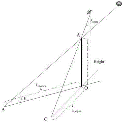
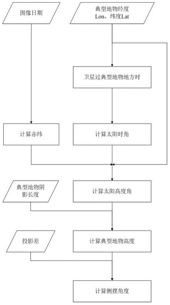
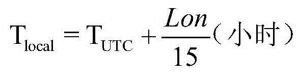
[0057] Select the image of Gaofen-1 satellite on August 5, 2013 for calculation, use the 2m panchromatic resolution image, select the typical feature in the image as the Oriental Pearl TV Tower, find the longitude of the TV tower from the image as east longitude 121.5 degrees , the latitude is 31.23 degrees, the shadow length of the TV tower measured from the figure is 168 meters, and the projection difference is 125.5 meters. The UTC time is calculated based on the nominal orbit of the Gaofen-1 satellite. The UTC time of the feature is 2:56:39.

[0058] According to the existing information and measurement data of the image, it can be calculated:

[0059] Solar hour angle T angle =(12-(2+56 / 60+39 / 3600))*15=14.3375 degrees;

[0060] Declination δ=arcsin(0.39795*cos(0.98563*(217-173)))=16.8157 degrees;

[0061] Sun altitude angle H=arcsin(sin(31.23)*sin(16.8157)+

[0062] cos(31.23)*cos(16.8157)*cos(14.3375)=70.6110 degrees;

[0063] Building height Height=168*tan(70.611)=...


PUM


Abstract

A satellite side-sway angle obtaining method based on the image characteristics comprises the following steps: (1) obtaining the imaging date of a remote sensing image; (2) choosing a proper landmark on the remote sensing image, and obtaining latitude information of the landmark; (3) according to the parameters of the satellite orbit, obtaining the imaging local time (Tlocal) of the latitude of the landmark; (4) according to Tlocal, calculating the solar time angle (Tangle); (5) calculating the solar declination [delta] of the imaging date; (6) calculating the solar altitude according to [delta], Tangle, and the latitude (Lat) of the landmark; (7) measuring the shadow length (Lshadow) of the landmark on the remote sensing image, and calculating the height of the landmark (Height) by combining the solar altitude; (8) measuring the projection difference (Lproject) of the landmark on the remote sensing image, and finally calculating the side-sway angle (Sangle) when satellite imaging is carrying out according to the Height. The provided method can obtain the side-sway angle of a satellite through a remote sensing image by using the remote sensing satellite imaging mechanism and sunshine geometrical relationships, when the ephemeris data cannot be obtained.

Description

technical field [0001] The invention belongs to the field of remote sensing image processing, and relates to a method for calculating a side swing angle of a satellite during remote sensing data collection according to the imaging time of the remote sensing image and the characteristics of tall buildings in the remote sensing image. Background technique [0002] At present, most remote sensing satellites adopt sun-synchronous homing orbits, and the homing characteristics of sun-synchronous homing orbits can ensure that the sub-satellite points will coincide after a few days. However, the sun-synchronous return orbit usually has a long return period, and the return period of high-resolution remote sensing satellites generally ranges from 40 to 100 days. The maneuverability of remote sensing satellites can improve the timeliness of satellite data acquisition, which requires breaking the conventional sub-satellite point shooting mode and sideways the entire satellite or the cam...

Claims


Application Information

Patent Timeline
Patent Type & Authority Applications(China)
IPC IPC(8): G01C1/00
CPCG01C1/00
Inventor 易维王静巧曾湧彭勇钊
Owner CHINA CENT FOR RESOURCES SATELLITE DATA & APPL
Why Eureka
Try Eureka