Method utilizing bus vehicle GPS data for evaluating road traffic condition dynamically

A technology of GPS data and road traffic, which is applied in the traffic control system of road vehicles, traffic flow detection, traffic control system, etc., and can solve the problems of the influence of the time spent on the average speed and the influence of speed without consideration

Inactive Publication Date: 2015-08-19
北京市交通运行监测调度中心 +1
View PDF5 Cites 25 Cited by
  • Summary
  • Abstract
  • Description
  • Claims
  • Application Information

AI Technical Summary

Problems solved by technology

However, this method does not consider the influence of the speed of the bus when it stops at the platform. In practice, when the bus stops at the platform, ...

Method used


Image

  • Method utilizing bus vehicle GPS data for evaluating road traffic condition dynamically
  • Method utilizing bus vehicle GPS data for evaluating road traffic condition dynamically
  • Method utilizing bus vehicle GPS data for evaluating road traffic condition dynamically

Examples


Embodiment Construction

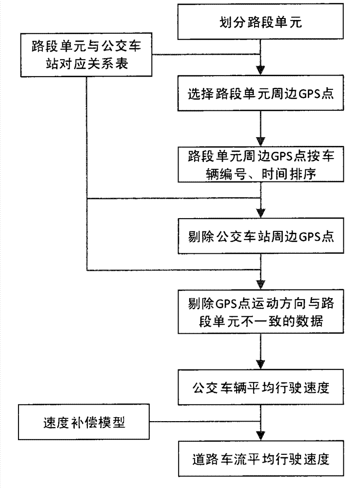
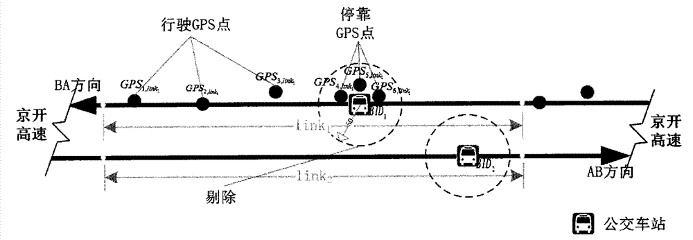
[0022] Below in conjunction with the accompanying drawings, the preferred embodiment is further described in detail. There are several bus lines operating on the main line of the Jingkai Expressway with two-way 6 lanes. The implementation process is as attached image 3 .

[0023] Step 1: Divide Jingkai Expressway into two directions, uplink and downlink, see image 3 In the two directions of AB and BA, the uplink and downlink directions are divided into multiple independent road section units, see the link in the figure 1 and link 2 , to calculate the azimuth angle of the road section unit (the angle between the line connecting the starting point and the end point of the road section unit and the direction of true north is taken as the direction of true north as 0 degrees),

[0024] Step 2: Create a table of correspondence between link units and bus stops.

[0025] According to the road section unit and the geographical space position of the bus station, establish the ow...


PUM


Abstract

The invention relates to a method utilizing bus vehicle GPS data for evaluating road traffic condition dynamically and belongs to the field of intelligent traffic. Vehicle GPS data is recorded when a bus equipped with a GPS device is driving on a road, wherein the data includes vehicle location information and generated time information. When calculating, a GPS point in the data is converted to a space coordinate point and is matched to the road. GPS points in a specific range of the road are obtained in a timing period and then the GPS points are matched with bus stops with known location information. Invalid GPS points around the bus stops are removed. Then the valid GPS points are utilized for azimuth angle calculation. Through the comparison with a matched road azimuth angle, the driving direction of the bus is determined. Finally, according to the positions of the valid GPS points and the time information, the average driving speed of the vehicle is calculated and is modified to the a road traffic operation speed by utilizing a speed compensation model. Compared the road traffic operation speed with a traffic state section scale, the road traffic operation state is obtained.

Description

technical field [0001] The invention relates to traffic information processing technology in the field of intelligent traffic. The GPS positioning data recorded by the GPS equipment on the bus can be used to analyze the road traffic operation status. Background technique [0002] The development of my country's economy and society has brought about a rapid and rapid increase in the number of motor vehicles. The supply of transportation infrastructure cannot meet the needs of motor vehicles, resulting in serious traffic congestion. Discovering traffic jams in advance and providing travelers with information on congested routes can better guide travelers to choose a reasonable travel route. At present, the GPS data on the bus is used to evaluate the road traffic status, mainly using the GPS data on both sides of the road boundary to estimate the boundary time of the road section, so as to obtain the travel time of the single vehicle section, and calculate the travel speed of ...

Claims


Application Information

Patent Timeline
IPC IPC(8): G08G1/01G08G1/052G01S19/42
CPCG01S19/42G08G1/0133G08G1/052
Inventor 张可陈艳艳李静赖见辉翟佳琪赵净洁魏攀一耿松麟赵箐杨子帆方珊珊张建强毛力增何卓王少华
Owner 北京市交通运行监测调度中心
Why Eureka
Try Eureka