Extraction method of plant community spatial structure

A technology of spatial structure and plant community, applied in the field of remote sensing image processing, can solve the problem of no large-scale and systematic monitoring method, and achieve the effect of improving objectivity, avoiding subjectivity, and reducing monitoring costs.

Inactive Publication Date: 2017-07-07
INST OF REMOTE SENSING & DIGITAL EARTH CHINESE ACADEMY OF SCI
View PDF4 Cites 1 Cited by
  • Summary
  • Abstract
  • Description
  • Claims
  • Application Information

AI Technical Summary

Problems solved by technology

In summary, apart from microscopic ground surveys, no large-scale and systematic monitoring methods have been proposed for the spatial structure of plant communities.

Method used


Image

  • Extraction method of plant community spatial structure
  • Extraction method of plant community spatial structure
  • Extraction method of plant community spatial structure

Examples


Embodiment Construction

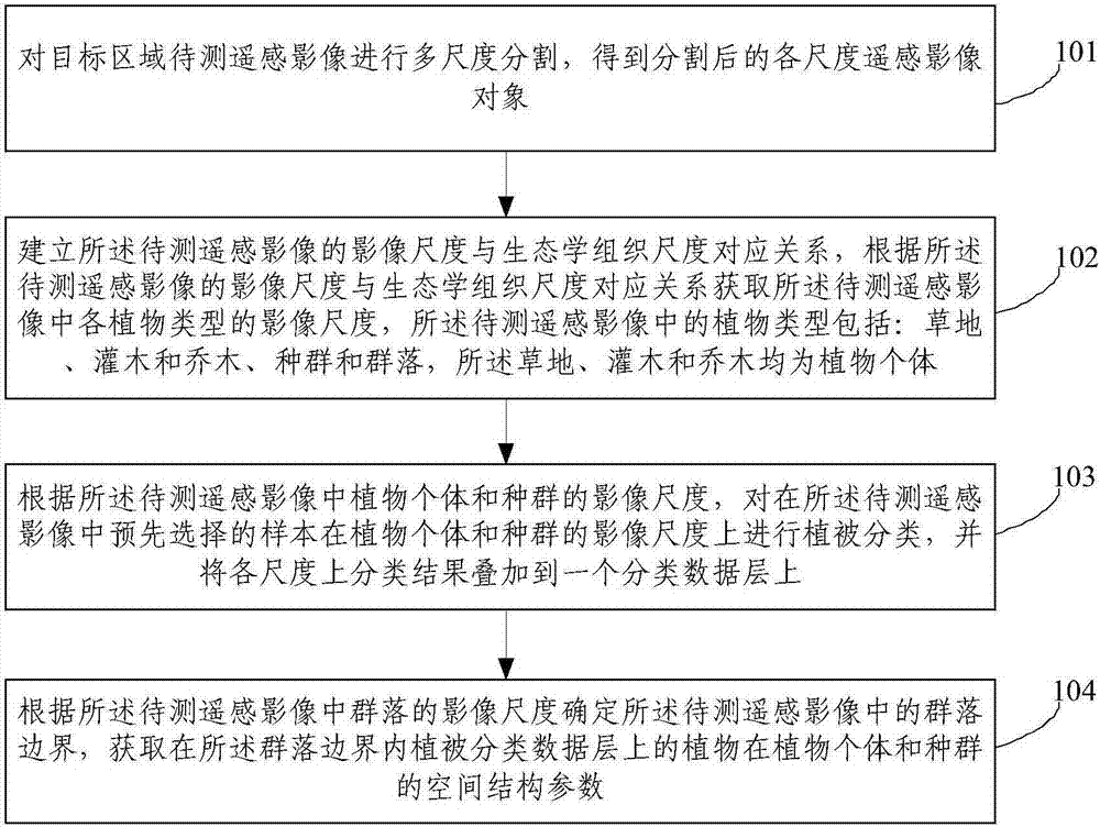
[0074] In order to make the objectives, technical solutions and advantages of the embodiments of the present invention clearer, the following will clearly and completely describe the technical solutions in the embodiments of the present invention in conjunction with the accompanying drawings in the embodiments of the present invention. Obviously, the described embodiments It is only a part of the embodiments of the present invention, not all the embodiments. Based on the embodiments of the present invention, all other embodiments obtained by those of ordinary skill in the art without creative work shall fall within the protection scope of the present invention.

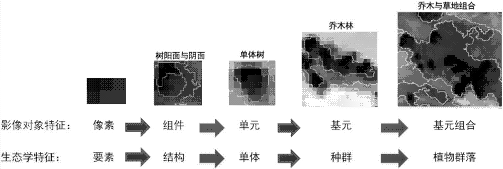
[0075] The present invention is based on the basic idea of ​​multi-scale object fitting and the basic idea of ​​statistics of the spatial parameters of plant individuals and populations within the scale of community organization. The image pixels are transformed into objects, and the objects have semantic features. The ...


PUM


Abstract

The invention provides a method for extracting a phytocoenosium spatial structure. The method comprises: performing multi-resolution segmentation of a to-be-tested remote-sensing image in a target area to obtain remote-sensing image objects with different resolutions; establishing a corresponding relation between an image resolution of the to-be-tested remote-sensing image and an ecological organization resolution to obtain an image resolution of each plant type in the to-be-tested remote-sensing image, wherein the plant types include a meadow, a shrub, an arbor, a population and a group, wherein the meadow, the shrub, and the arbor are plant individuals; performing vegetation classification of a pre-selected sample of the to-be-tested remote-sensing image in plant individual and population image resolution according to the plant individuals and the population image resolution; summing the classification result of each resolution to a grouped data layer; and calculating plant individuals and parameters of a population spatial structure in a group resolution object boundary. The method for extracting the phytocoenosium spatial structure is relatively accurate, and is low in monitoring cost and high in objectivity.

Description

Technical field [0001] The invention relates to the technical field of remote sensing image processing, in particular to a method for extracting the spatial structure of a plant community. Background technique [0002] At present, the survey of plant community structure mostly uses traditional, small-scale sampling statistical methods or large-scale remote sensing monitoring methods, including vegetation type, vegetation index, height and other architectural features, but lacks the size, size, and structure of ecosystems at various scales. Identification of form, organization and pattern. There are two reasons for this: 1) Scale issues. The level of ecological organization follows the natural hierarchical system, from the organizational scale of plant configuration (branches, leaves), individuals, populations, communities, ecosystems, and ecological landscapes. At different scales, patterns and processes often have different characteristic laws. The uncertainty of scale deduct...

Claims


Application Information

Patent Timeline
Patent Type & Authority Patents(China)
IPC IPC(8): G06T7/11G06T7/49
CPCG06T7/11G06T7/49G06T2207/10032G06T2207/30188
Inventor 张磊尹锴
Owner INST OF REMOTE SENSING & DIGITAL EARTH CHINESE ACADEMY OF SCI
Why Eureka
Try Eureka