Universal GPS indoor and outdoor positioning system and method

An indoor and outdoor positioning, GPS signal technology, applied in the field of satellite navigation and positioning, can solve the problems of user inconvenience, positioning algorithm difference, increased cost, etc., and achieve the effect of simple implementation and low cost

Active Publication Date: 2015-09-09
GUILIN UNIV OF ELECTRONIC TECH
View PDF6 Cites 26 Cited by
  • Summary
  • Abstract
  • Description
  • Claims
  • Application Information

AI Technical Summary

Problems solved by technology

However, indoor pseudolites are fixed at a certain fixed position, while GPS satellites move periodically along the orbit, and their positioning algorithms are different.
Therefore, the traditional pseudolite positioning cannot use the GPS receiver for direct positioning, but needs to modify some programs in

Method used


Image

  • Universal GPS indoor and outdoor positioning system and method
  • Universal GPS indoor and outdoor positioning system and method
  • Universal GPS indoor and outdoor positioning system and method

Examples


Embodiment Construction

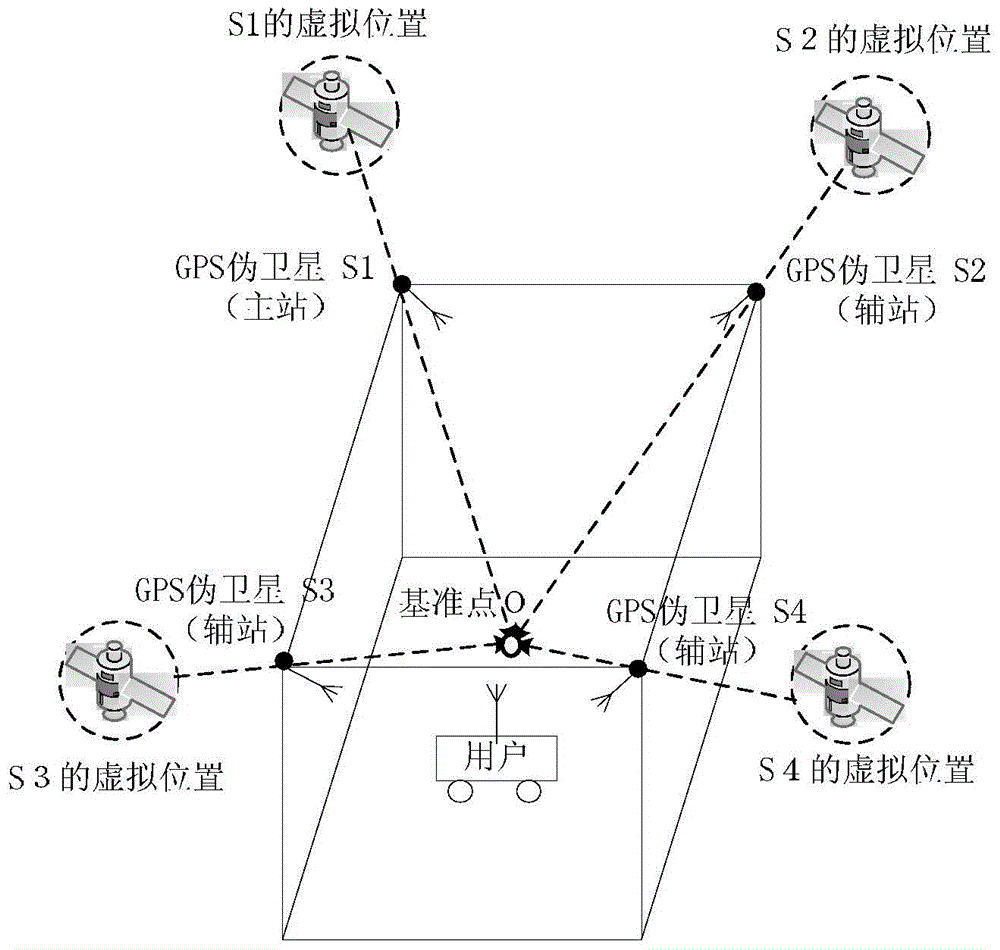
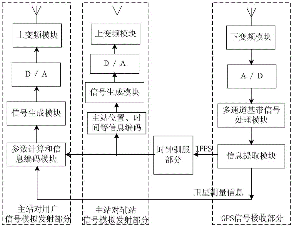
[0026] A general GPS indoor and outdoor positioning system, such as figure 1 As shown, the system includes one GPS pseudolite master station (S1 in the figure), three or more GPS pseudolite auxiliary stations (S2-S4 in the figure) and user receivers. First, the positions of the pseudolite main station and auxiliary station are obtained through precise measurement. Secondly, the pseudolite master station can receive outdoor GPS signals in real time, obtain the PPS second pulse signal and the current visible satellite number, satellite position and other information, and use the PPS second pulse to tame the clock of the local pseudolite master station, and use the local tame clock to synchronously generate two The radio frequency signal is sent all the way to the user and all the way to the pseudolite auxiliary station. Thirdly, the pseudolite auxiliary station receives the signal sent by the pseudolite master station, realizes the synchronization of the local clock of each pse...


PUM


Abstract

The invention discloses a universal GPS indoor and outdoor positioning system and method. The universal GPS indoor and outdoor positioning system comprises a GPS pseudo satellite main station, three or more GPS pseudo satellite auxiliary stations, and a user receiver. The GPS pseudo satellite main station receives outdoor GPS signals in real time, acquires PPS (pulse per second) signal and a current visible satellite parameter, disciplines the clock of a local pseudo satellite main station by means of the PPS signal, synchronously generates two radiofrequency signals by means of a local disciplined clock, sends one radiofrequency signal to a user, and send the other radiofrequency signal to the GPS pseudo satellite auxiliary stations. The GPS pseudo satellite auxiliary stations receive signal sent from the GPS pseudo satellite main station, achieve synchronization between the local clocks of the GPS pseudo satellite auxiliary stations and the clock of the GPS pseudo satellite main station, and synchronously generate virtual GPS satellite simulating signals. The user synchronously receives the virtual GPS satellite signals sent from the visible pseudo satellite main station and pseudo satellite auxiliary stations and completes indoor and outdoor positioning of the user in real time. The universal GPS indoor and outdoor positioning system is simple and is not required to change the software and the hardware of a conventional GPS receiver.

Description

technical field [0001] The invention relates to the field of satellite navigation and positioning, in particular to a general GPS indoor and outdoor positioning system and method. Background technique [0002] Due to some congenital factors of the satellite navigation system itself, there are some insurmountable weaknesses. For example, for indoor users, due to the blocking of surrounding walls or other obstacles, when the satellite signal reaches the room, the satellite signal is already very weak, and it is impossible to complete the positioning with a traditional GNSS receiver. [0003] At present, pseudolite is a method to solve indoor positioning. Since the GPS pseudolite positioning system emits signals similar to GPS satellites, its positioning algorithm is also based on the principle of GPS positioning. However, indoor pseudolites are fixed at a certain fixed position, while GPS satellites move periodically along the orbit, and their positioning algorithms are diffe...

Claims


Application Information

Patent Timeline
IPC IPC(8): G01S19/01G01S19/42
CPCG01S19/01G01S19/42G01S19/11
Inventor 孙希延纪元法符强肖建明严素清吴孙勇王守华邓洪高廖桂生
Owner GUILIN UNIV OF ELECTRONIC TECH
Why Eureka
Try Eureka