Practical leaf area index remote sensing inversion method

A technology of leaf area index and remote sensing inversion, which is applied in the field of remote sensing inversion of leaf area index, and can solve the problems of non-convergence and wrong inversion results.

Active Publication Date: 2015-09-09
INST OF REMOTE SENSING & DIGITAL EARTH CHINESE ACADEMY OF SCI
View PDF4 Cites 9 Cited by
  • Summary
  • Abstract
  • Description
  • Claims
  • Application Information

AI Technical Summary

Problems solved by technology

The main disadvantage of this method is that the inverse solution of the model is ill-conditioned, and some inverse functions do not

Method used


Image

  • Practical leaf area index remote sensing inversion method
  • Practical leaf area index remote sensing inversion method
  • Practical leaf area index remote sensing inversion method

Examples


Embodiment Construction

[0019] A kind of practical leaf area index remote sensing inversion method described in this embodiment, it comprises concrete steps as follows:

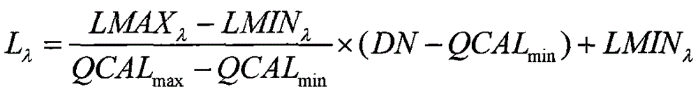
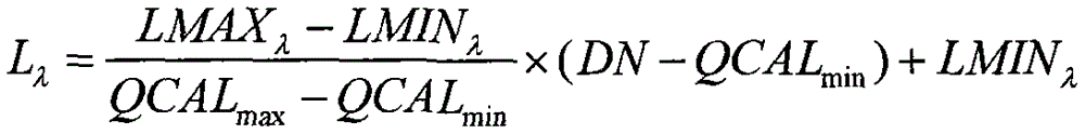
[0020] Step 1. Perform radiometric calibration on the remote sensing image, and convert the DN value of the image into radiance, specifically:

[0021] L λ = LMA X λ - LMI N λ QCAL max - QC AL min × ( DN - QCA L min ) + LMIN λ

[0022] L λ is the calibrated spectral radiance, in w / (m 2 μm sr); DN is the stora...


PUM


Abstract

The invention discloses a practical leaf area index remote sensing inversion method. According to the method, a lookup table is built in a simulation manner on the base of a geometrical optics model, then, an LAI inversion model is built, a variable end element spectral mixing model is used in cooperation, and finally, the LAI inversion result is obtained. The practical leaf area index remote sensing inversion method is completely based on remote sensing images, no field measured LAI data are needed, and therefore, the LAI inversion cost is reduced; calculation is easy and convenient, and the method is a practical LAI remote sensing inversion method.

Description

technical field [0001] The invention relates to the technical field of remote sensing data processing, in particular to a remote sensing inversion method of leaf area index (LAI). Background technique [0002] Leaf Area Index (LAI), as a parameter for plant population and community growth analysis, has become an important botanical parameter and evaluation index since it was proposed in the 1940s, and has been widely used in agriculture, forestry, botany, Ecology, global carbon cycle and other fields have been widely used. [0003] The acquisition methods of LAI include ground survey method and remote sensing estimation method. The ground measurement method has a large workload and can only obtain LAI data of limited points, and cannot obtain surface LAI data. Therefore, it is far from enough to rely on ground measurement for large-area LAI research. Remote sensing technology provides a way for large-area LAI research. Feasible ways, using remote sensing technology to inve...

Claims


Application Information

Patent Timeline
IPC IPC(8): G06F17/50
Inventor 张兆明何国金龙腾飞王猛猛王桂周张晓美
Owner INST OF REMOTE SENSING & DIGITAL EARTH CHINESE ACADEMY OF SCI
Why Eureka
Try Eureka