Forest fire trend pre-judging method based on power grid GIS and referring to meteorological data

A GIS map and power grid technology, which is applied in the field of trend prediction based on the combination of wildfires and meteorology based on power grid GIS, can solve the problems of geographic space confusion, unintuitive display, and inability to effectively see the status of material allocation, so as to improve disposal efficiency. Effect

Active Publication Date: 2015-10-21
山东弘石互联网科技有限公司
View PDF4 Cites 16 Cited by
  • Summary
  • Abstract
  • Description
  • Claims
  • Application Information

AI Technical Summary

Problems solved by technology

The usual material allocation method is to enter the system in the form of text data for material allocation. This resource allocation method only processes the logical relationship of resource data in the information system. Its display is not intuitive, and it is easy to cause geographic space confusion. On the way of allocation, it is impossible to effectively see the allocation status of materials, where they have arrived, whether the route is reasonable, etc.; operators or decision makers need to have better spatial layout capabilities

Method used


Image

  • Forest fire trend pre-judging method based on power grid GIS and referring to meteorological data

Examples


Embodiment Construction

[0057] The present invention will be further described below in conjunction with the accompanying drawings and embodiments.

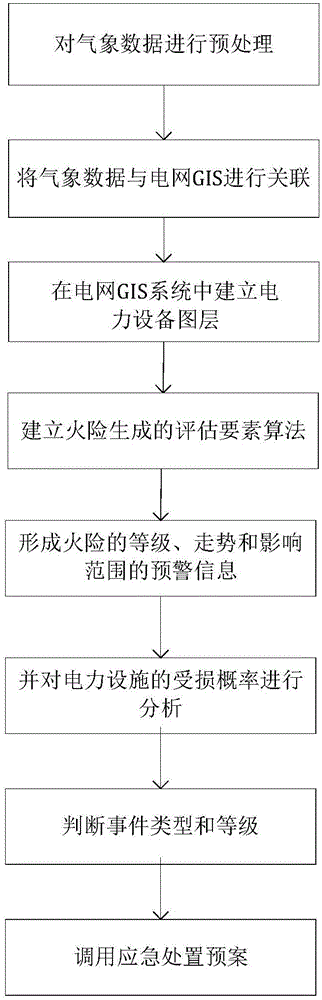
[0058] Such as figure 1 As shown, a trend prediction method based on the combination of wildfire and meteorology based on power grid GIS includes the following steps:

[0059] (1) Preprocess the meteorological data, connect the real-time monitored meteorological information data to the power grid GIS system, and store it in the meteorological database of the power grid GIS system;

[0060] (2) Associate the meteorological data with the GIS of the power grid, and superimpose the meteorological elements on the GIS map; project the coordinate information of the meteorological monitoring station on the GIS map to the GIS map, and establish the corresponding meteorological layer according to the coordinate information.

[0061] (3) Store the coordinate information of the power facilities in the power equipment database of the power grid GIS system, and esta...


PUM


Abstract

The invention discloses a forest fire trend pre-judging method based on a power grid GIS and referring to meteorological data. The method comprises the following steps of preprocessing meteorological data, making the meteorological data linked with the power grid GIS, and establishing a power equipment map layer in the power grid GIS system; setting up an assessing factor algorithm for forest fire risk generation; matching meteorological factors and fire risk generation factors; pre-judging power facilities affected by forest fire and analyzing the power facility damage probability; determining the event type and grade; determining the forest fire impact range and the power facilities nearest to the forest fire center; and invoking an emergency handling plan and performing material allotting on forest fire sites. By combining basic data and spatial data, the method makes the basic data have spatial displaying conditions. The handling efficiency of emergency handling personnel is improved. A strong support for emergency event handling is provided.

Description

technical field [0001] The invention relates to a trend prediction method based on the combination of wildfire and meteorology based on power grid GIS. Background technique [0002] In recent years, various industries based on GIS map application systems emerge in an endless stream, and these systems are mainly used in transportation, electric power industry, water conservancy industry and communication industries. The GIS map application system displays computer data information graphically, intuitively and in a variety of ways. This type of GIS map-based application system is easier and faster to operate in terms of business processing functions, and improves the user experience of the application system. decision-making efficiency. [0003] Forest fires are characterized by suddenness, randomness of disasters, and huge losses in a short period of time. Mountain fires usually cause melting insulators, increased wire sag, deformation of tower materials, and changes in foun...

Claims


Application Information

Patent Timeline
Patent Type & Authority Applications(China)
IPC IPC(8): G06Q10/04G06Q50/06
CPCY02A90/10
Inventor 邓国强吴戆陈萌陈存香
Owner 山东弘石互联网科技有限公司
Why Eureka
Try Eureka