
Intelligent active image acquisition and update system and method

A technology of image acquisition and image update, applied in the field of image information, can solve the problems of low efficiency of street view maps, reduced update frequency of map data, slow update speed of street view, etc., to achieve stable and controllable costs, high degree of intelligence, and strong systematization Effect

Inactive Publication Date: 2015-10-21
高域(北京)智能科技研究院有限公司
View PDF10 Cites 24 Cited by
  • Summary
  • Abstract
  • Description
  • Claims
  • Application Information

AI Technical Summary

Problems solved by technology

However, the existing large-scale image information collection and update work based on aerial photography is often started based on some specific factors, such as artificially designated by the operator, it is necessary to photograph a certain line or a certain range, and collect the required images information; then the next collection work time may start based on another uncertain factor
This kind of image information collection method is full of randomness, and it is difficult to fully reflect the whole picture of the entire collected area
[0008] For example, for the street view map system, traditional street view map shooting is limited by many factors, such as manpower, equipment, transportation, etc., so the efficiency of shooting street view maps is very low, the update speed of street view is slow, and the cost is high
At present, the typical data collection method of street view map is to travel by street view shooting car, travel according to the predetermined route, and carry out shooting at the predetermined location. The update frequency of the current street view map is very slow. Even for companies and teams with relatively sufficient financial resources like Google Maps, the map data update frequency is very low, especially when there are more locations on the map that need to be photographed by street view. Then the map data update frequency will be further reduced

Method used


Image

  • Intelligent active image acquisition and update system and method
  • Intelligent active image acquisition and update system and method
  • Intelligent active image acquisition and update system and method

Examples


Embodiment 1

[0050] Embodiment 1. An intelligent active image acquisition and update system.

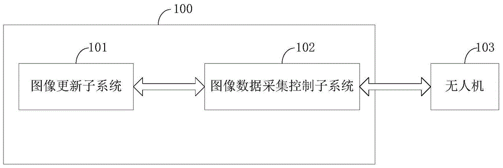
[0051] figure 1 It is a schematic structural diagram of an intelligent active image acquisition and update system in Embodiment 1 of the present invention. Embodiments of the present invention will combine figure 1 Be specific.

[0052] Such as figure 1 As shown, the embodiment of the present invention provides an intelligent active image acquisition and update system 100, including an image update subsystem 101 and an image data acquisition control subsystem 102, the image update subsystem 101 and the image data acquisition control subsystem Two-way communication is possible between subsystems 102, wherein,

[0053] The image update subsystem 101 is adapted to define a preset area and send the data update requirements of the preset area to the image data acquisition control subsystem 102. The definition of the preset area includes determining the geographic information of the area, Record da...

Embodiment 2

[0080] Embodiment 2. An intelligent active image acquisition and update system.

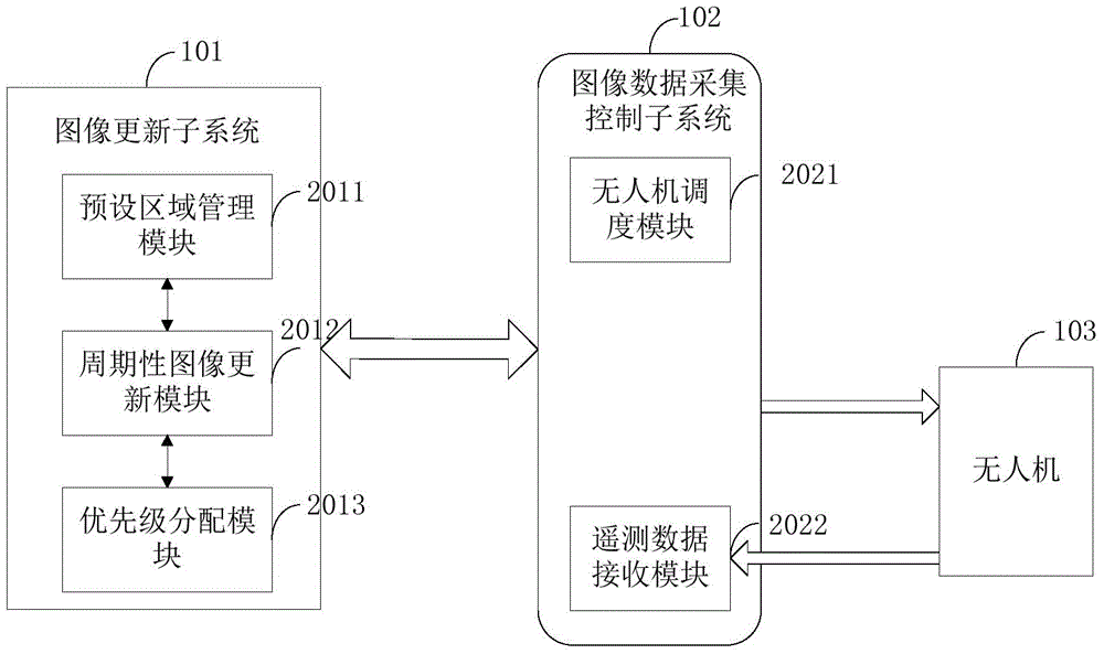
[0081] figure 2It is a schematic structural diagram of an intelligent active image acquisition and updating system according to Embodiment 2 of the present invention. Embodiments of the present invention will combine figure 2 Be specific.

[0082] Such as figure 2 As shown, the embodiment of the present invention provides an intelligent active image acquisition and update system, including an image update subsystem 101, an image data acquisition control subsystem 102 and a drone 103, wherein the image update subsystem 101 is further Including a preset area management module 2011, a periodic image update module 2012, and a priority assignment module 2013, the image data collection control subsystem 102 further includes a drone scheduling module 2021, a telemetry data receiving module 2022, and the image data collection The control subsystem 102 is respectively connected to the image update s...

Embodiment 3

[0093] Embodiment 3. An intelligent active image acquisition and update system.

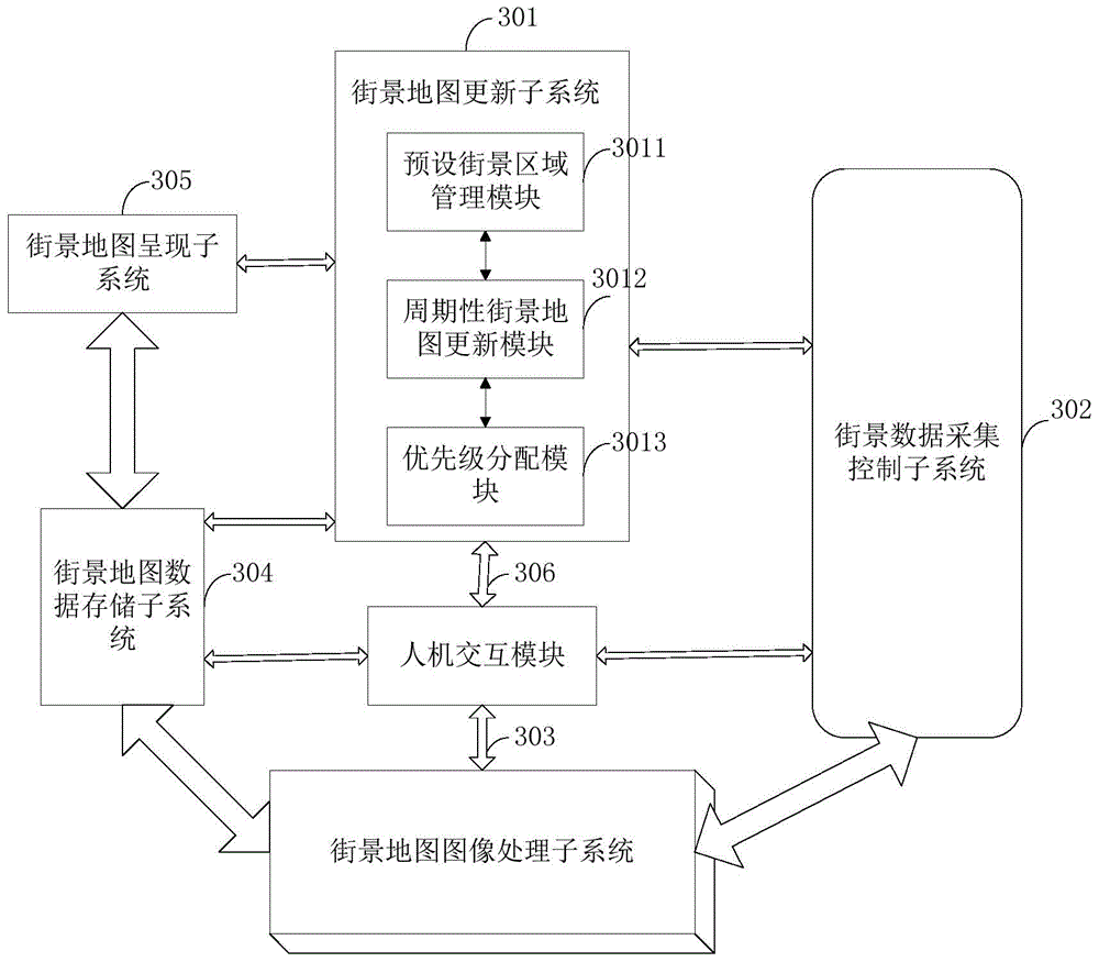
[0094] image 3 It is a schematic structural diagram of an intelligent active image acquisition and update system in Embodiment 3 of the present invention. Embodiments of the present invention will combine image 3 Be specific.

[0095] Such as image 3 As shown, the embodiment of the present invention provides an intelligent active image acquisition and update system, taking street view map data acquisition as an example to describe in detail, including street view map update subsystem 301, street view data acquisition control subsystem 302, street view map image Processing subsystem 303, street view map data storage subsystem 304, street view map presentation subsystem and / or human-computer interaction module 306, wherein,

[0096] The street view map update subsystem 301 is connected to the street view data collection control subsystem 302, the street view map data storage subsystem 304, an...


PUM


Abstract

The invention discloses an intelligent active image acquisition and update system and method and belongs to the technical field of image information. The system comprises an image update subsystem and an image data acquisition control subsystem. The image update subsystem sends a data updating requirement of a preset area to the image data acquisition control subsystem, wherein the preset area comprises geographic information, data updating time and update frequency of the area; and the image data acquisition control subsystem assigns an image acquisition task to an appropriate unmanned aerial vehicle according to preset rules and receives the fed-back telemeasuring data. The problem of wide-range image information data acquisition is solved through aerial photography of the small-size unmanned aerial vehicles under systematic control; through the photography of the unmanned aerial vehicles, acquisition cost is stable and controllable; meanwhile, through the design of route planning and update frequency, multiple unmanned aerial vehicles are allowed to carry out image acquisition simultaneously; the image acquisition process is high in systematization and high in intelligent degree; and image information acquisition and update range and efficiency are effectively managed.

Description

technical field [0001] The invention relates to the field of image information, in particular to an intelligent active image acquisition and update system and method. Background technique [0002] In some existing systems for collecting image information for a specific area, image collection is usually done by manual shooting. The technology to gather imagery information over a large area of ​​a specific location has been slow to develop. [0003] UAVs have a wide range of applications in aerial photography, flight performances, disaster prevention and rescue, scientific investigation and other fields. With the rapid development of electronic technology, small and micro drones have made significant breakthroughs in remote control, battery life, and flight quality, and have become the focus of attention in the field of general aviation that has emerged in recent years, and are generally considered to have good development prospect. Typically, quadcopters have become the pr...

Claims


Application Information

Patent Timeline
Patent Type & Authority Applications(China)
IPC IPC(8): H04N7/18H04N5/232G08C17/02
Inventor 杨珊珊
Owner 高域(北京)智能科技研究院有限公司
Learn More