

A method and system for updating image information in a monitoring area
A technology for monitoring areas and image information, applied in closed-circuit television systems, geographic information databases, input/output to record carriers, etc., can solve the problems of high cost, inflexible installation location, and impossibility of full coverage, etc., and achieve low cost , Improving the effect of real-time performance
- Summary
- Abstract
- Description
- Claims
- Application Information
AI Technical Summary
Problems solved by technology
Method used
Image

Examples
Embodiment 1
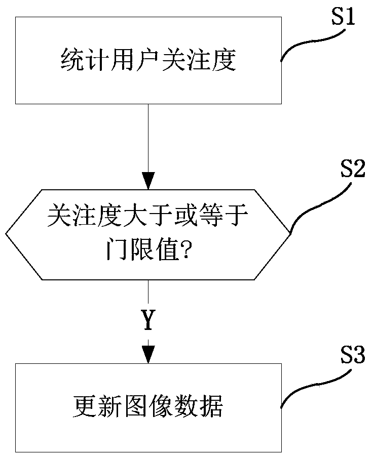
[0042] like figure 1 As shown, this implementation mode discloses a method for updating image information of a monitoring area, including steps:
[0043] Statistical monitoring of user attention at various locations in the monitoring area;
[0044] If the user's degree of attention is greater than or equal to the threshold value, control the mobile camera device to collect images of the corresponding location;
[0045] Update image data.
[0046] With the development of technology, the intelligent collection of images becomes possible. Especially with the development of mobile phone technology, the cost and volume of some ultra-small electronic components have been greatly improved, and mobile camera devices such as multi-rotor aircraft have begun to enter the consumer market. For example, the volume and weight of the multi-rotor aircraft represented by the quadcopter are greatly controlled, and the maneuverability is also high, and combined with the GPS module and some aut...
Embodiment 2
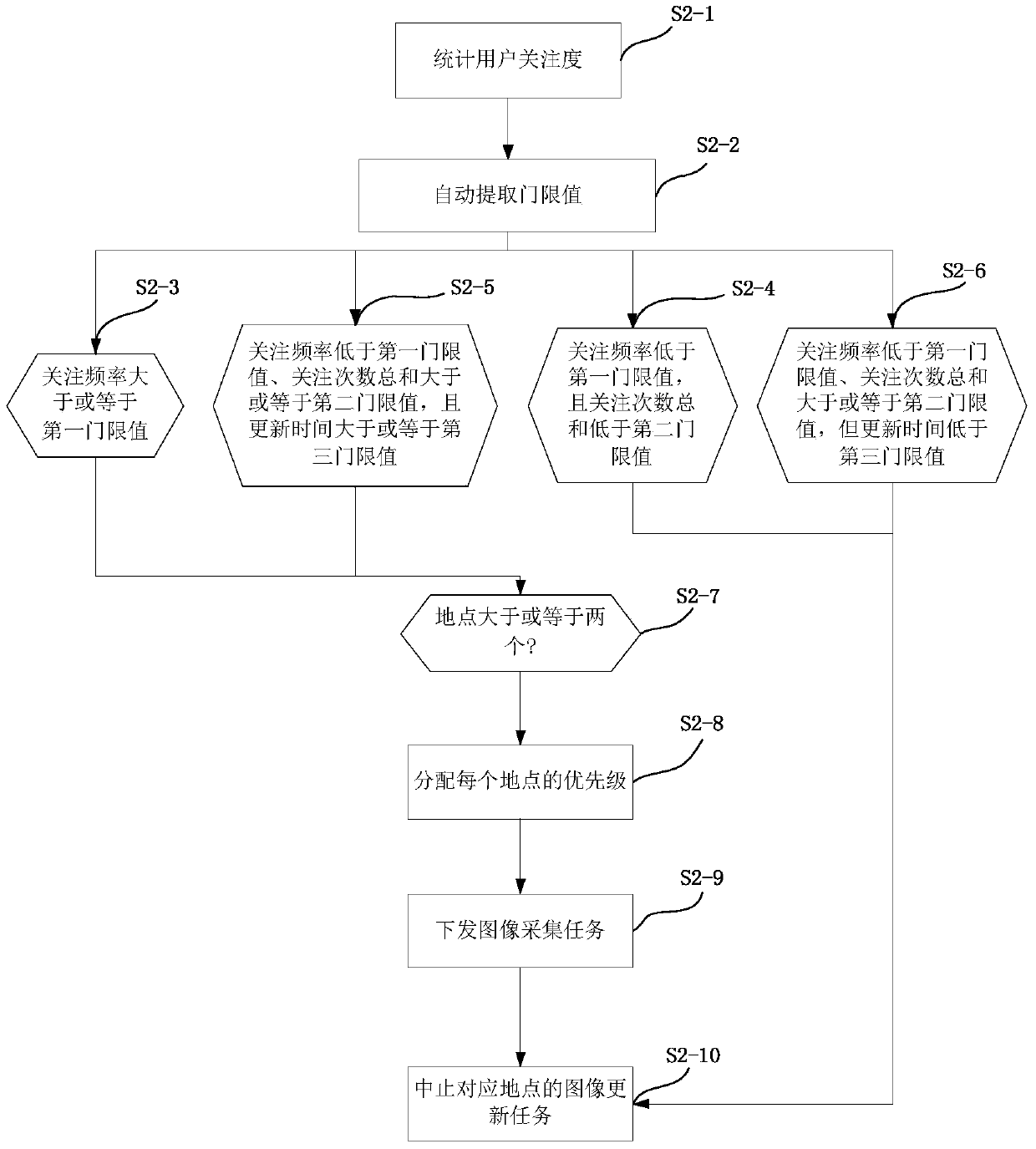
[0050] like figure 2 As shown, the method for updating the image information of the monitoring area in this embodiment.
[0051] S2-1. Statistically monitor the degree of attention of users with places in the monitoring area; the degree of user attention includes the frequency of attention, the sum of the number of times of attention and the update time, and the threshold value includes the first threshold value, the second threshold value and the third threshold value ; mobile camera devices including drones.
[0052] S2-2, automatically extracting the threshold value;
[0053] S2-3. If the frequency of interest is greater than or equal to the first threshold value; go to step S2-7;
[0054] S2-4. If the frequency of attention is lower than the first threshold, and the sum of the times of attention is lower than the second threshold, go to step S2-10;
[0055] S2-5. If the frequency of attention is lower than the first threshold, the sum of the times of attention is great...
Embodiment 3
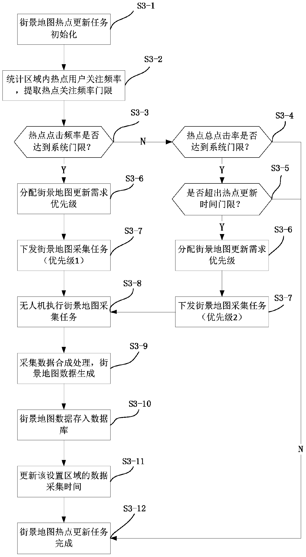
[0064] like image 3 As shown, this embodiment takes street view map update as an example to further illustrate the inventive concept of the present invention. The update method of the street view map includes the following steps:
[0065] S3-1. Street view map hotspot update task initialization;
[0066] S3-2. Counting the attention frequency of hotspot users in the area, and extracting the frequency threshold of hotspot attention;
[0067] S3-3. Does the hotspot click frequency reach the system threshold? If yes, go to step S6; if not, go to step S4;
[0068] S3-4. Has the total hit rate of hotspots reached the system threshold? If yes, go to step S5; if no, go to step S12;
[0069] S3-5. Is the hotspot update time threshold exceeded? If yes, go to step S6; if no, go to step S12;
[0070] S3-6. Allocating the priority of street view map update requirements;
[0071] S3-7. Issue a street view map collection task. If the conditions of step S3 and step S5 are both sati...
PUM
 Abstract
Description
Claims
Application Information