Method for quantitatively monitoring soil erosion change amount in real time for water and soil conservation comprehensive treatment

A technology for soil erosion and comprehensive control, applied in measurement devices, instruments, scientific instruments, etc., can solve the problems of time-consuming and labor-intensive, many observation indicators, and lack of real-time quantitative monitoring functions for treatment projects.

Active Publication Date: 2015-10-28
PEARL RIVER HYDRAULIC RES INST OF PEARL RIVER WATER RESOURCES COMMISSION
View PDF2 Cites 19 Cited by
  • Summary
  • Abstract
  • Description
  • Claims
  • Application Information

AI Technical Summary

Problems solved by technology

[0003] At present, in the comprehensive management of water and soil conservation, the change of soil erosion is still using "runoff small area observation test" and "small watershed comparison method". Although these methods can truly r

Method used


Image

  • Method for quantitatively monitoring soil erosion change amount in real time for water and soil conservation comprehensive treatment
  • Method for quantitatively monitoring soil erosion change amount in real time for water and soil conservation comprehensive treatment
  • Method for quantitatively monitoring soil erosion change amount in real time for water and soil conservation comprehensive treatment

Examples


Embodiment 1

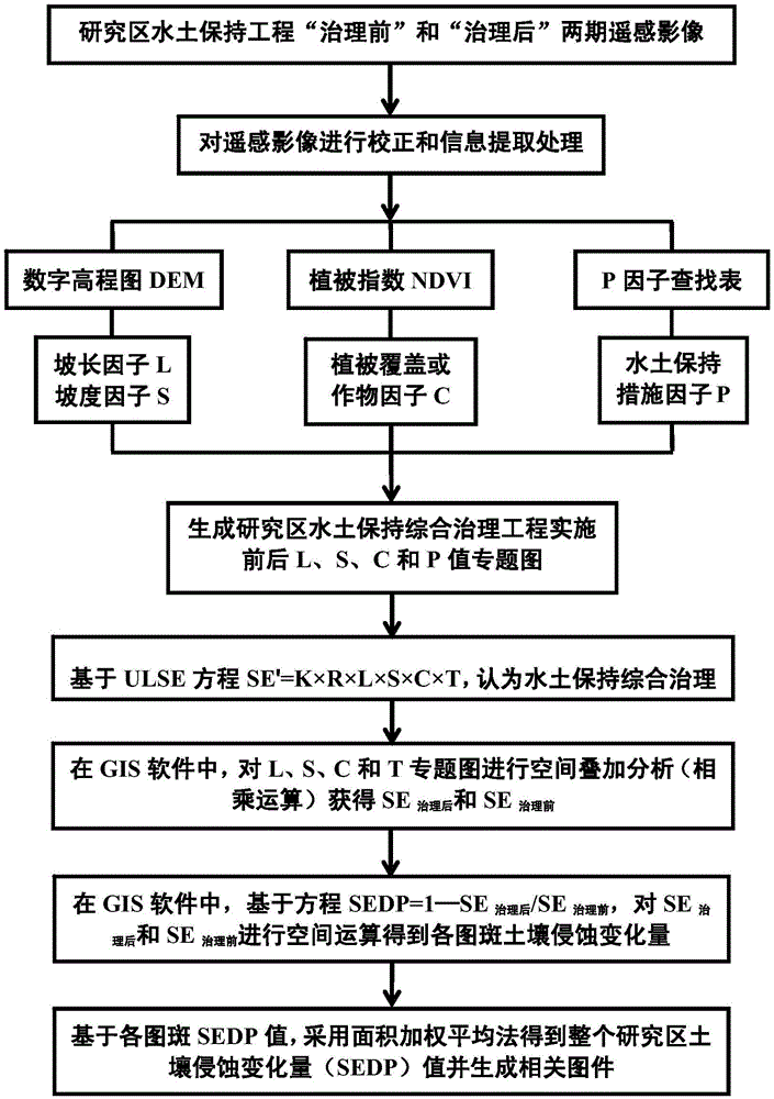
[0087] In this embodiment, a method for real-time quantitative monitoring of soil erosion variation in comprehensive management of water and soil conservation is based on the following working principle:

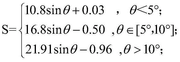
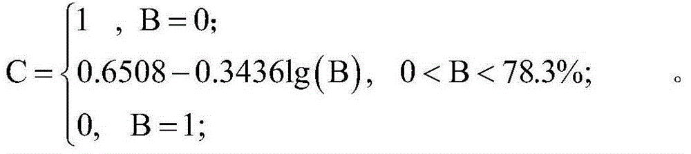
[0088] Based on the United States Universal Soil Erosion Equation (USLE) SE=K×R×L×S×C×P, where SE is the amount of soil erosion, t hm -2 a -1 ; K is soil erodibility factor, t hm 2 h -1 hm -2 mm -1 ; R is rainfall erosivity, MJ mm h -1 hm -2 a -1 ; L is the slope length factor; S is the slope factor; C is the vegetation or crop factor; P is the soil and water conservation measure factor. Then, the soil erosion reduction ratio SEDP is:

[0089] SEDP=1-SE' 治理前 / SE' 治理后

[0090] =1-(R 治理后 × K 治理后 × L 治理后 ×S 治理后 ×C 治理后 ×P 治理后 )÷(R 治理前 × K 治理前 × L 治理前 x

[0091] S 治理前 ×C 治理前 ×P 治理前 ) (1)

[0092] For a specific research area, there is no physical internal causal relationship between the rainfall erosivity (R) and soil erodibility (K) and the imple...


PUM


Abstract

The invention discloses a method for quantitatively monitoring the soil erosion change amount in real time for water and soil conservation comprehensive treatment. The method includes the steps that remote sensing images generated before and after water and soil conservation comprehensive treatment on a research area are acquired; a digital elevation model (DEM) and water and soil conservation measure remote sensing image pattern spots are extracted; the image pattern spots serve as a unit, and slope length factors L and gradient factors S of the pattern spots are calculated; vegetation coverage degrees B of the pattern spots are calculated through the normalized difference vegetation index (NDVI), and vegetation coverage or crop factors C of the pattern spots are estimated according to the vegetation coverage degrees B; water and soil conservation measure factors P of the pattern spots are assigned according to existing research results; the soil erosion amount reduction proportion SEDP is calculated according to the formula that SEDP=1-SE<after-treatment>/SE<before-treatment>, wherein the SE<before-treatment> and the SE<after-treatment> express the soil erosion amount obtained before water and soil conservation comprehensive treatment of the research area and the soil erosion amount obtained after water and soil conservation comprehensive treatment of the research area respectively. The soil erosion amount change can be acquired only through extraction of remote sensing image information, invested cost is relatively low, and the method is convenient and quick.

Description

technical field [0001] The invention relates to the research field of comprehensive control of water and soil conservation, in particular to a real-time quantitative monitoring method for soil erosion variation in comprehensive control of water and soil conservation. Background technique [0002] The change of soil erosion is the most direct reflection of the effectiveness of the comprehensive management of water and soil conservation, and it is also an important monitoring factor for the comprehensive management of water and soil conservation. [0003] At present, in the comprehensive management of water and soil conservation, the change of soil erosion is still using "runoff small area observation test" and "small watershed comparison method". Although these methods can truly reflect the change of soil erosion before and after treatment, there are many observation indicators and time-consuming It is labor-intensive and lacks the real-time quantitative monitoring function o...

Claims


Application Information

Patent Timeline
IPC IPC(8): G01N21/84
Inventor 黄俊亢庆金平伟李岚斌张自军刘斌韦聪谋方宗福徐舟
Owner PEARL RIVER HYDRAULIC RES INST OF PEARL RIVER WATER RESOURCES COMMISSION
Why Eureka
Try Eureka