A Height Reconstruction Method of Synthetic Aperture Radar Image

A synthetic aperture radar, image intensity technology, applied in image enhancement, image analysis, image data processing and other directions, can solve the problems of intuition of elevation image pilots, meaningless conversion work, large amount of calculation, etc., to achieve simple and powerful geometric relationship. Parallel processing capability to ensure real-time effect

Active Publication Date: 2017-12-15
BEIHANG UNIV
View PDF6 Cites 0 Cited by
  • Summary
  • Abstract
  • Description
  • Claims
  • Application Information

AI Technical Summary

Problems solved by technology

[0003] The key to height reconstruction is how to accurately calculate the actual altitude of the target, and the second is to project the target to an accurate position, otherwise, the resulting height difference or position offset will make the conversion work meaningless
[0004] The patented single-flight full-polarization synthetic aperture radar image retrieval method of ground digital elevation with the authorization number CN1234018C has a large amount of calculation, and the obtained elevation image is not as intuitive as perspective imaging for pilots.

Method used


Image

  • A Height Reconstruction Method of Synthetic Aperture Radar Image
  • A Height Reconstruction Method of Synthetic Aperture Radar Image
  • A Height Reconstruction Method of Synthetic Aperture Radar Image

Examples


Embodiment Construction

[0020] The present invention will be further described in detail with reference to the accompanying drawings and embodiments.

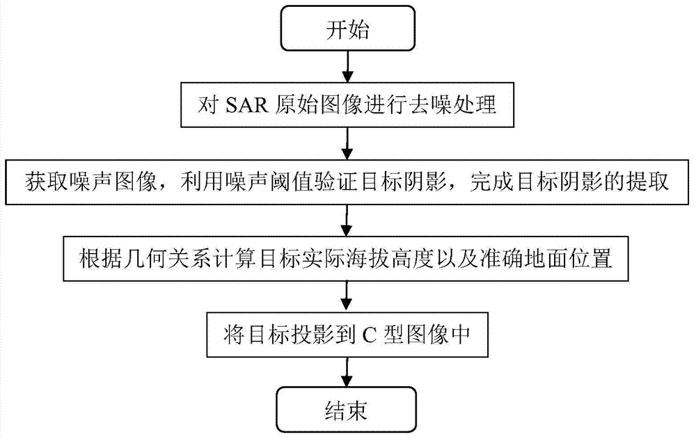
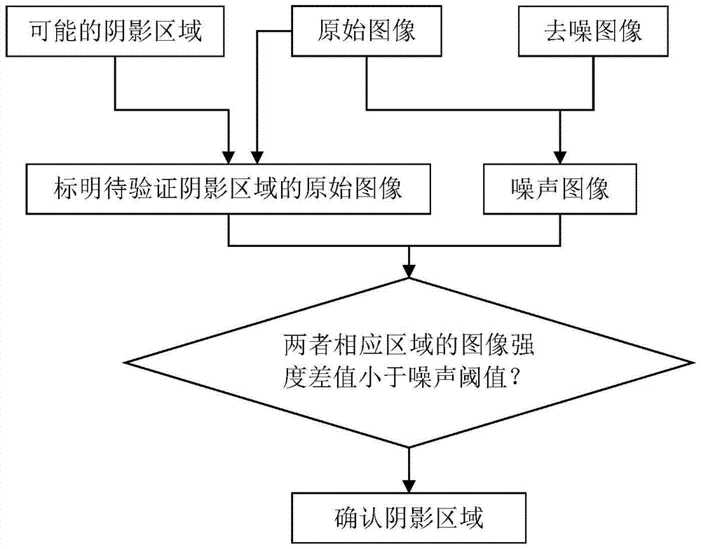
[0021] The synthetic aperture radar image height reconstruction method of the present invention obtains the possible shadow area through the denoising and edge detection processing of the SAR image, and then uses the shadow part of the image without echo, so the shadow part is in the original image and the noise The intensity of the image is theoretically equal, and the shadow of the target is extracted. Finally, the actual altitude of the target is calculated according to the geometric relationship and projected into the C-type image.

[0022] The present invention is a height reconstruction method of a synthetic aperture radar image, such as figure 1 shown, including the following steps:

[0023] Step 1: Denoise the synthetic aperture radar original image (SAR original image).

[0024] The original image is processed by the wavelet denoising metho...


PUM


Abstract

The invention discloses a height reconstruction method of a synthetic aperture radar image. The method comprises the steps of: 1, carrying out de-noising processing on the synthetic aperture radar image and obtaining a de-noised image; 2, obtaining a noise image, utilizing a noise threshold to verify an object shadow, and finishing the extraction of the object shadow; 3, calculating the practical altitude height and accurate ground position of an object according to geometrical relations; 4, mapping the object to a C type image. According to the invention, only a single SAR image is needed, so that the higher practicality is realized; in the invention, how to utilize a B type image, a radar equipment height, wave beams and a ground level included angle to determine the practical position of the object is discussed, and the corresponding C type image can be obtained according to the position of the object; in addition, the method can be used for obstacle detection and height judgment in launching and landing processes of the airborne synthetic aperture radar, thereby ensuring the real-time performance and providing important significance to flight safety.

Description

technical field [0001] The invention relates to the technical field of radar image processing, in particular to a method for reconstructing the height of a Synthetic Aperture Radar (SAR) image. Background technique [0002] Synthetic aperture radar is more and more widely used, and its image is usually displayed as a B-scope display, which displays the distance on the vertical axis and the azimuth of the radar on the horizontal axis, that is, the distance-angle display. In the B-type display, different targets with the same azimuth angle may be presented at the same point, and it is difficult to distinguish the difference in height. The C-type display (C-scope) provides a new option for the target. The C-type display image is processed and converted according to the B-type display image, and the altitude is provided in the form of elevation angle. This angle-angle display is consistent with the effect of ordinary optical imaging, similar to the scene directly observed by th...

Claims


Application Information

Patent Timeline
Patent Type & Authority Patents(China)
IPC IPC(8): G06T5/00G06T7/70G01S7/04G01S13/90
Inventor 赵永嘉胡雪蕊雷小永戴树岭
Owner BEIHANG UNIV
Why Eureka
Try Eureka