A Vehicle Tracking Method Based on GPS and Electronic Compass

An electronic compass and vehicle tracking technology, which is applied to radio wave measurement systems, satellite radio beacon positioning systems, measurement devices, etc., can solve the problems that cannot be used to determine relative positions, and achieve the effect of precise vehicle trajectory

Active Publication Date: 2017-05-10
嘉善县惠丽包装材料厂
View PDF4 Cites 0 Cited by
  • Summary
  • Abstract
  • Description
  • Claims
  • Application Information

AI Technical Summary

Problems solved by technology

It can be seen that using GPS to locate the vehicle, the error will not be less than the meter level. Such an accurate GPS can only be used to determine the general position of the vehicle, but not the relative position of the vehicle to a certain traffic sign line.

Method used


Image

  • A Vehicle Tracking Method Based on GPS and Electronic Compass
  • A Vehicle Tracking Method Based on GPS and Electronic Compass
  • A Vehicle Tracking Method Based on GPS and Electronic Compass

Examples


Embodiment Construction

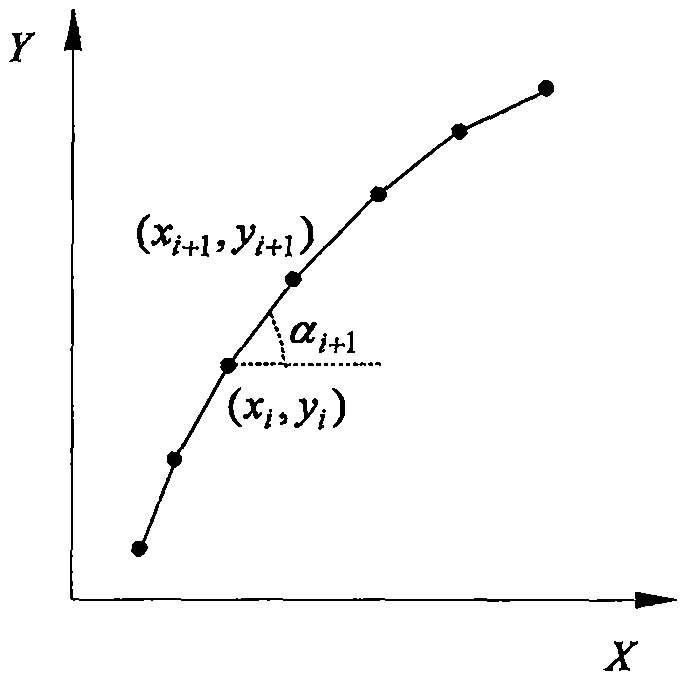
[0010] 1. Establish a ground Cartesian coordinate system

[0011] The ground Cartesian coordinate system is established with the starting point of the vehicle on the road as the origin, such as figure 1 shown. The horizontal axis is the tangent of the latitude passing through the origin, and the direction is right; the vertical axis is the tangent of the meridian passing through the origin, and the direction is upward.

[0012] 2. Obtain positioning data

[0013] Since the track of the vehicle under investigation is near the origin of the Cartesian coordinate system defined above, it can be considered that the vehicle is running in the coordinate plane. According to the idea of ​​calculus, any curve can be regarded as being connected by straight line segments with enough points. Assuming that the GPS pseudo-range differential positioning data of the vehicle and the angle data of the vehicle-mounted digital electronic compass are sampled at the same time at a period T, and t...


PUM


Abstract

The invention provides a vehicle tracking method based on GPS pseudo range differential positioning data and a vehicle-mounted electronic compass. According to the method, the GPS pseudo range differential positioning data of a vehicle and the angle data of the vehicle-mounted electronic compass are simultaneously acquired periodically, and two types of data are fused by a data fusion method so that vehicle moving tracks after error correction can be given in real time. The beneficial effects of the vehicle tracking method are that error accumulation of the angle of the vehicle-mounted electronic compass is not generated, and the GPS pseudo range differential positioning data can be effectively corrected so that more accurate vehicle moving tracks can be provided.

Description

technical field [0001] The invention relates to a vehicle tracking method based on GPS and electronic compass. Background technique [0002] With the progress of our country's society and the development of economy, the number of motor vehicles continues to increase. Although the road traffic conditions have also been greatly improved, the speed of improvement lags far behind the increase of vehicles. The contradiction of more vehicles and fewer roads is becoming more and more obvious, resulting in traffic congestion, increasing traffic accidents and other social problems that need to be solved urgently. . However, in order to solve the problems faced by road traffic, according to the traditional traffic development strategy, it is not feasible to only increase the area of ​​roads, increase the overall capacity of the road network, and improve the layout of the road network. Because this kind of development model not only has a relatively high cost, but also has a relative...

Claims


Application Information

Patent Timeline
Patent Type & Authority Patents(China)
IPC IPC(8): G01S19/48
CPCG01S19/48
Inventor 安凯安培亮安宏亮王晓英
Owner 嘉善县惠丽包装材料厂
Why Eureka
Try Eureka