Urban main built-up area remote sensing extraction method based on impervious surface aggregation density

A technology of aggregation density and extraction method, which is applied in the field of remote sensing extraction of main urban built-up areas based on the aggregation density of impermeable surfaces, can solve the problems that the integrity of the underlying surface type cannot be guaranteed, and achieve good input and support, and ensure integrity Effect

Inactive Publication Date: 2015-11-25
INST OF REMOTE SENSING & DIGITAL EARTH CHINESE ACADEMY OF SCI
View PDF2 Cites 16 Cited by
  • Summary
  • Abstract
  • Description
  • Claims
  • Application Information

AI Technical Summary

Problems solved by technology

George Xian determined the urban-rural boundary and urban development density by selecting a specific

Method used


Image

  • Urban main built-up area remote sensing extraction method based on impervious surface aggregation density
  • Urban main built-up area remote sensing extraction method based on impervious surface aggregation density
  • Urban main built-up area remote sensing extraction method based on impervious surface aggregation density

Examples


Embodiment Construction

[0026] The "A method for extracting main urban built-up areas based on the density of impermeable surfaces" of the present invention will be further elaborated below in conjunction with the accompanying drawings.

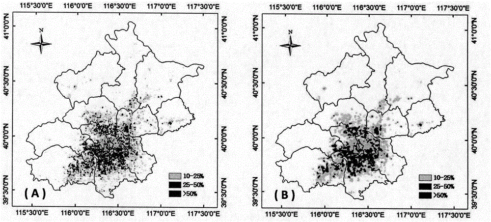
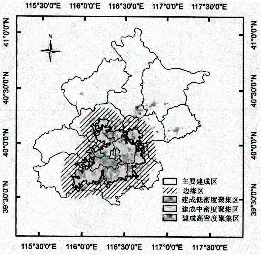
[0027] The "calculation method for the accumulation density of impermeable surfaces" involved in the present invention is an important technical innovation for measuring the degree of aggregation of urban impermeable surfaces. Among them, based on the calculation of the accumulation density of impervious surfaces, the effective scope of the main urban built-up area can be obtained, which provides accurate input of urban and suburban boundaries for the calculation of heat island intensity.

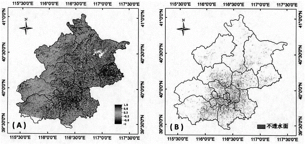
[0028] (1) Extraction of impervious surface information based on BCI index

[0029] Before calculating the BCI index, it is necessary to carry out three steps of preprocessing on the remote sensing image: the first is radiometric calibration; the second is water body mask; the th...


PUM


Abstract

The invention discloses an urban main built-up area remote sensing extraction method based on impervious surface aggregation density in view of a problem of direct influence of suburban boundary extraction on accuracy of heat island intensity calculation in urban heat island effect extraction. The method comprises the following steps that step 1) urban impervious surface information is extracted by utilizing a threshold value method based on a biophysical composition index BCI for distinguishing urban targets, and precision verification is performed; step 2) the extracted impervious surface image element points act as centers and distance acts as weight, weight of the impervious surface image elements closer to the center points is higher, and aggregation degree of buildings within a radius range is measured; and step 3) a distance threshold value and an aggregation threshold value are set through combination of the extracted impervious surface aggregation density based on geographical location of impervious surface distribution according to an urban clustering algorithm so that the impervious surface aggregation area distribution condition is obtained, and range of urban built-up areas is confirmed.

Description

technical field [0001] The invention relates to a remote sensing extraction method for main urban built-up areas based on the accumulation density of impermeable surfaces. The invention can better measure the aggregation degree and distribution density of urban impermeable surfaces, effectively distinguish the boundaries of urban and suburban areas, and extract the scope of main urban built-up areas to ensure The integrity of the underlying surface type can provide good input and support for urban heat island effect calculation and urban planning. Background technique [0002] Previous remote sensing studies on the urban heat island effect generally used methods such as urban administrative boundaries, urban impervious surfaces, and land classification to distinguish built-up areas from suburban areas. The administrative boundary of the city only represents the legal boundary of the city, and the administrative boundary cannot replace the real core built-up area of ​​the cit...

Claims


Application Information

Patent Timeline
IPC IPC(8): G06K9/00
CPCG06V20/176
Inventor 孟庆岩张琳琳王靓张佳晖孙云晓
Owner INST OF REMOTE SENSING & DIGITAL EARTH CHINESE ACADEMY OF SCI
Why Eureka
Try Eureka