A wide-lane ambiguity resolution method based on fusion of bds and gps observation information

A wide-lane ambiguity and ambiguity technology, applied in the field of global navigation satellite system satellite positioning, can solve the problems of high success rate, difficult three-frequency observation information fusion, and insufficient use of redundant information, so as to ensure timeliness and improve The effect of efficiency and reliability

Active Publication Date: 2017-07-28
SOUTHEAST UNIV
View PDF4 Cites 0 Cited by
  • Summary
  • Abstract
  • Description
  • Claims
  • Application Information

AI Technical Summary

Problems solved by technology

However, for the dual-frequency case, the resolution of the wide-lane ambiguity is still an urgent problem to be solved: Although the MW combination method eliminates the influence of ionospheric and tropospheric delays, it is based on a single satellite pair and does not make full use of each satellite. The redundant information provided by satellite pairs requires a long time to achieve a high success rate, and it is based on a geometrically independent model, which makes it difficult to effectively fuse with the tri-frequency observation information; and the conventional WL method cannot be effective Solve the problem of ionospheric delay, the main factor affecting the fixation of medium and long baseline ambiguity

Method used


Image

  • A wide-lane ambiguity resolution method based on fusion of bds and gps observation information
  • A wide-lane ambiguity resolution method based on fusion of bds and gps observation information
  • A wide-lane ambiguity resolution method based on fusion of bds and gps observation information

Examples


Embodiment

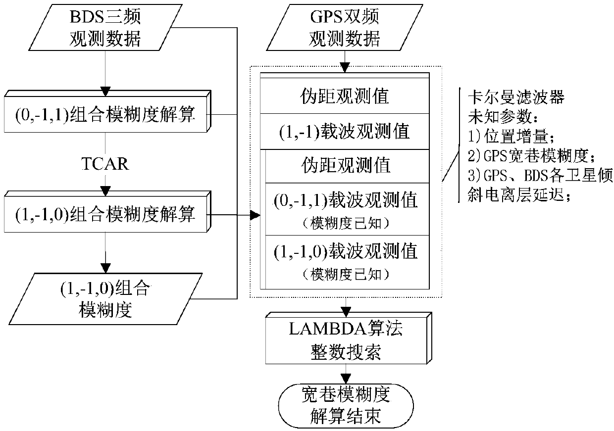
[0045] Example: A set of baseline data with a length of 74 km in the Henan CORS network was selected for experimental verification, and the data was collected at 4:00-5:00 UTC on March 7, 2014.

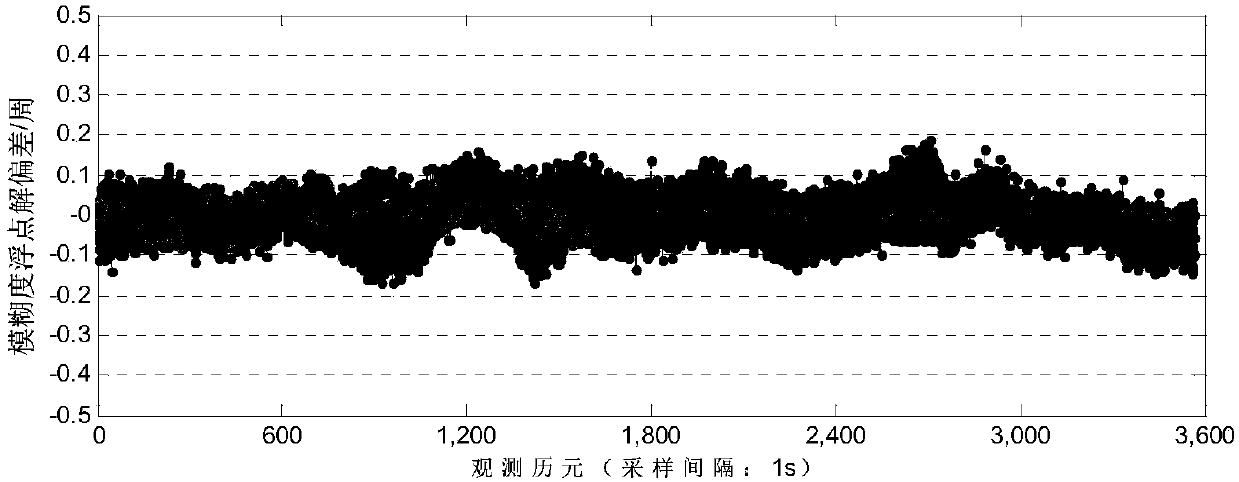
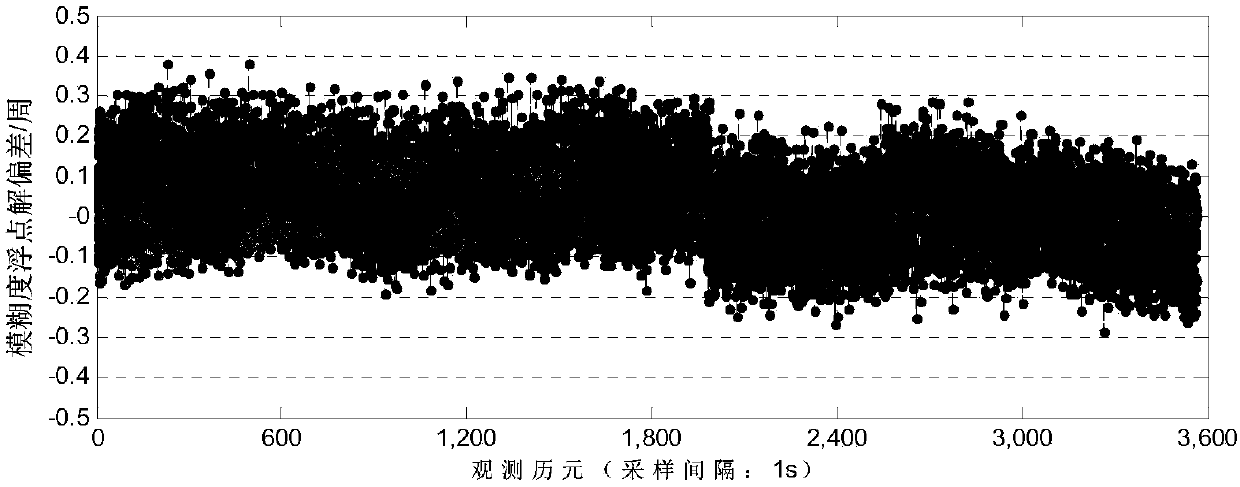
[0046] figure 2 and image 3 The single epoch solution deviations of the combined ambiguities of the satellites (0,-1,1) and (1,-1,0) of the tri-frequency BDS are respectively given, and the reference value is determined by the smooth solution of the whole solution interval data. have to. It can be seen that the deviation of the (0,-1,1) combination ambiguity calculated by a single epoch is basically within ±0.1 weeks, and the rounding of a single epoch can reliably fix the ambiguity of the whole week; from image 3 It can be seen that the deviation of the combined ambiguity of (1,-1,0) is larger than that of (0,-1,1), this is because the TCAR model is still affected by the residual ionospheric error, and the ambiguity noise is compared with (0,-1,1) also becomes larger, but its c...


PUM


Abstract

The invention discloses a wide lane ambiguity resolution method through BDS and GPS observation information fusion. The method comprises the steps of firstly, using the triple-frequency advantage of a BDS and performing preferred and reliable single-epoch fixing of the combination ambiguity of a ultra wide lane and a wide lane of the BDS; and secondly, using short-term stable variation characteristics of ionized layer delay, parameterizing inclining ionized layer delay values of different satellites of the BDS and the GPS, and using the ionized layer frequency relationship for simultaneously solving different combination observation values (including a pseudo-range), wherein, the BDS comprises pseudo-range observation values at three frequency points and ultra wide lane or wide lane observation values with two fixed ambiguities and the GPS comprises pseudo-range observation values at two frequency points and wide lane observation values with the wide lane ambiguity to be evaluated. Common position increment parameters are used for fusion of the above observation information, and a geometric correlation model is made for kalman filtering. The method provided by the invention can be used for significantly increasing the resolution precision and speed of the wide lane ambiguity of a dual-frequency system, especially of a low altitude angle satellite.

Description

technical field [0001] The invention relates to a global navigation satellite system (GNSS) satellite positioning method, in particular to fast and accurate resolution of ambiguity in carrier-based multi-frequency multi-system RTK (Real-Time Kinematic). Background technique [0002] Carrier-based RTK (Real-Time Kinematic) technology is one of the most widely used GNSS precision positioning technologies at present. It allows users to obtain centimeter-level positioning results conveniently and in real time. It has been used in precision engineering surveys, land and resources surveys, etc. field until it is widely used. In recent years, with the operation of my country's Beidou system (BDS), the construction of Galileo and IRNSS, and the improvement of GPS and GLONASS, satellite navigation has entered a new era of multi-system coexistence. Multi-mode and multi-frequency observation information is the key to satellite positioning accuracy and reliability Such performance impro...

Claims


Application Information

Patent Timeline
Patent Type & Authority Patents(China)
IPC IPC(8): G01S19/44
CPCG01S19/44
Inventor 潘树国高旺高成发
Owner SOUTHEAST UNIV
Why Eureka
Try Eureka