
Electromagnetic-simulation-based evaluation method for unmanned plane planning route

An electromagnetic simulation and unmanned aerial vehicle technology, which is applied in the field of visual simulation and electromagnetic simulation, can solve the problems of long flight time, high cost, and the evaluation effect has no universal significance, and achieve the effect of expanding the scope of use

Active Publication Date: 2015-12-23
BEIHANG UNIV
View PDF5 Cites 28 Cited by
  • Summary
  • Abstract
  • Description
  • Claims
  • Application Information

AI Technical Summary

Problems solved by technology

However, due to the long flight time and high cost of this method, and the flight area is limited by the actual environment, its evaluation effect has no universal significance

Method used


Image

  • Electromagnetic-simulation-based evaluation method for unmanned plane planning route
  • Electromagnetic-simulation-based evaluation method for unmanned plane planning route
  • Electromagnetic-simulation-based evaluation method for unmanned plane planning route

Examples


Embodiment Construction

[0053] The present invention will be described in detail below in conjunction with the accompanying drawings.

[0054] For the specific performance architecture of the virtual test flight field system, see Figure 4 .

[0055] Such as Figure 4 As shown, the system architecture is divided into data layer, data transmission layer, application layer, presentation layer and result layer. The data layer includes geographical environment library, meteorological environment library, planning route library, UAV model library and electromagnetic propagation model library; the data transmission layer is mainly to call the model libraries of the data layer to simulate and calculate the electromagnetic environment; the application layer is the system The main functional modules include flight test field display platform control, environmental information processing, UAV flight track control and data link electromagnetic simulation modeling; the presentation layer is the display module ...


PUM


Abstract

The invention discloses an electromagnetic-simulation-based evaluation method for an unmanned plane planning route. The method comprises the following steps: step one, carrying out virtual test flight field system construction and field configuration; step two, driving an unmanned plane to carry out simulated flight along a planned route; step three, carrying out simulated calculation of electromagnetic data; step four, carrying out electromagnetic distribution display and route warning recording; and step five, carrying out integrated route evaluation. According to the invention, electromagnetic distribution of the unmanned plane can be displayed visually on the planned route; and a route (segment) lower than a data link electromagnetic signal detection threshold value can be warned and recorded and thus the route (segment) can be evaluated after flight completion.

Description

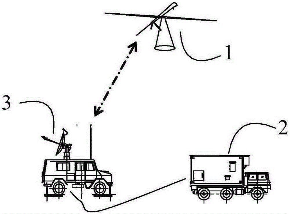
technical field [0001] The invention relates to simulation training technology for unmanned aerial vehicles, in particular to the fields of visual simulation, electromagnetic simulation, etc., and specifically refers to an evaluation method for planning flight routes of unmanned aerial vehicles. Background technique [0002] UAVs have the advantages of accurate, efficient and convenient reconnaissance, interference and combat under unconventional conditions, and play a significant role in civilian and military applications. figure 1 It is a schematic diagram of the position of the ground control station in the UAV measurement and control system. figure 1 It is a simplified model of the measurement and control and information transmission system. The ground command station 2 completes the state monitoring and operation control of the UAV 1 through the vehicle measurement and control station 3. The vehicle measurement and control station 3 and the UAV 1 form a measurement and ...

Claims


Application Information

Patent Timeline
Patent Type & Authority Applications(China)
IPC IPC(8): G05D1/10G05D1/08
Inventor 丁文锐张薇玮向锦武陈彦冠
Owner BEIHANG UNIV
Learn More