Northeast region paddy field classification and information extraction system and method

An information extraction and paddy field technology, applied in the field of land and resources information processing, can solve the problem of no paddy field refinement classification, etc., achieve the effect of efficient extraction and avoid resource waste

Active Publication Date: 2015-12-23
NORTHEAST AGRICULTURAL UNIVERSITY
View PDF3 Cites 11 Cited by
  • Summary
  • Abstract
  • Description
  • Claims
  • Application Information

AI Technical Summary

Problems solved by technology

However, the current land management departments and academic circles have not classified paddy fields in detail for this phenomenon.

Method used


Image

  • Northeast region paddy field classification and information extraction system and method
  • Northeast region paddy field classification and information extraction system and method
  • Northeast region paddy field classification and information extraction system and method

Examples


Embodiment Construction

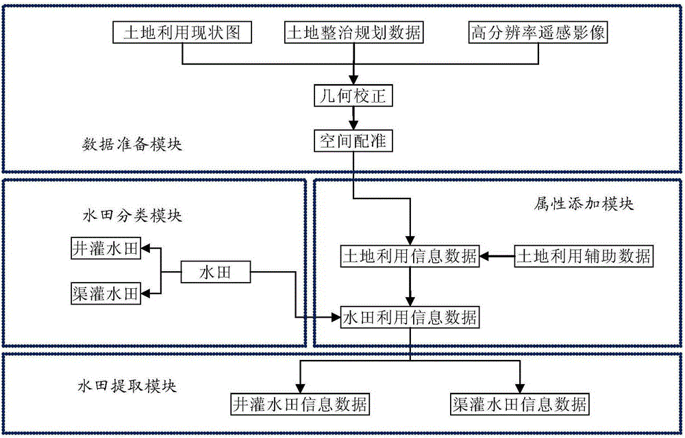
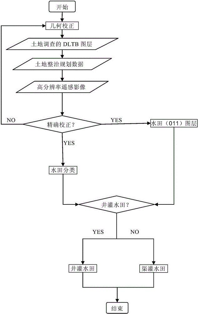
[0020] Such as figure 1 As shown, a paddy field classification and information extraction system in Northeast China of the present invention includes four parts: a data preparation module, a paddy field classification module, an attribute addition module and a paddy field extraction module.

[0021] (1) Based on the collection of the current land use map of the study area at the same time period, that is, the DLTB layer of land types and patches based on the second land survey held by the Ministry of Land and Resources, high-resolution remote sensing images with a resolution of 1-8m, and land consolidation planning data Because different data sources have different spatial reference systems, multi-source data superposition has deviations, so with the help of ArcGIS, ENVI and other software, use the DLTB layer of land survey as the benchmark data to analyze high-resolution remote sensing images, land consolidation planning, etc. The data is geometrically corrected, and the data...


PUM


Abstract

A northeast region paddy field classification and information extraction system and a method are disclosed. The system comprises four portions of data preparation, paddy field classification, attribute addition and paddy field extraction. According to northeast-region cultivated land utilization realities, the paddy fields are divided into a ''well irrigation paddy field'' and a ''canal irrigation paddy field''. The well irrigation paddy field is the paddy field which is irrigated by underground water pumped through using a motor-pumped well. The 'canal irrigation paddy field is the paddy field which is irrigated by water sources of a canal system irrigation channel, a lake, a river, a reservoir, a pond and the like. Through a land, by using a current state data, a high-resolution remote sensing image, land reclamation data and other data, according to a canal system distribution state, classification and extraction of the 'well irrigation paddy field and the canal irrigation paddy field are realized through visual interpretation. Generally speaking, the paddy field in an irrigated area is the canal irrigation paddy field and the canal irrigation paddy field has relatively complete channel systems of a main canal, a branch canal, a lateral canal, a sublateral canal and the like; a canal system of a well irrigation paddy field area is simple and does not form a system; a surrounding electro-mechanical well is radiated outwardly; the channel is narrow; and a northeast region well irrigation paddy field area generally has a sunning water pool with a large area.

Description

technical field [0001] The invention relates to a classification and extraction technology of cultivated land utilization types, in particular to a paddy field classification and information extraction system and method in Northeast China, belonging to the technical field of land resources information processing. Background technique [0002] At present, the current land use classification system (GB / T21010-2007) divides cultivated land into three categories: paddy field, dry land, and irrigated land. Among them, paddy field mainly refers to the cultivated land used to grow aquatic crops such as rice and lotus root. Northeast China belongs to the continental humid and semi-humid monsoon climate zone, which is suitable for rice cultivation, but its annual rainfall fluctuates greatly. Agricultural production is generally irrigated by water conservancy facilities, and the water source is groundwater or surface water. Due to the difference in temperature between the two , has a ...

Claims


Application Information

Patent Timeline
Patent Type & Authority Applications(China)
IPC IPC(8): G06K9/00G06K9/46
CPCG06V20/13G06V10/44
Inventor 杜国明孙晓兵张露洋冯悦
Owner NORTHEAST AGRICULTURAL UNIVERSITY
Why Eureka
Try Eureka