
Electric power typhoon disaster resistance simulation analysis early warning system based on three-dimensional digital Earth

A three-dimensional digital and simulation analysis technology, applied in data processing applications, instruments, climate sustainability, etc., can solve problems such as the lack of an effective analysis method for the impact of typhoons on the power grid, the lack of realism, and the inability to effectively assess the impact of typhoons in a timely manner. To achieve the effect of improving computing efficiency and improving accuracy

Active Publication Date: 2015-12-23
STATE GRID FUJIAN ELECTRIC POWER CO LTD +2
View PDF5 Cites 29 Cited by
  • Summary
  • Abstract
  • Description
  • Claims
  • Application Information

AI Technical Summary

Problems solved by technology

[0009] (1) The two-dimensional geographic information system can only display the power grid form in two-dimensional form, and cannot intuitively understand the line corridors, crossovers, surrounding geographical environment, topography, etc.
[0010] (2) The existing scheme mainly uses meteorological professional symbols to display typhoon meteorological data, which lacks a sense of reality, is not easy for non-meteorological professionals to understand, and is difficult to provide effective support for power grid disaster commanders
[0011] (3) Although meteorological information can be associated with the power grid system, an effective analysis method for the impact of typhoons on the power grid has not been established, and the impact of typhoons on the power grid cannot be evaluated in a timely and effective manner, so that the associated meteorological information has no real effect on the early warning of the power grid

Method used


Image

  • Electric power typhoon disaster resistance simulation analysis early warning system based on three-dimensional digital Earth
  • Electric power typhoon disaster resistance simulation analysis early warning system based on three-dimensional digital Earth
  • Electric power typhoon disaster resistance simulation analysis early warning system based on three-dimensional digital Earth

Examples


Embodiment Construction

[0025] The present invention will be further described below in conjunction with the accompanying drawings and specific embodiments.

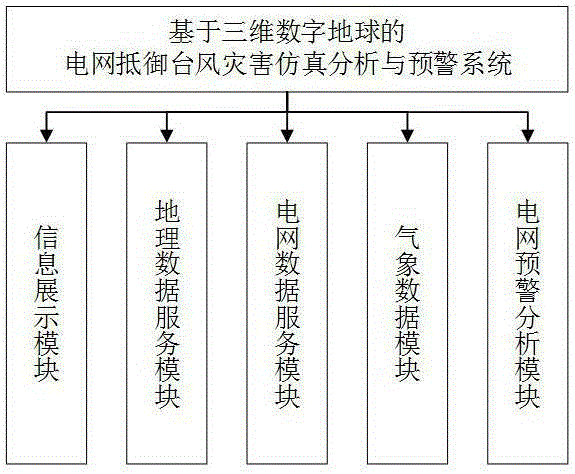
[0026] The present invention provides a simulation analysis and early warning system for power grid resisting typhoon disasters based on a three-dimensional digital earth. The system includes an information display module, a geographic data service module, a power grid data service module, a meteorological data module, and a power grid early warning analysis module. For a structural principle block diagram, see figure 1 .

[0027]Wherein: the information display module provides 3D digital earth, 3D power grid, 3D meteorological environment, meteorological thematic map and power grid early warning functions, and provides a 3D virtual reality browsing environment for the system; the geographic data service module is the information display module and power grid The early warning analysis module provides geographic data services; the grid data ser...


PUM


Abstract

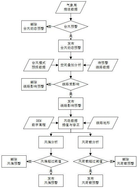
The invention provides an electric power typhoon disaster resistance simulation analysis early warning system based on the three-dimensional digital Earth. The system comprises an information display module, a geographical data service module, an electric power data service module, a meteorological data module and an electric power early warning analysis module. According to the system, the three-dimensional digital Earth is taken as a display carrier, electric power equipment, the meteorological environment and the geographical environment are combined together, so a multi-layer spatial structure of the electric power network is intelligibly displayed, and relationship and influence between the electric power and the geographical environment and between the electric power and the meteorological environment are further displayed; the meteorological environment is established in the three-dimensional environment, simulation leads capable of simulating wind swinging and broken line dropping are constructed in the three-dimensional electric power, typhoon broadcasting data is utilized for electric power early warning and analysis, and correction is carried out according to geographical situations, accuracy is not only improve, but also calculation efficiency is further improved, influence of typhoon exerted on the electric power can be predicted, and powerful support can be provided for electric power typhoon disaster resistance.

Description

technical field [0001] The invention relates to the field of disaster prevention and mitigation of power grids, and mainly relates to the analysis and early warning of power facilities against typhoon disasters, the visualization of power grids and atmospheric environments, and the visualization of analysis and early warning based on the three-dimensional digital earth environment. Background technique [0002] Digital Earth: a virtual earth system based on earth coordinates, with multi-resolution massive data and multi-dimensional display. [0003] 3D visualization: Using computer graphics and image processing technology to convert data into 3D graphics or images and display them on the screen. [0004] Geographical Information System: GIS, a technical system that collects, stores, manages, calculates, analyzes, displays and describes geographically distributed data in the entire or part of the earth's surface (including the atmosphere) space with the support of computer ha...

Claims


Application Information

Patent Timeline
IPC IPC(8): G06Q10/06G06Q50/06
CPCY02A90/10
Inventor 林嘉林承华梁曼舒汤振立罗富财
Owner STATE GRID FUJIAN ELECTRIC POWER CO LTD
Learn More